| Kingston to Lyndhurst/Delta Loop |
base map courtesy Parks Canada
|
| |
Location |
Description |
 |
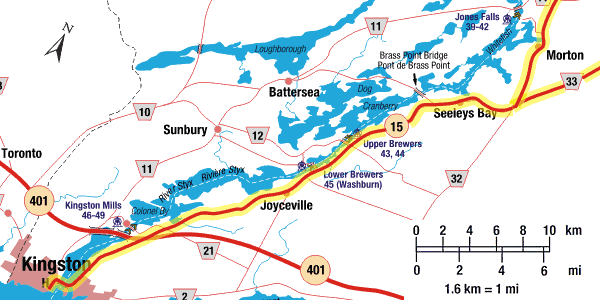
Kingston |
Starting at the historic Murney Tower Museum (located on the waterfront, beside King Street West, near the intersection with Barrie Street), head east to West Street, turn south to Ontario Street and take Ontario Street across the bridge to Highway 2. Stop at Fort Henry. From Fort Henry continue on Hwy 2 east to the lights at the top of the hill and turn north (left) onto Highway 15. Follow Highway 15 north. |
 |
Kingston Mills |
Just north of the bridge over the railway tracks, you'll see signs for the Kingston Mills lockstation. Take Kingston Mills Road 2 kilometres east to the Kingston Mills Lockstation. Beautiful scenery, picnic tables and washrooms. |
|
Highway 15 |
Continue north on Highway 15. You will pass turn off to Lower Brewers Lockstation, Upper Brewers Lockstation and the village of Seeleys Bay. |
 |
Hwy 15 or Cty Rd 33 |
Just a couple of km north of the turn-off for the Village of Seeleys Bay is a route choice. You can continue up Highway 15 or take County Road 33 through Lyndhurst and Delta. A suggested visit on the Highway 15 portion is Jones Falls Lockstation, one of the prettiest locks on the Rideau Canal (see the side-loop description). You can continue along Hwy 15 to Morton and then to Jones Falls, or take the Cty Rd 33 and loop to Crosby and come back to Jones Falls. |
| Lyndhurst/Delta Loop |
base map courtesy Parks Canada
|
 |
Cty. Rd. 33 |
Turn onto County Road 33 and follow it to the Village of Lyndhurst. |
 |
Lyndhurst |
An interesting stop in the Village of Lyndhurst is the old stone bridge, built in 1856-57, the oldest stone bridge still in use in Ontario. |
|
Cty Rd 33 |
From Lyndhurst, continue north on County Road 33 to its intersection with County Road 42 |
 |
County Road 42 |
Turn left (west) onto County Road 42 and follow it to the Village of Delta |
|
Delta |
One of the standout features in the Village of Delta is the Old Stone Mill, built in 1810, now open to the public with many interesting displays. |
|
County Road 42 |
From Delta, continue north on County Road 42 though Philipsville, Forfar (stop at the Forfar Cheese Factory) and on to Crosby, located at the intersection with Highway 15. This ends this loop.
At this point you could continue on the route, north on Highway 15, take the Newboro/Westport/Perth/Rideau Ferry loop, or take a side-trip south to visit either (or both) Jones Falls Lockstation and/or Chaffeys Lockstation (see the Highway 15 route description for full details) |
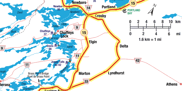
| Highway 15 - Morton to Crosby |
|
Highway 15 |
Continue north on Highway 15 through the Village of Morton. Just north of Morton you might wish to take a side trip to the Jones Falls Lockstation (see below). Continuing north you'll pass the Village of Elgin, a service hub for the area. North of Elgin you might wish to do a side trip to visit Chaffeys Lockstation (see below). Continuing north you'll come to Crosby.
|
|
Jones Falls |
The Jones Falls Road exit is located on Highway 15, just north of Morton. A few kilometres will bring you to Jones Falls, arguably the most beautiful lockstation on the Rideau Canal. It's a lovely spot to do some boat watching or have a picnic. |
|
Chaffeys |
The Chaffeys Lock Road exit is located on Highway 15, just north of Elgin. A few kilometres will bring you to Chaffeys Lock, which, in addition to the lock itself, features the Lockmaster's House Museum. |
|
Hwy 15 or Cty Rd 42 |
At Crosby, you'll have another choice of route - either continue along Highway 15 to the north, or turn left (west) and take the Newboro/Westport/Perth/Rideau Ferry loop. |
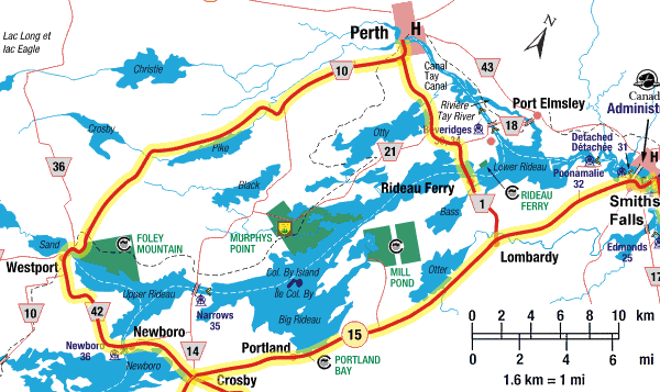
| Newboro/Westport/Perth/Rideau Ferry Loop |
base map courtesy Parks Canada
|
|
Cty Rd 42 |
From Crosby, take County Road 42 west to Newboro |
|
Newboro |
The Village of Newboro features some interesting shopping opportunities as well as the Newboro lockstation, which includes one of only four blockhouses along the Rideau Canal. |
|
Cty Rd 42 |
From Newboro, take County Road 42 west to Westport |
|
Westport |
The Village of Westport is nestled at the west end of Upper Rideau Lake. It offers many accommodation, dining and shopping opportunities as well as a lovely view of the area from Spy Rock in the Foley Mountain Conservation area. |
|
Cty Rd 10 |
From Westport, take County Road 10 north to Perth |
|
Perth |
The Town of Perth features beautiful historic stone architecture as well as many accommodation, dining and shopping opportunities. |
|
Cty Rd 1 |
From Perth, take County Road 1 east to Rideau Ferry. Continue east from Rideau Ferry on County Road 1 to Lombardy. At Lombardy this route will intersect with the Highway 15 route. |
| Highway 15 - Crosby to Smiths Falls |
|
Highway 15 |
From Crosby, continue north on Highway 15 to Portland
|
|
Portland |
The Village of Portland is on Big Rideau Lake, the largest and deepest lake on the Rideau system. There are two big marinas in town, a great opportunity to rent a boat and get out on the water. |
|
Highway 15 |
From Portland, continue north on Highway 15 to Smiths Falls. You'll pass by Lombardy, where the Newboro/Westport/Perth/Rideau Ferry loop returns to the Highway 15 route.
|
|
Smiths Falls |
The Town of Smiths Falls is located right on the Rideau Canal and features 4 sets of locks; the original flight of 3 locks, now abandoned; a new (1970s) combined lock, featuring the greatest single lift on the Rideau Canal; and the original detached lock and the double locks at Old Slys. Smiths Falls is the largest town between Kingston and Ottawa and has many visitor services. It also features the Rideau Canal Visitor Information Centre, the Railway Museum and the Heritage House Museum. |
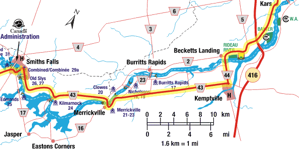
| County Road 43 - Smiths Falls to Kemptville |
base map courtesy Parks Canada
|
|
County Road 43 |
From Smiths Falls head east on County Road 43. Continue east to Merrickville. |
|
Merrickville |
The Village of Merrickville, also known as " The Jewel of the Rideau" is a pretty little village featuring dozens of heritage stone buildings. It's a haven for various artisans with many shops. It is also home to three locks and the largest blockhouse on the Rideau Canal. Plan to spend a bit of quiet time visiting Blockhouse Park. |
|
County Road 43 |
From Merrickville, continue east on County Road 43 to Kemptville. |
|
Burritts Rapids |
Just east of Merrickville, an interesting side trip is to take County Road 23 (River Road) to the Village of Burritts Rapids. On the way to Burritts Rapids you'll pass the locks at Upper and Lower Nicholsons. An interesting stop just before the Nicholsons locks is the old McGuigan Cemetery, located at at 448 River Road. From Burritts Rapids you can continue east on either County Road 2 (north side of the Rideau River) or River Road (south side of the Rideau River) to County Road 44, and then south to Kemptville.
|
|
Kemptville |
Kemptville is a small town, offering various services such as gas and restaurants. |
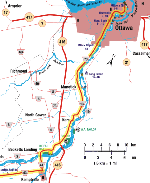
| Kemptville to Ottawa |
base map courtesy Parks Canada
|
| NOTE: In 2012 the route from Kemptville to Kars was changed to follow the east shore of the Rideau River (Cty. Rd. 19) - so the following directions are a bit different than the map (but match the on-road signage) |
|
County Road 43 |
Continue east from Kemptville on Cty. Rd. 43 to Cty. Rd 19 |
|
County Road 19 |
Turn left (in the roundabout) to Rideau River Road (County Road 19). Follow County Road 19 north to County Road 6 |
|
County Road 6 |
Turn left onto County Road 6 (Roger Stevens Drive) and follow it across the bridge over the Rideau River to the junction with County Road 13 (Rideau Valley Drive N.). |
|
Kars |
Take time for a short detour into Village of Kars (now part of Ottawa) is a sleepy little village nestled on the shores of the Rideau River. It features interesting heritage architecture. |
|
County Road 13 |
From Roger Steven's Drive turn right on County Road 13 (Rideau Valley Drive North) and follow it to Manotick. If you're coming from Kars then go north on County Road 13 to its junction with County Road 6 (Roger Stevens Drive), turn left and follow to the junction of Cty. Rd. 13 and turn left (north) onto Cty. Rd. 13. |
|
Manotick |
The Village of Manotick (now part of Ottawa) hosts the historic Watson's Mill, now a museum open to the public. |
|
County Road 13 |
From Manotick, head north on County Road 13 to its intersection with County Road 73. |
|
County Road 73 |
More of a merge than a turn, head north on County Road 73 towards Ottawa. Continue north to Hogs Back Road |
|
Hogs Back |
A visit to the locks at Hogs Back is always interesting. Turn right on Hogs Back Road. You'll find plenty of parking just past Hogs Back in either Hogs Back Park or Mooneys Bay Park. A lovely place to stretch your legs.
|
|
County Road 73 |
Continue north on County Road 73 to Heron Road |
|
Prince of Wales Drive |
Continuing north across Heron Road, the road now becomes Prince of Wales Drive. Continue north to Dows Lake. Dows Lake provides an opportunity to rent a boat and paddle the Rideau Canal in Ottawa |
|
Ottawa |
While the route officially ends at Dows Lake you are now in Ottawa where there are lots of things to do and see. Be sure not to miss the beautiful flight of the 8 Ottawa locks, now nestled between the Parliament Buildings and the Chateau Laurier Hotel |
 The following are driving directions for the Rideau Heritage Route going from Kingston to Ottawa. If starting at the Ottawa end, simply read the listing in reverse.