
ECOLOGY TOUR - Northern Rideau
The Rideau Corridor is a host to several different ecosystems. The central portion of the Rideau is underlain by rocks of the Canadian Shield, known as the Frontenac Axis. This shield terrain is characterised by rocky ridges and a series of lakes (the Rideau Lakes). To the south and north of the Frontenac Axis are flat lying sedimentary rocks (limestone, sandstone, and shale). This gentle terrain makes for ideal farming country, and the Rideau Waterway in this area is made up of rivers; the Rideau River in the north and the Cataraqui River in the south. Newboro represents the top of the watershed, with water to the south of Newboro, being part of the Cataraqui Watershed, flowing into Lake Ontario and the water to the north of Newboro being part of the Rideau Watershed, flowing into the Ottawa River.
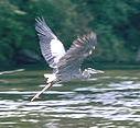 A new ecosystem was formed with the building of the Rideau Canal in 1826-1832. Some sections of the Cataraqui River were turned into lakes, old marshes were drowned, new marshes were created, and several low lying forested areas were flooded. In the central lakes area, the flooding of forested land created a haven for Largemouth Bass, leading to one of the most spectacular bass fisheries in North America by the late 1800s. On the Rideau today, you can spot many species of birds, including Ospreys and Blue Herons, several species of frogs and turtles (always a favourite with the kids), darting dragonflies, muskrats and beavers, and even the occasional otter. The central lakes host healthy populations of Loons and dozens of species of fish abound in both the lakes and rivers. A new ecosystem was formed with the building of the Rideau Canal in 1826-1832. Some sections of the Cataraqui River were turned into lakes, old marshes were drowned, new marshes were created, and several low lying forested areas were flooded. In the central lakes area, the flooding of forested land created a haven for Largemouth Bass, leading to one of the most spectacular bass fisheries in North America by the late 1800s. On the Rideau today, you can spot many species of birds, including Ospreys and Blue Herons, several species of frogs and turtles (always a favourite with the kids), darting dragonflies, muskrats and beavers, and even the occasional otter. The central lakes host healthy populations of Loons and dozens of species of fish abound in both the lakes and rivers.
In the central Rideau, you will find a blend of hardwood forests, featuring oak, beech, birch, elm, ash and maple trees and coniferous forests, with white pine and spruce. In many areas the white pine tower above the rest of the trees, their wind swept branches a symbol of Canada's natural landscape.
There are many ways to enjoy the ecological diversity of the Rideau. In addition to driving trips, take the opportunity to bring along your boat, or rent one at places like Chaffey's Lock or Portland, and spend a day or two on the water, puttering through the back bays, enjoying the diversities of the natural Rideau habitats.
Those contemplating several visits to the various conservation areas will be interested in obtaining an annual pass, which will allow you unlimited visits during the season to the conservation areas within a single district (Rideau or Cataraqui).
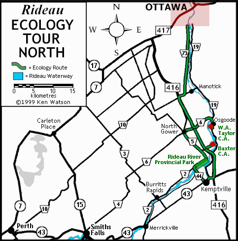
ECOLOGY TOUR NORTH
There are two conservation areas and a provincial park located close together in the northern Rideau region. These allow you to get out of the urban jungle that is Ottawa and enjoy a variety of natural settings along the Rideau. The conservation areas are maintained by the Rideau Valley Conservation Authority
Ottawa via Cty Rd. 73 to Hwy 416 to Kars exit - There is a choice of either a small conservation area for a picnic or to use the boat launch to explore the Rideau River, or a larger conservation area with trails, a beach and displays.
The smaller area is the W.A. Taylor Conservation Area which is found by taking Cty. Rd. 6 (Kars exit) east to Cty. Rd. 19, turning south towards Osgoode and keeping a lookout for the signs directing you to the W.A. Taylor Conservation area. W.A. Taylor features a boat launch, picnic tables and a washroom facility.
The other option is to stay on Hwy. 416 and exit east onto Dilworth Road. Follow Dilworth Road for about 3 km to the Baxter Conservation Area. Baxter features an Interpretive Centre, walking trails, picnic tables, a beach, a wildflower meadow, and washrooms. Although there is no boat launch, canoes and cartop boats can be easily launched into the river. Baxter is open year-round. A feature of the conservation area is the Filmore R. Park Nut Grove featuring 30 nut and bean bearing trees. Baxter also features weekend programs including a March break program and summer Nature Day Camps for kids.
Kars to Rideau River Provincial Park - Those who wish to do more than a day trip will wish to continue on to Rideau River Provincial Park, located on the northwest side of the Rideau River, just east of Becketts Landing. Depending on which conservation area you are coming from, head south on Cty. Rd. 19 (or from Ottawa just keep south on Hwy. 416) and turn right (west) onto Cty. Rd. 43. At Kemptville, turn north on Cty. Rd. 44, crossing the Rideau River and turn right on Cty. Rd. 2, Rideau River Provincial Park is less than a kilometre down the road. The park has 186 campsites, 31 with electricity. It features a forested area with silver maples and pines, sandy beaches, playgrounds, washrooms, showers, and picnic areas. It operates from May to September.
Rideau River Provincial Park to Ottawa - once you have finished enjoying your stay, head north to North Gower and then pick up Hwy. 416 into Ottawa.

|