Your location: Rideau Canal Home Page > Paddling the Rideau Canal > Geology of the Rideau Canal
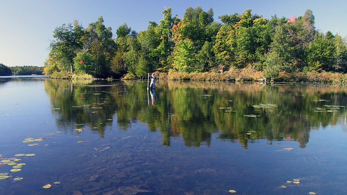
Rock Dunder, part of the Lynhurst Pluton, rises over Morton Bay
Did you know that whales once swam in an ocean sea where Ottawa sits today?
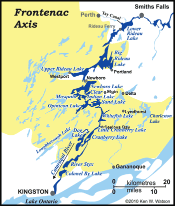 As you travel along the Rideau Canal, the route you follow is defined by its geology. The area is underlain by part of an old mountain range, the Grenville Mountains, eroded down over many millions of years. Much of this eroded mountain range has been covered by younger sedimentary rocks, but portions of the old mountains are exposed, partly a result of their original topography and partially due to the eroding away of younger overlying rocks. This area is known as the Frontenac Axis. In essence, if you boat from Kingston to Smiths Falls, you'll be boating over a (very old) mountain range. As you travel along the Rideau Canal, the route you follow is defined by its geology. The area is underlain by part of an old mountain range, the Grenville Mountains, eroded down over many millions of years. Much of this eroded mountain range has been covered by younger sedimentary rocks, but portions of the old mountains are exposed, partly a result of their original topography and partially due to the eroding away of younger overlying rocks. This area is known as the Frontenac Axis. In essence, if you boat from Kingston to Smiths Falls, you'll be boating over a (very old) mountain range.
The Frontenac Axis can be thought of as a ridge connecting the extensive area of the Canadian Shield to the north and the Adirondack mountains to the south. On the Rideau, the southern irregular boundary of the Frontenac Axis is near Kingston Mills and the northern irregular boundary is on the northern reaches of Big Rideau Lake. The Frontenac Axis is made up of rocks formed 1.35 to 1.06 billion years ago (Precambrian: middle to late Proterozoic age) and then deformed and metamorphosed 900 million years ago. The rock types that you'll be able to see as you travel through the Frontenac Axis include granite, syenite, monzonite, migmatite, gabbro, quartzite, marble, gneiss and pegmatite. Many of the lakes are underlain by marble (crystalline limestone) which provides some buffering against acid rain.
The metamorphism occurred during a mountain building event as the proto-North American continental plate collided with the proto-South American plate. The mountains, known in this area as the Grenville Mountains, that were built as a result of this continental collision were analogous to the Himalayan or Andes mountain ranges today (really big!). They extended from Labrador to California and into Mexico.
When the collision stopped, the mountain building came to an end and ever-present erosion started to wear them down. Erosion changed to deposition when continental drift brought the eroded remnants of our part of the mountain range to the area of the equator, where, 520 to 460 million years ago (Paleozoic: Cambrian to Lower Ordovician age), a shallow sea deposited new marine sediments on top of these older rocks. This shallow sea was located near the equator at that time (part of Laurentia which eventually became part of North America due to continental drift). These sediments turned into the limestone, sandstone, dolomite, shale and conglomerate that we can see today on either side of the Frontenac Axis.
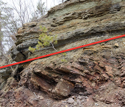 |
| Elgin Unconformity
The red line in the photo shows where there is an almost 500 million year gap between the overlying Cambrian sandstones and the underlying Precambrian gneisses. This gap is the erosional period during which the once mighty Grenville mountains were eroded down to a mere remnant of their former glory, known in this area as the Frontenac Axis. This outcrop is located on Highway 15 just outside the Village of Elgin. |
In the southern part of the Rideau, the younger rocks near Kingston are dominated by limestone. In the centre part of the Rideau, on the margin of the Frontenac Axis, the younger sedimentary rocks tend to be dominated by sandstone. In the northern part of the Rideau, from Smiths Falls to Ottawa the sedimentary rocks are mostly dolomite, limestone and shale.
The Frontenac Axis is exposed today because it represents a topographic high – the remains of the highest part of the original mountains. The thickness of sediments deposited over these higher parts of the old mountain range was less than on either side and this allowed those sediments to be eroded away, exposing these old rocks.
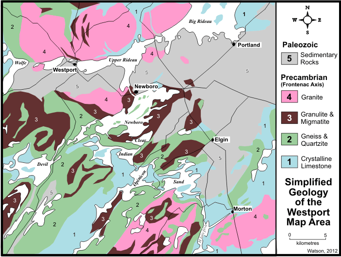 |
This highly simplified geology map shows some of the contact area between the Frontenac Axis
(units 1, 2, 3 and 4) and the younger sedimentary rocks (unit 5) in the central Rideau area.
Map adapted from GSC Map 1182A by H.R. Wynne-Edwards, GSC Memoir 346, 1967.
|
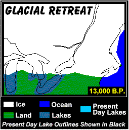
More recently, three events have impacted on the landscape - the ice last age, glacial Lake Iroquois and the Champlain Sea. During the last ice age, which peaked about 20,000 years ago, the Rideau area was covered by ice up to 1.5 kilometres (1.0 mi) thick. The ice polished and moved rocks, excavated some of the landscape and left large deposits of sand and gravel. The weight of the ice depressed the landscape by about 175 m (575 ft) below where it is today.
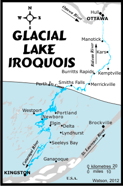
By 14,000 years ago, the climate began to warm up, melting the glaciers and forcing them to retreat. In the area of Lake Ontario, today's exit of the lake down the St. Lawrence River was blocked by ice and a large lake, about 30 m (100 ft) higher than today's Lake Ontario, formed. That lake, known as Lake Iroquois, extended as far north as Perth and Smiths Falls.
Evidence of that lake exist today in form of glaciolacustrine (a big word for glacial lake) deposits. These include near shore sediments such as gravel and gravelly sand, and deeper water deposits such as silt and clay. These deposits are found all over the southern Rideau, including on heights of land, such as near the top of Rock Dunder. This is because the overall landscape was depressed, and features such as Rock Dunder formed part of the bottom of this large lake.
By about 13,350 years ago a channel opened up in the ice dam (near Rome, NY), rapidly draining much of the lake. At the same time the land was rising as the weight of the ice was removed (this rising is called "isostatic rebound").
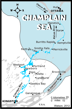
As Lake Iroquois and subsequent glacial lakes were getting smaller, the glaciers were continuing their retreat from the St. Lawrence lowlands. About 13,000 years ago this allowed waters from the Atlantic Ocean to mix with glacial melt-waters and river drainage to create a brackish sea known as the Champlain Sea which extended past (west and south) of Ottawa.
The southern limit of this sea on the Rideau Canal was near Nobles Bay of Big Rideau Lake. If you were paddling the sea back then, you would have been enjoying it in the company of whales. The bones of a humpback whale were found near Smiths Falls and beluga (white) whale bones have also been found in Champlain Sea deposits. This sea retreated as the glaciers moved north and the land continued to undergo isostatic rebound. By about 11,100 years ago, the central Rideau had risen above sea level and the land that we see today was being revealed. Rivers and streams continued to modify the landscape up until the building of the Rideau Canal.
There are a some interesting geological features in the Ottawa area. The northern part of the Rideau River is the youngest part of the waterway (outside of canal altered sections) since, in the immediate post-glacial period, the Ottawa River had a channel to the south of where it is today, across much of urban Ottawa to the Mer Bleue area (where the trace of the old Ottawa River channel can be clearly seen). It eventually shifted north (due to isostatic rebound) to its present location and cut a deep channel. The faster excavation by the Ottawa River, through the underlying limestone rocks, compared to the Rideau River, formed Rideau Falls.
Another geological feature at Ottawa is that much of the area is underlain by a thick clay layer, a type of "quick clay" known locally as Leda clay (named after a type of small clam found in the clay deposits). Quick clay is a clay that is not well bonded and is subject to liquefaction, that is, when vibration is induced, it can turn into a liquid and flow. When undisturbed, it looks and acts like a normal solid form of clay. It was formed by glacial silt settling out on the bottom of the Champlain Sea. There it formed a stable type of marine clay, "glued" with salt. When the sea retreated due to the rising land, this clay was exposed to rainfall that removed much of that salt bonding, creating the unstable clay that is present in much of the region today. Earthquakes can cause this clay to liquefy, leading to landslides. Ottawa is a seismically active region (earthquake prone) and, in the future, an earthquake is going to play havoc with the city (if I lived in Ottawa, I'd check to see if my house is sitting on bedrock or on clay).
Mining in the Rideau Region
No large scale mining has ever been conducted in this region, but many small, short term operations at various times mined a variety of minerals including; galena, magnetite, hematite, mica, apatite, graphite, barite, celestite, quartz crystals, feldspar, building stone, and gravel.
Galena (lead sulphide) was mined near Lyndhurst in the mid to late 1800s. A couple of very small scale operations mined barite, and several mined celestite (strontium sulphate).
Iron was mined in several localities. From 1850 to the early 1880s, iron, in the form of titaniferous magnetite, hosted by gabbro, was mined near Newboro Lake (Chaffey Mine and Matthews Mine - see photo of Chaffey Mine below). Some small scale mining of hematite (iron ore), starting as early as 1810, was done near Delta. The original mine supplied a smelter at Furnace Falls (now Lyndhurst).
Phosphate (Apatite) - there are many small deposits of apatite which have been mined. Apatite was a prime source of phosphate for fertilizer (most was shipped to England) prior to 1890. Phosphate mining started in the Rideau area in about 1867 and continued to the early 1890s. The largest phosphate mine was the Opinicon Rock Lake mine which operated from 1888 to 1892 (see photo below).
Mica was also mined from several localities. It often occurs with apatite, so some of the apatite mines produced both products. The main mica mines were the Sand Lake mine, which opened in 1870 and was mined intermittently until 1912, and the Stoness mine, near Buck Lake which mined mica from 1894 to 1902.
 |
|
 |
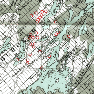
Phosphate Mines
The location of small scale phosphate mines in the area of Big Rideau Lake.
Section of a map from "Phosphate in Canada" by Hugh S. Spence, Canada Department of Mines, 1920.
|
|
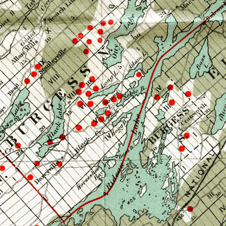
Mica Mines
The location of small scale mica mines in the area of Big Rideau Lake.
Section of a map from "Mica" by H.S. Spence, Canada Department of Mines, 1929.
|
Graphite was mined intermittently in the Timmins Mines, north of Big Rideau Lake, from 1918 to 1923.
Quartz crystals were mined near Black Rapids (Lansdowne Township), starting in 1943. The crystals are found in vugs, some up to a foot long and doubly terminated.
Granite was mined from several quarries. Some attractive pink and red quartz monzonite was mined (known as Lyndhurst Rose Granite and Rideau Red Granite). Unfortunately, much of this rock contains inclusions and irregular fractures, and the amount of waste in the mines could be high at times.
Sandstone was quarried for use in building the Rideau Canal. For instance, the locks and dams at Jones Falls, Davis, and Chaffeys were built from sandstone quarried near Elgin. The churches in Elgin are also built of this material.
Limestone was also used in the construction of Rideau Canal locks and dams. Much limestone was also quarried for the use in constructing stone houses, particularly near Ottawa and near Kingston. The latter has so many buildings made of limestone that it is known as the "Limestone City".
Today, mining in the region is mostly surface quarrying for sand, gravel, and stone.
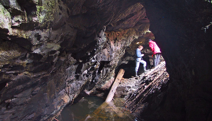
Inside the Opinicon Rock Lake Mine
James Bell of Arnprior mined 500 tons of phosphate from this deposit in 1888 and 1889. The Kingston Phosphate Company mined the property in 1891 and 1892. An inclined pit 75 feet long was sunk on a 45 degree incline to 255 feet. The mine is now flooded at a depth of about 50 feet. In total, about 1500 tons of phosphate was produced. |
Chaffey Mine - Iron Island, Newboro Lake
A causeway (seen just underwater in the foreground in this photo), linked this island to the mainland. In 1850, the Chaffey brothers; John, Benjamin and Elswood, started mining iron, contained in titaniferous magnetite. They shipped about 340 tons of iron ore that year to Kingston. Sir William Logan of the Geological Survey reported that the Chaffey brothers had mined 2,000 tons of iron ore from this deposit in 1858 and 4,000 tons in 1859 and shipped it, via the Rideau Canal and Lake Ontario, to Pittsburgh. The mining was done from four small pits, now filled with water.
In about 1860, a second iron mine, the Matthews Mine (also known as the Yankee Mine), was opened by Frank and Eugene Fifield on the mainland about 800 metres north of Iron Island. It consisted of a single open pit 300 feet long by 100 feet wide by 40 feet deep.
There are no definitive figures on the total amount mined from these two mines. In 1871 it was reported that a crew of 12 men had mined 3,500 tons from the Chaffey mine that year. That same year, at the Matthews Mine, a crew of 15 men mined 4,000 tons. This ore at this time was being shipped to Cleveland, Ohio. The mineralization was low grade for the era (52% iron) and was only economic due to its location on the Rideau Canal, which allowed for direct on-water shipping to market. By 1885 both mines had closed.
|
|
Comments: send me email: Ken Watson
©1996- Ken W. Watson
|