ABOUT WESTPORT
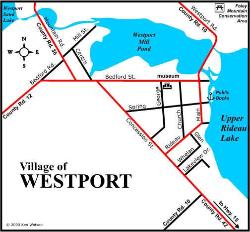
Westport, a quiet little village with a population of about 600, is a very popular destination spot for tourists due to the number of interesting shops in the town. Whether you come by boat or by car, you will find that Westport caters to most of your needs. Situated at the head of Upper Rideau Lake, Westport has rolling farmland to the south and more rugged terrain, in the form of Foley Mountain, to the north. In addition to public docking facilities, Westport offers a full range of land-based accommodations. Boaters will find a large area of public docks with easy access into town.
There is a lot to do and see in Westport. There are many interesting shops, two local golf courses and swimming beaches. The nature enthusiast will want to visit Foley Mountain Conservation Area, which offers a great view of Westport, as well as provides for many opportunities for hiking and nature viewing. The Rideau Trail, extending from Kingston to Ottawa, runs through the Foley Mountain Conservation Area.
Events in Westport include the annual "MusicWestport" held on the third Saturday in August.
HISTORY
The first settlers to the Westport area arrived in the period between 1810 and 1820. The land on which Westport now sits was originally granted by the Crown to a Mr. Hunter, but he never settled in the area, and it passed through several hands before being purchased by Reuben Sherwood in 1817. Some of this land was later purchased by the Stoddard and Manhard families. The small community that was beginning to grow was known at that time as Head of the Lake due to its location at the head of Rideau Lake. In 1828, Stoddard built a saw mill and in 1829 the Manhards built a saw mill and grist mill. It became known at that time as Manhard's Mills.
It was two local merchants, Aaron Chambers and Lewis Cameron, who in 1841, named the village Westport, the name reflecting its location at the west end of Upper Rideau Lake. The village of Westport was incorporated in 1904.
Westport remained a thriving commercial centre through the 19th century and into the 20th century. The building of the Rideau Canal allowed goods to be shipped north to Ottawa and south to Kingston by water. In 1882, an entrepreneur named R.G. Harvey proposed an ambitious project to build a railway from Brockville to Sault Ste. Marie. The project ran out of money after the section from Brockville to Westport had been completed in 1888. The Brockville-Westport line (B&W) moved goods, mail and people to and from the St. Lawrence and Westport. The rail line also brought tourists north to Westport, starting a now century-old tradition of Westport as a tourist destination. The last train travelled the B&W line in 1952.
|