Your location: Rideau Canal Home Page > Rideau Lockstations > Upper Nicholsons Lock 19
| UPPER NICHOLSONS Locks 19 |
|
|
| Number of locks: 1 |
Total Lift: 2.4m ( 8 ft.) |
Lock Through Time: 15 min.* |
| Chart No: 1512 (Sheet 3) |
GPS:1 N 44° 57.070' W 75° 49.050' |
| Chart Sales: No |
Lockstation Tel: 613-269-4631 |
| Washrooms: Yes2 |
Drinking Water: Yes3 |
Day Use Docking: No |
| Overnight Mooring: Yes |
Docking4 Upstream: 37m/120' |
Docking4 Downstream: Note 1 |
| Ice: No |
Power: No |
Boater Camping:5 Yes |
| Boat Launch: No |
Picnic Tables: Yes |
BBQ Grills: Yes |
| Parking: Yes |
Public Telephone: No |
Self Guided Trail: No |
| Hwy Access: off River Rd. (Hwy. 23). |
Lock Connects: Rideau Canal Cut to Rideau Canal Cut |
| Civic Address: 121 Andrewsville Road, Merrickville-Wolford, Ontario |
| Special Notes: To ensure passage, boaters must arrive at least 30 minutes prior to closing. There is a swing bridge with a clearance of 3.6m (11.7 ft). The bridge swings on demand. |
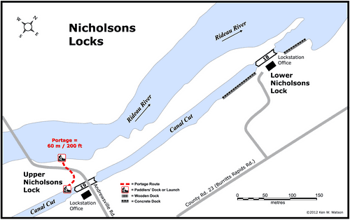
| Of Interest: Nicholsons, Upper and Lower, consists of two locks separated by an excavated channel, which bypass a set of rapids in the Rideau River. Upper Nicholsons features one of four remaining Unequal Arm, Center Bearing timber swing bridges on the Rideau. Just up the road from Upper Nicholsons you’ll find McGuigan’s Cemetery (448 County Road 23, aka Burritts Rapids Road), one of the oldest burying grounds on the Rideau. There you will find the beautiful poignant headstone of Margaret Davidson, the 2 year old daughter of one of the contractors for Clowes Lock, who died in 1829. Near Upper Nicholson’s you’ll also find an osprey nest (usually with an osprey in residence), located top of a hydro pole specifically erected for the nest. |
Notes: There is no gas in the immediate vicinity (closest is at Merrickville). Upper and Lower Nicholsons are separated by 400 m (1,300 ft.) of canal cut.
Parks Canada has two oTENTiks (canvas topped A-frame cabins) at this location available for rent |
|
* Time to actually go through the locks. Allow at least twice this time when trip planning. See Schedule Caveats.
1) GPS data should not be used for navigation. See the GPS page.
2) Washrooms are wheel chair accessible.
3) Unless indicated otherwise, water at the lockstation is potable
4) Includes both blueline and greyline docking - see Lockstation Docking Page.
5) Allows tent camping for those arriving by water and also for cyclists and hikers.
Note 1: 180' of blueline docking available during lock operating hours between U & L Nicholsons
|
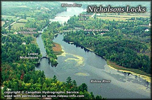 |
Nicholsons Locks looking SouthwestThe two locks at Nicholsons are located in a canal cut on the east bank of the Rideau River. It's a pretty trip through the cut, especially the white wood swing bridge over the lock at Upper Nicholsons.
photo copyright © Canadian Hydrographic Service - used with permission |
Comments: send me email: Ken Watson
©1996- Ken W. Watson
|