Your location: Rideau Canal Home Page > Rideau Lockstations > Burritts Rapids Lock 17
| Number of locks: 1 |
Total Lift: 2.7m ( 9 ft.) |
Lock Through Time: 15 min.* |
| Chart No: 1512 (Sheet 3) |
GPS:1 N 44° 58.950' W 75° 47.190' |
| Chart Sales: No |
Lockstation Tel: 613-258-4510 |
| Washrooms: Yes2 |
Drinking Water: Yes3 |
Day Use Docking: Yes |
| Overnight Mooring: Yes |
Docking4 Upstream:
81m/265' |
Docking4 Downstream:
85m/280' |
| Ice: No |
Power: Yes |
Boater Camping:5 Yes |
| Boat Launch: No |
Picnic Tables: Yes |
BBQ Grills: Yes |
| Parking: No |
Public Telephone: No |
Self Guided Trail: Yes |
| Hwy Access: off River Rd. (Hwy. 23) |
Lock Connects: Rideau River to Rideau River |
| Civic Address: 673 River Road, North Grenville, Ontario |
| Special Notes: To ensure passage, boaters must arrive at least 30 minutes prior to closing. Swing bridge located 1 km upstream with clearance of 3.2m (10.4 ft.). Bridge swings on demand. |
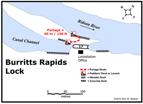
| Of Interest: An interesting construction feature here is that the lock is built at the bottom of end of a ravine, a “snie” (dry flood channel) that today forms the navigation way for the Rideau Canal, bypassing the rapids in this location. Many Rideau locks took advantage of natural features such as these natural flood channels to both speed up and reduce the cost of canal construction. The water control dam is located at the head of the island, diverting water into this channel. You can walk the entire length of the island on the Tip to Tip Trail (a pleasant 2 hour stroll). It makes for a nice relaxing journey, especially if you stop to take in the historic village of Burritts Rapids. |
| Notes: Gas is available several km downstream at Pirate Cove Marina. |
|
* Time to actually go through the locks. Allow at least twice this time when trip planning. See Schedule Caveats.
1) GPS data should not be used for navigation. See the GPS page.
2) Washrooms are wheel chair accessible.
3) Unless indicated otherwise, water at the lockstation is potable.
4) Includes both blueline and greyline docking - see Lockstation Docking Page.
5) Allows tent camping for those arriving by water and also for cyclists and hikers.
|
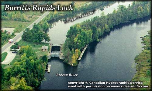 |
Burritts Rapids Lock looking SouthwestThe lock marks the eastern end of the canal channel constructed to bypass the rapids. This is the more "typical" type of canal design, a canal channel bypassing the rapids with a dam placed at the head of the rapids to provide for navigation depth above the lock. At many spots on the Rideau, Colonel By used a "slackwater" design that placed a dam at the bottom of the rapids, raising the water and drowning the rapids. This was often much faster and cheaper than excavating a channel around the rapids. In the case of Burritts, the use of an existing natural flood channel known as Oxford Snie made bypassing the rapids a relatively easy chore.
photo copyright © Canadian Hydrographic Service - used with permission |
Comments: send me email: Ken Watson
©1996- Ken W. Watson
|