ABOUT BURRITTS RAPIDS
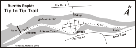
Burritts Rapids is a quiet little community, one of the first established on the Rideau. The village itself is on a small island, although you'll find the Church and several residences located on the north shore. A feature of the island is the Tip to Tip Trail - a brochure detailing this trail is available at the Burritts Rapids lockstation (it can also be downloaded from this website by going to the Documents Page.)
HISTORY
Burritts Rapids was one of the first settlements on the Rideau, predating the Canal itself. In 1793, Colonel Stephen Burritt, floated down this section of the Rideau River on a raft looking for a good spot to settle. At Burritts Rapids he saw the water power potential for a mill and settled there with his wife Martha (Stevens) and their two-year old son Henry. Their second son, Edmund, was born here on 8 Dec 1793.
The story goes that, soon after settling there, they were dying from a fever when they were rescued by a band of local indigenous people, nursed back to health, and even had their crops harvested for them. Ever after, the Burritt home was a welcoming place for indigenous people travelling the Rideau.
When Colonel By came through in 1826, Burritts Rapids was a thriving village with several businesses. The first townsite was laid out in 1830 and a post office, with the name "Burritt's Rapids" was established in 1839. In the 20th century, the name was changed to "Burritts Rapids" and today, both the community and lockstation are known by that name. The village, like the Rideau Canal itself, lost its commercial importance at the start of the 20th century.
The fixed bridge at the north end of town (over the original Rideau River) is in the location where one of the earliest bridges across the Rideau was built in 1824 (it has since been rebuilt at least twice, in 1920 and 1983). Just upstream of that bridge a mill dam was erected (as early as 1845). It crossed the entire channel, with a waste weir at the south end and served a saw mill and a grist mill (both located on the south side of the river). The remains of this dam can still be seen today.
In about 1832, a timber high level fixed bridge was constructed across the channel of the canal (south end of town), just upstream of the present day swing bridge. By the early 1850s, it had been replaced by a timber swing bridge in the location of the present steel truss swing bridge (which dates to 1897 - extensively renovated in 2017/18). The swing bridge is opened by turning a crank in the pivot at one end of the bridge. Counter weights and a set of roller wheels mounted on a circular track underneath allow the bridge to be swung with little effort.
To the north of island, on County Rd 2 (Donnelly Drive) is the historic Christ Church, one of the earliest churches on the Rideau. An Anglican congregation was formed in about 1822, but had no fixed place of worship. In 1830 Daniel Burritt donated land for a church and a burying ground. Construction was started in 1831 and completed in 1832. In 1834 the church was consecrated as Christ Church by the Right Reverend Charles James Stewart, Bishop of Quebec.
To learn more about this charming village and the countryside, visit the lockstation and take a stroll down the Tip-to-Tip Trail.
|