Your location: Rideau Canal Home Page > Rideau Lockstations > Jones Falls Locks 39-42
| Number of locks: 4 (incl. 3 in flight) |
Total Lift: 17.8m ( 58.4 ft.) |
Lock Through Time: 1 hour* |
| Chart No: 1513 (Sheet 4) |
GPS:1 N 44° 32.760' W 76° 14.300' |
| Chart Sales: Yes |
Lockstation Tel: 613-539-6081 or 613-507-3185 |
| Washrooms: Yes2 |
Drinking Water: Yes3 |
Day Use Docking: Yes |
| Overnight Mooring: Yes |
Docking4 Upstream:
104m/340' |
Docking4 Downstream:
55m/180' |
| Ice: No |
Power: No |
Boater Camping:5 Yes |
| Boat Launch: Yes |
Picnic Tables: Yes |
BBQ Grills: Yes |
| Parking: Yes |
Public Telephone: Yes |
Self Guided Trail: Yes |
Hwy Access: 4 km W. of Hwy. 15
on Jones Falls Rd (Cty Rd. 11) |
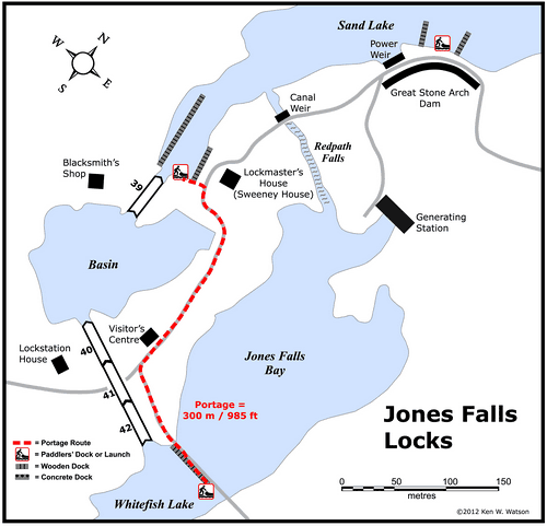
Locks Connect: Whitefish Lake to Sand Lake |
| Civic Address: 182 Lock Road
Rideau Lakes, Ontario |
| Special Notes: To ensure passage, boaters must arrive at least 2 hours prior to closing.
|
| Of Interest: One of the prettiest lockstations on the Rideau, Jones Falls is home to the “Great Stone Arch Dam.” When completed in 1831, this was the highest dam in North America (almost 60 feet), a stunning feat of engineering, still very impressive to this day. The defensible lockmaster’s house, known as Sweeney House after the first lockmaster, Peter Sweeney, is open for interpretation. The blacksmith’s shop, built in the 1840s, often has a blacksmith on duty, more than willing to explain his craft. |
| Notes: Gas is available upstream at Sand Lake Marina or downstream at Seeleys Bay. Limited services are available from the Hotel Kenney (including docking with power). |
|
* Time to actually go through the locks. Allow at least twice this time when trip planning. See Schedule Caveats.
1) GPS data should not be used for navigation. See the GPS page.
2) Washrooms are wheel chair accessible.
3) Unless indicated otherwise, water at the lockstation is potable.
4) Includes both blueline and greyline docking - see Lockstation Docking Page.
5) Allows tent camping for those arriving by water and also for cyclists and hikers.
|
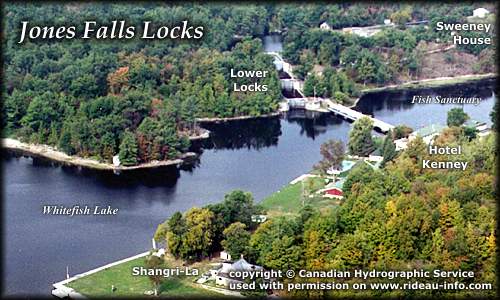 |
Jones Falls Lockstation looking NorthwestOne of the prettiest lockstations on the Rideau, Jones Falls has a flight of 3 lower locks, with a turning basin separating these from the upper lock. At 58.4 feet, this is the highest lift of any lockstation on the Rideau. There is lots to see at Jones Falls so plan on stopping for awhile.
photo copyright © Canadian Hydrographic Service - used with permission |
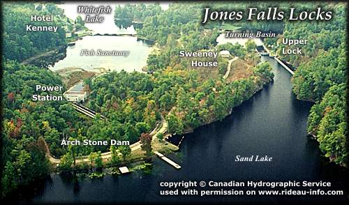 |
Jones Falls Lockstation looking SouthVisitors heading to the upper lock often miss the spectacular arch stone dam that was built to tame the mile long series of rapids and falls that led out of Sand Lake. A tremendous engineering feat for the day (1830), it still stands today for the most part exactly as originally built (you may have guessed that the power station and weir is not part of the original structure). Take a few moments from your journey to stop and have a look.
photo copyright © Canadian Hydrographic Service - used with permission |
Comments: send me email: Ken Watson
©1996- Ken W. Watson
|