Your location: Rideau Canal Home Page > Rideau Canal Statistics
Statistics of the Rideau Canal
For all you number hounds out there, here are the statistics on
the Rideau Canal System. Please note that in most cases I've separated out the Tay Canal (Beveridges Locks) from the Rideau Canal. On this page you will find information about general Rideau Canal Statistics, information about Rideau Route Statistics, and information about 2015 and 2014 Vessel Passage Statistics.
Rideau Canal Statistics
| Lock Dimensions (1) | 41 metres/134 feet long by 10 metres/33 feet wide |
| Available Water Depth (2) | 1.5 metres/5.0 feet (minimum) |
| Minimum Bridge Clearance (3) | 6.7 metres/22.0 feet (minimum) |
| Total Locks (Kingston - Ottawa) | 45 (47 including the 2 locks on the Tay Canal)
|
| Total Lockstations | 23 (24 including Beveridges on the Tay Canal)
See "How the Locks Are Counted" below |
| Total Distance (Kingston - Ottawa) (4) | 202 kilometres/125.6 miles
|
| Total Distance of Artificial Channels | 19 kilometres/12 miles
|
| Lift - ascending Ottawa to Upper Rideau Lake | 83.8 metres/275 feet (in 31 locks)
|
| Lift - descending Upper Rideau to Kingston | 50.6 metres/166.2 feet (in 14 locks)
|
| Maximum Size of Vessel (5) | 27.4 m/90 ft. length, 7.9m/26 ft. width, 6.7m/22ft height
|
| Transit Time (one way) | 4 to 6 days |
| Maximum Depth of Water | 100.3 metres (329 feet) |
(1) This is the full length of the lock from the point of the upper sill to the point of the lower sill. The lock is actually 124 feet (37.8 m) long in the chamber, measured from the point of the lower sill to the face of the breastwork. The lower gates require 13 feet (4.0 m) of room for their swing, so a vessel must be less than 111 feet (33.8 m) long. Since the walls of the lock slope inwards, the internal width at the lower navigation water level in the locks is 31.5 feet (9.6 m).
(2) Normally the locks are maintained with a draught of 1.7 metres
(5.5 feet). However even the 5 foot minimum is subject to water availability and all vessels with a draught of over 1.2 metres (4 feet) should contact the Rideau Canal Office prior to traversing the canal.
(3) This is the minimum fixed bridge clearance on the Rideau Canal proper. On the Tay Canal, the Craig Street fixed bridge, at 2.1 metres/7 feet limits boats going right into downtown Perth (larger boats can tie up at Last Duel Park near downtown).
(4) Distances reflect the Rideau Canal proper. The Tay Canal, which is connected to the Rideau, extends from Lower Rideau Lake to Perth, a distance
of 10.0 kilometres (6.2 miles). Two locks (Beveridges #33 & Beveridges #34)
raise boats a total of 7.0 metres (22.9 feet) into the Tay Canal.
(5) The Canal used to allow boats with a length of 33.5 metres
(110 feet) and a width of 9.1 metres (30 feet) width to traverse
the system. If your vessel is less than these dimensions, but greater
than the maximum shown in the chart, contact the Rideau Canal Office
.
How the Locks Are Counted
When the canal was opened in May, 1832, there were 47 masonry locks that provided navigation from Kingston to Ottawa. In reality, only 46 locks actually provided the navigation since one of the two locks at Hogs Back was (and still is) a guard lock (a flood guard, it normally doesn't provide any lift). But that is picking nits, so we'll leave the count at 47. In the late 1880s, two locks (Beveridges) were constructed at the entrance to the Tay Canal. Although not part of the Rideau Canal proper, they are administered by the Rideau Canal Office - so although the number of locks required for Kingston to Ottawa navigation didn't change, administratively, 2 more locks were added (total 49). In the 1970s, a new single lock (29a) replaced the flight of 3 Smiths Falls Combined locks. This reduced the actual number of Kingston to Ottawa navigation locks to 45 and the total locks administered by the Rideau Canal Office to 47. This is the situation today.
In terms of Lockstations, the present day Kingston to Ottawa navigation lockstations number 23 - they are: Ottawa (8 locks in flight), Hartwells (2 locks in flight), Hogs Back (1 lift lock, 1 guard lock), Black Rapids (1 lock), Long Island (3 locks in flight), Burritts Rapids (1 lock), Nicholsons (2 detached locks), Clowes (1 lock), Merrickville (3 detached locks), Kilmarnock (1 lock), Edmunds (1 lock), Old Slys (2 locks in flight), Smiths Falls Combined (1 lock), Smiths Falls Detached (1 lock), Poonamalie (1 lock), Narrows (1 lock), Newboro (1 lock), Chaffeys (1 lock), Davis (1 lock), Jones Falls (3 locks in flight, 1 detached), Upper Brewers (2 locks in flight), Lower Brewers (1 lock), Kingston Mills (3 locks in flight, 1 detached). The lift statistics for those locks can be seen in the next section.
Parks Canada quotes 24 lockstations since they are counting in the Beveridges (2 detached locks) on the Tay Canal.
Rideau Canal - Route Statistics
The distances shown are following the marked navigation channel (shown on Charts 1512 and 1513).
Distance
km (miles) from
OTTAWA | Distance
km (miles) from
KINGSTON | Description
| Lock Lift
metres (feet) | Bridge Clearance
metres (feet)
| Chart | Boat
Launch
|
|---|
| 0 (0) | 202.1 (125.6) | Ottawa River, Ottawa
| level=40.8m
(134 ft) |
| |
|
| 0 (0) | 202.1 (125.6) | Ottawa Locks #1-8 (in flight)
| 24.1 (79.1) |
| 1512 #1 |
|
| 0.3 (0.2) | 201.8 (125.4) | Bridge - Plaza - Fixed
| | 7.9 (25.6)
| | |
| 0.6 (0.4) | 201.5 (125.2) | Bridge - Mackenzie King - Fixed
| | 8.2 (26.6)
| | |
| 0.9 (0.5) | 201.2 (125.0) | Bridge - Laurier Ave - Fixed
| | 8.2 (26.6)
| | |
| 1.6 (1.0) | 200.5 (124.6) | Bridge - Corktown Footbridge - Fixed
| | 8.2 (26.6)
| | |
| 2.4 (1.5) | 199.7 (124.1) | Bridge - Queensway - Fixed
| | 7.1 (23)
| | |
| 2.6 (1.6) | 199.5 (124.0) | Bridge 1 - Pretoria Ave - Vertical Lift
| | 3 (10) closed - 7 (22.7) open
| | |
| 3.4 (2.1) | 198.7 (123.3) | Bridge - Flora Footbridge
| | 6.7 (22.0)
| | |
| 4.5 (2.8) | 197.6 (122.8) | Bridge - Bank St. - Fixed
| | 8.8 (28.5)
| | |
| 5.5 (3.4) | 196.6 (122.2) | Bridge - Bronson Ave - Fixed
| | 6.7 (22.0)
| | |
| 6.7 (4.2) | 195.4 (121.4) | Hartwells Locks #9-10 (in flight)
| 6.5 (21.5) |
| | |
| 8.2 (5.1) | 193.9 (120.5) | Bridge - Heron Rd - Fixed
| | 8.5 (27.6)
| | |
| 8.4 (5.2) | 193.7 (120.4) | Hogs Back Locks #11-12 (1 lift, 1 guard)
| 4.2 (13.8) |
| | X |
| 8.4 (5.2) | 193.7 (120.4) | Bridge 4 - Hogs Back - Swing
| | 2.9 (9.4)
| | |
| 11.9 (7.4) | 190.2 (118.2) | Bridge - CNR High Level - Fixed
| | 9.5 (30.8)
| | |
| 13.5 (8.4) | 188.6 (117.2) | Bridge - Hunt Club - Fixed
| | >16.0 (>50)
| | |
| 15.0 (9.3) | 187.1 (116.3) | Black Rapids Lock #13
| 2.9 (9.5) |
| | |
| 16.0 (10.0) | 186.1 (115.6) | Park - Echo Lands
| | |
| X |
| 20.7 (12.9) | 181.4 (112.7) | Park - Chapman Mills Conservation Area
| | |
| |
| 21.0 (13.0) | 181.1 (112.5) | Bridge - Vimy Memorial - Fixed
| | 6.7 (22)
| | |
| 23.3 (14.5) | 178.8 (111.1) | Long Island Locks #14-16 (in flight)
| 7.6 (24.9) |
| 1512 #2 |
|
| 23.5 (14.6) | 178.6 (111.0) | Bridge 5 - Long Island - Swing
| | 1.1 (3.6)
| | |
| 26.0 (16.2) | 176.1 (109.4) | Bridge - Manotick High Level - Fixed
| | 6.7 (22)
| | |
| 36.5 (22.7) | 165.6 (102.9) | Bridge - Kars High Level - Fixed
| | 6.7 (22)
| | |
| 37.4 (23.3) | 164.7 (102.3) | Kars Public Wharf
| | |
| X |
| 39.9 (24.8) | 162.2 (100.8) | Park - W.A. Taylor Conservation Area
| | |
| X |
| 44.6 (27.7) | 157.5 (97.9) | Park - Baxter Conservation Area
| | |
| |
| 46.7 (29.0) | 155.4 (96.6) | Bridge - Hwy 416 High Level - Fixed
| | 6.7 (22)
| | |
| 49.9 (31.0) | 152.2 (94.6) | Channel to Kemptville**
| | 3.4 (11)**
| | |
| 50.9 (31.6) | 151.2 (94.0) | Park - Rideau River Provincial
| | |
| X |
| 52.1 (32.4) | 150.0 (93.2) | Bridge - Becketts High Level - Fixed
| | 6.7 (22.0)
| | |
| 64.0 (39.8) | 138.1 (85.8) | Burritts Rapids Lock #17
| 3.2 (10.5) |
| 1512 #3 |
|
| 65.1 (40.5) | 137.0 (85.1) | Bridge 9 - Burritts Rapids - Swing
| | 3.2 (10.4)
| | |
| 69.4 (43.1) | 132.7 (82.5) | Lower Nicholsons Lock #18
| 2.0 (6.5) |
| | |
| 69.7 (43.3) | 132.4 (82.3) | Upper Nicholsons Lock #19
| 2.3 (7.6) |
| | |
| 69.7 (43.3) | 132.4 (82.3) | Bridge 10 - Upper Nicholsons - Swing
| | 3.6 (11.7)
| | |
| 70.5 (43.8) | 131.6 (81.8) | Clowes Lock #20
| 2.3 (7.6) |
| | |
| 73.2 (45.5) | 128.9 (80.1) | Bridge - Merrickville - C.P.R. - Fixed
| | 11.9 (39)
| | |
| 73.8 (45.9) | 128.3 (79.7) | Merrickville Lock #21
| 2.6 (8.7) |
| | |
| 74.0 (46.0) | 128.1 (79.6) | Merrickville Lock #22
| 3.0 (10) |
| | |
| 74.2 (46.1) | 127.9 (79.5) | Merrickville Lock #23
| 2.0 (6.2) |
| | |
| 74.2 (46.1) | 127.9 (79.5) | Bridge 11 - Merrickville - Swing
| | 2.9 (9.5)
| | |
| 74.7 (46.4) | 127.4 (79.2) | Lion's Park - Merrickville
| | |
| X |
| 86.7 (53.9) | 115.4 (71.7) | Kilmarnock Lock #24
| 0.7 (2.3) |
| | |
| 86.7 (53.9) | 115.4 (71.7) | Bridge 13 - Kilmarnock - Swing
| | 2.9 (9.5)
| | |
| 92.7 (57.6) | 109.4 (68.0) | Edmunds Lock #25
| 2.8 (9.2) |
| | X |
| 95.4 (59.3) | 106.7 (66.3) | Bridge - C.P.R. Railway - Fixed
| | 9.1 (30)
| | |
| 95.4 (59.3) | 106.7 (66.3) | Old Slys Locks #26-27 (in flight) | 4.9 (16.1) |
| | |
| 95.6 (59.4) | 106.5 (66.2) | Bridge 15 - Olds Slys - Swing
| | 2.2 (7.1)
| | |
| 96.8 (60.2) | 105.3 (65.4) | Bridge - Beckwith Street - Fixed
| | 7.9 (26)
| | |
| 96.8 (60.2) | 105.3 (65.4) | Smiths Falls Combined Lock #29a
| 7.6 (25.6) | Replaces old locks 28-30
| | |
| 97.0 (60.3) | 105.1 (65.3) | Victoria Park - Smiths Falls
| | |
| |
| 97.4 (60.5) | 104.7 (65.1) | Bridge 19 - Abbot Street - Swing
| | 1.9 (6.2)
| | |
| 97.4 (60.5) | 104.7 (65.1) | Smiths Falls Detached Lock #31
| 2.6 (8.5) |
| | X |
| 97.5 (60.6) | 104.6 (65.0) | Bridge - C.N.R. - Bascule
| | Permanently open
| | |
| 101.1 (62.8) | 101.0 (62.8) | Poonamalie Lock #32
| 2.2 (7.2) |
| 1513 #1 | X |
| 103.0 (64.0) | 99.1 (61.6) | Entrance to Lower Rideau Lake
| | |
| |
| 107.5 (66.8) | 94.6 (58.8) | Diversion to Tay Canal
| To Perth
= Tay Canal
= 10.0 km |
| | |
| 110.4 (68.6) | 91.7 (57.0) | Tay Canal Entrance - Lower Rideau Lake
| | |
| |
| Tay 0.3 (0.2) | Tay 0.3 (0.2) | Lower Beveridges Lock #33 (Tay Canal)
| 3.6 (12) | |
| X |
| Tay 0.5 (0.3) | Tay 0.5 (0.3) | Bridge - Beveridges - Fixed
| | 6.7 (22) |
| |
| Tay 0.9 (0.6) | Tay 0.9 (0.6) | Upper Beveridges Lock #34 (Tay Canal)
| 3.3 (10.9) | |
| |
| Tay 9.2 (5.7) | Tay 9.2 (5.7) | Last Duel Park, Wharf - Perth
| | |
| |
| Tay 9.3 (5.8) | Tay 9.3 (5.8) | Bridge - Craig Street, Perth - Fixed
| | 2.1 (7) |
| |
| Tay 9.8 (6.1) | Tay 9.8 (6.1) | Bridge - Beckwith Street, Perth - Swing
| | 1.6 (5.2) |
| |
| Tay 9.8 (6.1) | Tay 9.8 (6.1) | Bridge - Drummond Street, Perth - Fixed
| | 2.9 (9.5) |
| |
| Tay 10.0 (6.2) | Tay 10.0 (6.2) | Perth Basin - Public Wharf
| | |
| |
| Tay 10.1 (6.3) | Tay 10.1 (6.3) | Bridge - Gore Street, Perth - Fixed
| | 2.7 (9) |
| |
| 110.6 (68.7) | 91.5 (56.9) | Rideau Ferry Yacht Club Conservation Area
| | |
| X |
| 111.7 (69.4) | 90.6 (56.3) | Public Dock, Rideau Ferry
| |
| | |
| 111.7 (69.4) | 90.6 (56.3) | Bridge 26 - Rideau Ferry - Fixed
| | 8.0 (26.0)
| | |
| 119.4 (74.2) | 82.7 (51.4) | Park - Murphy's Point Provincial Park
| | |
| X |
| 123.1 (76.5) | 79.0 (49.1) | Diversion to Portland
| | |
1513 #2 | |
| 126.8 (78.8) | 75.3 (46.8) | Colonel By Island (Livingston Island)
| | |
| |
| 133.6 (83.0) | 68.5 (42.6) | Portland Public Wharf
| | |
| |
| 133.6 (83.0) | 68.5 (42.6) | Park - John McKenzie, Portland
| | |
| X |
| 132.4 (82.3) | 69.7 (43.3) | Narrows Lock #35
| 0.8 (2.6) |
| | |
| 132.4 (82.3) | 69.7 (43.3) | Bridge 27 - The Narrows - Swing
| | 1.2 (3.9)
| | |
| 133.9 (83.2) | 68.2 (42.4) | Diversion to Westport
| | |
1513 #2,3 | |
| 140.8 (87.5) | 61.3 (38.1) | Westport Public Wharf
| | |
| |
| 140.2 (87.1) | 61.9 (38.5) | Bridge - Newboro High Level - Fixed
| | 8.2 (27)
| | |
| 140.8 (87.5) | 61.3 (38.1) | Newboro Lock #36
| 2.7 (8.9) |
| | |
| 140.7 (87.4) | 61.4 (38.2) | Newboro Public Wharf
| | |
| X |
| 146.0 (90.7) | 56.1 (34.9) | Ferry - cable (auto/foot)
| | |
1513 #3 | |
| 148.2 (92.1) | 53.9 (33.5) | Bridge - C.N.R. High Level - Fixed
| | 9.1 (29.5)
| | |
| 148.7 (92.4) | 53.4 (33.2) | Chaffeys Lock #37
| 3.4 (11.2) |
| | X |
| 148.7 (92.4) | 53.4 (33.2) | Bridge 30 - Chaffeys - Swing
| | 1.8 (5.9)
| | |
| 152.0 (94.5) | 50.1 (31.1) | Davis Lock #38
| 2.7 (8.9) |
| | |
| 158.4 (98.4) | 43.7 (27.2) | Bridge - Jones Falls - Fixed
| | 7.0 (22.7)
| | |
| 159.0 (98.8) | 43.1 (26.8) | Jones Falls Lock #39
| 4.2 (13.7) |
| 1513 #4 |
|
| 159.2 (98.9) | 42.9 (26.7) | Jones Falls Locks #40-42, in flight
| 13.2 (43.4) |
| | |
| 161.4 (100.3) | 40.7 (25.3) | Diversion to Morton
| | |
| |
| 165.6 (102.9) | 36.5 (22.7) | Morton Dam
| | |
| |
| 166.2 (103.3) | 35.9 (22.3) | Diversion to Seeley's Bay
| | |
| |
| 167.2 (103.9) | 34.9 (21.7) | Seeley's Bay Public Wharf
| | |
| X |
| 170.0 (105.6) | 32.1 (19.9) | Bridge 36 - Brass Point - Swing
| | 1.2 (3.9)
| | |
| 176.5 (109.7) | 25.6 (15.9) | Upper Brewers Locks #43-44 (in flight)
| 5.9 (19.4) |
| | |
| 177.0 (110.0) | 25.1 (15.6) | Bridge - Sunbury Rd. - Fixed
| | 6.7 (22.0)
| | |
| 179.3 (111.4) | 22.8 (14.2) | Bridge 39 - Lower Brewers - Swing
| | 1.3 (4.2)
| | |
| 179.3 (111.4) | 22.8 (14.2) | Lower Brewers (Washburn) Lock #45
| 4.0 (13.1) |
| | |
| 195.0 (121.2) | 7.1 (4.4) | Bridge 41 - Kingston Mills - Swing
| | 2.3 (7.5)
| | |
| 195.2 (121.3) | 7.1 (4.4) | Kingston Mills Lock #46
| 3.0 (9.8) |
| | |
| 195.2 (121.3) | 6.9 (4.3) | Kingston Mills Locks #47-49 (in flight)
| 10.7 (35.2) |
| | |
| 195.2 (121.3) | 6.9 (4.3) | Bridge - C.N.R. High Level - Fixed
| | 8.2 (26.6)
| | |
| 196.0 (121.8) | 6.1 (3.8) | Bridge - Hwy 401 - Fixed
| | 6.7 (22.0)
| | |
| 199.0 (123.6) | 3.0 (1.9) | Waaban Crossing (fixed bridge)
| | 6.7 (22.0)
| | |
| 202.1 (125.6) | 0 (0) | Kingston Lasalle Causeway***
| | 4.3 (14)***
| | |
| 202.1 (125.6) | 0 (0) | Kingston Lasalle Causeway - Bascule Lift Bridge****
| | 0.6 (2.0)****
| | |
| | | Lake Ontario
| | elevation: 74m (242.8 ft)
| | |
Distance
km (miles) from
OTTAWA | Distance
km (miles) from
KINGSTON | Description
| Lock Lift
metres (feet) | Bridge Clearance
metres (feet)
| Chart | Boat
Launch
|
|---|
* Additional boat launch ramps can be found at private marinas.
** Kemptville Creek is shallow (4 - 5 feet); Kemptville bridge clearance 2.1
m (6.8 ft)
*** LASALLE CAUSEWAY: The elevation of the base (bottom spans) of the east channel bridge is 79.64 m / 261.3 ft. The vertical clearance under the bridge therefore varies from about 4.27m / 14 ft (Parks Canada published clearance based on the Lake Ontario High Water level of 247.3 ft) to 4.88 m / 16.0 ft based on the recent Mean Level of Lake Ontario.
The level of Lake Ontario on any given day can be found here: Great Lakes Water Levels (scroll down to see the Lake Ontario level at Kingston).
As of this writing (Oct/2024) the level of Lake Ontario at Kingston is 74.65 m, meaning the clearance is 5.00 m / 16.38 ft. Keep in mind that wave action can impact your clearance, give yourself at least 0.5 m / 1.5 feet of cushion to be safe.
**** In the spring of 2024, Public Services and Procurement Canada (PSPC) badly damaged the historic Lasalle Causeway lift bridge. During scheduled rehabilitation, they removed too many supports for one of the main structural pieces and it buckled. This was an engineering error on the part of PSPC. It caused irreperable damage to this historic lift bridge and resulted in its demolition and removal. There have been on-going issues since then, in part because PSPC hasn't been forthcoming (or speedy) on their plans to fix a problem they created. In the fall of 2024, they put in a new temporary fixed bridge which can be lifted out of the way (with a lengthy procedure involving a barge). PSPC only plans to do this, to allow larger vessels (more than 14' to 16' of vertical height - see calc above) to access the inner harbour and the Rideau Canal, on an irregular basis. For current information from PSPC regarding the bridge, including opening dates, see: PSPC - Lasalle Causeway
Hydro (Power) Lines: The location of submarine cables and overhead lines are marked on the hydrographic charts. Overhead lines over navigable water have a minimum clearance of 6.7 m /22 ft. The exact clearance is marked on the charts.
Rideau Canal - Locking Statistics
Canal traffic in 2025 was up 11.4% compared to 2024 (56,241 in 2025 vs 50,484 in 2024). The increase was mainly due to free lockage from mid-June to the end of August, negatively impacted by the continued restricted access through the LaSalle Causeway after PSPC broke the lift bridge in 2024 and replaced it with a difficult to move temporary bridge.
These numbers represent the cumulative total of vessel passages through the locks (divide by 8 to get the approximate number of individual boats).
The table below shows statistics for some selected locks along the canal (this is not the complete list of locks):
| Lockstation |
Number of
Vessel Passages |
|
Origin |
| |
Ontario |
|
Québec |
|
US |
| 2025 |
2024 |
|
2025 |
2024 |
|
2025 |
2024 |
|
2025 |
2024 |
| Ottawa |
1102 |
1102 |
|
373 |
322 |
|
613 |
644 |
|
110 |
122 |
| Hogs Back |
1836 |
1356 |
|
1106 |
637 |
|
598 |
582 |
|
125 |
123 |
| Black Rapids |
1362 |
1211 |
|
709 |
481 |
|
549 |
582 |
|
104 |
141 |
| Clowes |
1603 |
1618 |
|
1005 |
924 |
|
470 |
537 |
|
114 |
136 |
| Merrickville |
1466 |
1442 |
|
808 |
761 |
|
522 |
515 |
|
126 |
149 |
| Smiths Falls Combined |
1724 |
1605 |
|
1127 |
949 |
|
462 |
494 |
|
133 |
142 |
| Narrows |
6960 |
5961 |
|
5905 |
4977 |
|
727 |
649 |
|
299 |
302 |
| Newboro |
6131 |
5382 |
|
4963 |
4326 |
|
618 |
529 |
|
523 |
507 |
| Chaffeys |
3718 |
3526 |
|
2844 |
2635 |
|
460 |
446 |
|
388 |
421 |
| Davis |
3742 |
2889 |
|
2452 |
2128 |
|
420 |
402 |
|
356 |
337 |
| Jones Falls |
1875 |
1640 |
|
1290 |
1039 |
|
391 |
351 |
|
192 |
230 |
| Kingston Mills |
1473 |
1291 |
|
938 |
713 |
|
346 |
320 |
|
185 |
244 |
| TOTALS (all locks) |
56,241 |
50,484 |
|
39,584 |
33,313 |
|
11,702 |
11,772 |
|
4,715 |
4,950 |
In total during 2025, 70.3% of the boats were from Ontario, 20.8% from Québec, 8.3% from the United States and 0.4% "Other". Overall, boaters from Ontario were up by 18.8% compared to 2024, Quebec was down 1.0% and U.S. boaters down by 5.0%.
Moorings decreased by 5.0% with 11,082 moorings in 2025 compared to 11,735 in 2024.
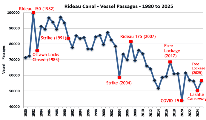
The chart above shows yearly vessel passages from 1980 to 2025. The big jump in 1982 was due to publicity surrounding the Rideau 150 celebrations. That same level of publicity wasn't achieved for Rideau 175 which saw a much more modest increase in boaters. The large declines appear to be mostly due to uncertainty about the operation of the canal including closures of all or part of the canal. In 1983, the Ottawa locks were closed for repairs. In 1991 and 2004 the union went on strike, closing the canal. Fee increases have a negative impact, but these tend to be much smaller than the effect of canal closures. The jump in 2017 was due to free lockage (tempered by bad weather). 2020 showed a significant decrease due to COVID-19 (locks opening late, no U.S. boaters, no U.S. cottagers, less transit boaters). In 2024, the main factor seems to be the closure of the Lasalle Causeway lift bridge (after Public Services and Procurement Canada badly damaged it, necessating its removal). When boaters hear that the Rideau Canal is closed or has issues, they tend to go somewhere else. 2025 saw a rebound due to free lockage from mid-June to the end of August (Canada Strong Pass) tempered by the continued restricted access at Kingston due to the very limited openings of the temporary bridge on the LaSalle Causeway.
The decline from 2009 to 2014 appears to be mostly due to lack of marketing to boaters by Parks Canada (Parks Canada changed their Rideau Canal marketing strategy in 2007/2008) and the lack of adaptability to new boating trends. The uncertainty over the season of the canal, radical fee proposals, and the reduction of hours in 2013, continued the precipitous decline to 2014. The restoration of 1 summer hour in 2014 (although still not to pre-2013 hours) plus good boating weather in both 2015 and 2016 helped provide a modest rebound. 2017 is an anomaly due to the free lockage (which resulted in a large increase in use by local boaters). 2017 did show that local boaters are very fee sensitive and represent a large lockage resource untapped by Parks Canada. 2018 and 2019 show the continued decline in private boaters - the numbers were sustained at slightly above 2016 levels by Le Boat's new Rideau Canal operation with 16 rental boats in 2018 and 20 in 2019. 2020 is an anomaly due to COVID-19. 2021, despite a lack of American boaters, saw a return to 2019 levels also due to COVID with more people taking to boating as a safe outdoor activity. The decline in 2022 was mostly with Quebec boaters, down 31% from 2021 - perhaps due to the jump in fuel prices. In 2024, there were declines across the board, including a continued decline of Quebec boaters as well as those from Ontario and the U.S. The increase in 2025 was mostly with Ontario boaters taking advantage of the free lockage.
Comments: send me email: Ken Watson
©1996- Ken W. Watson
|