| Number of locks: 2 (in flight) |
Total Lift: 4.9m ( 16 ft.) |
Lock Through Time: 30 min.* |
| Chart No: 1512 (Sheet 3) |
GPS:1 N 44o 53.590' W 76o 00.250' |
| Chart Sales: No |
Lockstation Tel: 613-283-2663 |
| Washrooms: Yes2 |
Drinking Water: Yes3 |
Day Use Docking: No |
| Overnight Mooring: Yes |
Docking4 Upstream: 61m/200' |
Docking4 Downstream: 61m/200' |
| Ice: No |
Power: No |
Boater Camping:5 Yes** |
| Boat Launch: No |
Picnic Tables: Yes |
BBQ Grills: Yes |
| Parking: Yes |
Public Telephone: No |
Self Guided Trail: No |
| Hwy Access: on Old Slys Road |
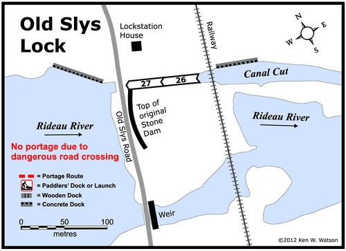
Lock Connects: Rideau Canal Cut to Rideau River |
| Civic Address: 9 Old Slys Road, Smiths Falls, Ontario |
| Special Notes: To ensure passage, boaters must arrive at least 1 hour prior to closing. Swing bridge with a clearance of 2.2m (7.1 ft). Swings on demand EXCEPT on Monday to Friday (exluding holidays) when it will not swing between the hours of 11:55 - 12:15h and 12:45 - 13:00h. Camping is available but not recommdended due to area nightime activities. |
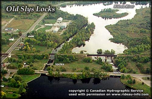
| Of Interest: Old Slys is a double lock, named after an early settler in the area, William Sly, who settled here in 1798. The CN rail line crosses the lockstation, a reminder of the importance Smiths Falls once serves as a railway hub. What appears to be a retaining wall below the road that crosses the locks, is actually the top of a 21 foot high dam (similar to the one near the Smiths Falls Combined Lock), placed in the main channel of the Rideau River. In the latter part of the 20th century, the area between the dam and the railroad was filled in. The Heritage House Museum is just a short distance south of the locks. |
| Notes: Closest gas is Rideau Ferry. |
|