Your location: Rideau Canal Home Page > Rideau Lockstations > Kingston Mills Locks 46-49
| KINGSTON MILLS Locks 46-49 |
|
|
| Number of locks: 4 (incl. 3 in flight) |
Total Lift: 13.7m ( 45 ft.) |
Lock Through Time: 1 hour* |
| Chart No: 1513 (Sheet 5) |
GPS:1 N 44° 17.540' W 76° 26.550' |
| Chart Sales: Yes |
Lockstation Tel: 613-507-3188 |
| Washrooms: Yes2 |
Drinking Water: Yes3 |
Day Use Docking: Yes |
| Overnight Mooring: Yes |
Docking4 Upstream: 88m/290' |
Docking4 Downstream: 93m/305' |
| Ice: No |
Power: No |
Boater Camping:5 Yes |
| Boat Launch: No |
Picnic Tables: Yes |
BBQ Grills: Yes |
| Parking: Yes |
Public Telephone: Yes |
Self Guided Trail: No |
Hwy Access: 1 km W of Hwy 15
on Kingston Mills Rd. |
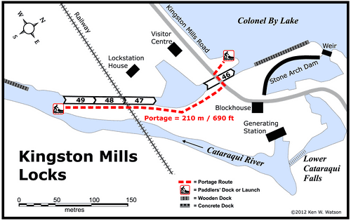
Locks Connect: Cataraqui River to Colonel By Lake |
| Civic Address: 563 Kingston Mills Road,
Kingston, Ontario |
| Special Notes: To ensure passage, boaters must arrive at least 2 hours prior to closing. Swing bridge with a clearance of 2.3m (7.5 ft). Bridge swings on demand.
|
Of Interest: This is the site of the first mill built on the Rideau, the King’s Mill, built here at Cataraqui Falls in 1784. The site today features a lovely set of three locks, a turning basin, a detached upper lock and the Robert Anglin Visitor’s Centre. The main CN rail line crosses over the lower locks on a bridge originally built for the Grand Trunk Railroad in 1853 (originally a wooden bridge, the current steel bridge dates to 1929). One of the four blockhouses on the Rideau is located here. It’s open during the summer months with the inside outfitted as the soldier’s barracks (closed in 2012). The falls, first used to power mills, still generate power today, a small hydro-electric station was built here in 1913. |
| Notes: Gas is available downstream at marinas in Kingston. No local services. |
|
* Time to actually go through the locks. Allow at least twice this time when trip planning. See Schedule Caveats.
1) GPS data should not be used for navigation. See the GPS page.
2) Washrooms are wheel chair accessible.
3) Unless indicated otherwise, water at the lockstation is potable.
4) Includes both blueline and greyline docking - see Lockstation Docking Page.
5) Allows tent camping for those arriving by water and also for cyclists and hikers.
|
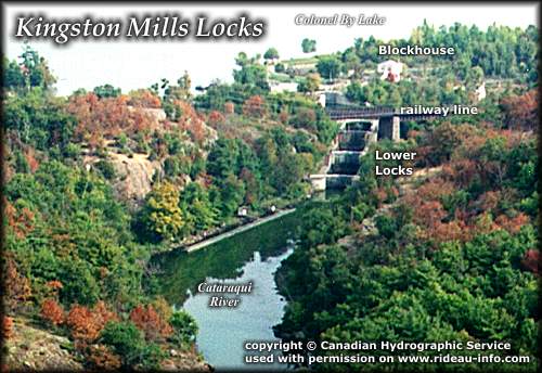 |
Kingston Mills Lockstation looking NorthThe first lockstation in the southern part of the Rideau, a flight of 3 locks, a turning basin and an upper lock greets the boating visitor. Located as it in close to Kingston, Highway 401 and Highway 15, Kingston Mills is a popular destination for the road visitor who wish to see a working lockstation.
photo copyright © Canadian Hydrographic Service - used with permission |
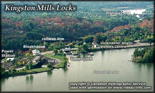 |
Kingston Mills Lockstation looking SouthwestColonel By Lake, part of the Cataraqui River was formed by the building of the locks and dam at Kingston Mills. The Blockhouse, one of only four built along the Rideau, has a commanding view of both the north and south approaches to the lock.
photo copyright © Canadian Hydrographic Service - used with permission |
Comments: send me email: Ken Watson
©1996- Ken W. Watson
|