Smiths Falls
| |  |
| |
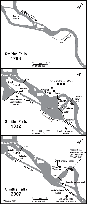
Smiths Falls schematic by Ken W. Watson, 2007
|
As French continued his journey south in 1783, he paddled through another area that has since seen a large landscape change. At the north end of present day Smiths Falls he encountered Sly’s Rapids. These were 2,160 feet (658 m) in length with a drop of 15 feet (4.6 m). Continuing north he encountered Smith’s Falls, stating “we met with Eight Falls in the Distance of a mile, from 4 to 10 Feet each, and the River Divided by several Rocks and Islands forming very convenient places for Mills.” The falls and rapids in this location extended over a distance of 3,600 feet (1,100 m) with a combined drop of about 34 feet (10.4 m). Later on, one of the Royal Engineers would describe Smiths Falls, while trying to figure out a navigation solution, as “a bit of a puzzler.”
Today, much of the original landscape and even of the canal’s modification to this landscape are partially buried. At Old Slys, what looks like a retaining wall below the road on the south side of the locks is in fact the top of the 23 foot (7 m) high canal dam placed across the original channel of the Rideau River. Backfilling the area between the dam and the railway bridge took place in the 1960s.
The changes are even more dramatic in Smiths Falls. Someone standing on the pavement of the parking lot below the water tower is in fact standing over a backfilled section of the original Rideau River. The retaining wall for the parking lot is the top 4 feet (1.2 m) of the original 23 foot (7 m) high canal dam that was used to block the Rideau River in this location. That configuration is difficult to visualize today. This area was also backfilled in the 1960s.
The schematic diagram shows that in the pre-canal era the Rideau River flowed around Rocky Island, and in a set of rapids and waterfalls, through a series of small islands to an looped (oxbow) bend in the river. A flood channel, later called “Hornet’s Snie” (since one of the surveyors got stung by a hornet in that gully), existed just south of the bend.
When Colonel By arrived on the scene in late 1826, Abel Ward was operating a sawmill in this spot. The mill dam was located at the head of the oxbow, just a little bit upstream from where the canal dam was later to be constructed. The sawmill was on the west bank of the river, just a little bit downstream from where the canal dam was constructed. The original dam and sawmill had been built by Thomas Smyth in 1823, but he lost the property due to a mortgage default in 1825.
Colonel By originally proposed to make the dam an overflow dam and place the locks in Hornet’s Snie. However, like most of the lockstations, By had to make changes due to problems such as survey errors, leaky bedrock and excessive water during spring runoff. Those particular problems necessitated a change at Smiths Falls. To control spring runoff, By opted not to make the main canal dam an overflow dam, but instead raise the height of that dam and put a water control weir into Hornet’s Snie.
The original three locks planned for Hornet’s Snie were moved to a canal cut excavated in the south bank of the river. Due to leaky bedrock and more detailed information on local topography, the lift of those locks was lowered, and the remaining lift given to a detached lock, placed on the south side of Rocky Island (now Lock Island). A second weir was constructed on the north side of Rocky Island to provide a navigation depth of water of water over the upper sill of the detached lock.
Over the years, further changes have taken place, most notably the burial of the main canal dam in the 1960s, the construction of a new combined lock in the 1970s to accommodate a new low level fixed bridge, and the construction of new retaining walls, reducing the size of the basin.
|