Lt. Joshua Jebb’s 1816 Survey
| |  |
| |
Stegman's Rapids
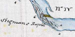
This detail section of Jebb's 1816 maps shows Stegmans Rapids in the Rideau River, still visible today adjacent to the campus of Carleton University in Ottawa. The numbers to the left of the river are Jebb's current measurements (in miles per hour) and the numbers in the river are his depth measurements (in feet). The brown rectangle in the middle of the rapids is one of his proposed "wings" - a partial dam that would double the depth of water over the rapids, allowing shallow drafting boats to be towed up or winched down. Section from “Plan of the Water Communication from Kingston to the Grand River” by Lt. J. Jebb, July 8, 1816, Libraries and Archives Canada, NMC 21941 1/3.
|
Joshua Jebb was a newly minted Royal Engineer in 1816, having graduated from Royal Military Academy at Woolwich, with a commission as a 2nd Lieutenant, in 1812. In 1816, the young Lieutenant was in his early 20s and full of ideas about how to make the Rideau navigable. Jebb was looking for a route that could be made navigable for vessels that drafted up to three feet (0.9 m) of water and were up to twelve feet (3.7 m) in width. To this end he proposed a series of locks, rail ways and wings (partial dams). He also created the most detailed map of the Rideau Route to that time, a large map showing the various rapids and lakes in reasonably accurate (for the period) detail.
Jebb is perhaps best known as the surveyor who recommended the “Irish Creek Route” over the “Rideau Lakes Route.” Jebb proposed to take the canal up Irish Creek (located a few km south of Merrickville), over the watershed divide (near Plum Hollow), down through Lower Beverley Lake and then up the White Fish River (Morton Creek) to the Cranberry Flood Plain where it would connect with the Cataraqui River. This was a shorter route than taking the canal by way of the Rideau lakes.
The main problem with Jebb’s proposal was that while the top of the Rideau lakes route was water (a lake), the top of the Irish Creek route was dry. Jebb was well aware of this deficiency and proposed to put in a 5 mile (8 km) long railway: “A Road cut from Koyles to Parishes in a direct line, would not exceed 5 miles and for this distance I would construct a rail way using a particular description of low cart for transporting stores to where the water communications again commence.” What Jebb was proposing is that a boat’s cargo would be offloaded onto these railway carts and then re-loaded onto boats at the other end of the railway.
While Jebb’s canal proposal was never followed (Samuel Clowes discounted the Irish Creek route and Colonel By never considered it), he did leave a great Rideau legacy in the map he created as a result of his survey, one of the best views of the pre-canal Rideau.
 |
Jebb’s 1816 Rideau Map – Central Section
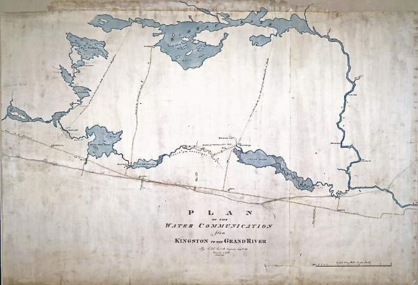
This central portion of Jebb’s Rideau map shows his preferred “Irish Creek Route” (lower rivers and lakes on map) as a more direct line with less distance than the Rideau Lakes Route (upper lakes). “Plan of the Water Communication from Kingston to the Grand River” by Lt. J. Jebb, July 8, 1816, Libraries and Archives Canada, NMC 21941 2/3.
|
|