Your location: Rideau Canal Home Page > History > The Rideau Route > The Coming of the Mills

The Rideau Starts to Change:
The Coming of the Mills
In 1784 the King’s Mill at Cataraqui Falls was completed. A dam built for this sawmill flooded the Cataraqui River in the region now occupied by Colonel By Lake. This was the first known significant man-made alteration of the Rideau Route. Surveys subsequent to 1784 were to map a human-altered landscape. These alterations were being made by entrepreneurs who were discovering rapids along the Rideau system – building dams at those locations to supply water power to mills.
On the Rideau River, in about 1790, it was Roger Stevens who erected the first mill and dam at present day Merrickville and started the man made alterations to that section of the Rideau Route.
The most significant pre-canal alteration of the Rideau was made in about 1803 by Lemuel and Carey Haskins. The Haskins brothers were looking for a source of water power and ended up at White Fish Falls, the location of present day Morton. They constructed a dam and sawmill at this location. However, no matter how high the dam was built it could only raise about a seven foot (2.1 m) head of water. So, they went looking for where his water was escaping. They found that their dam had caused the backed-up waters of the White Fish River to start to flow over the Cranberry Flood Plain, down to the Cataraqui River (see maps below). Following their errant water, they ended up at the Round Tail, a rocky constriction through which the Cataraqui River, coming from Loughborough and Dog lakes, flowed.
To impound the escaping water, a dam was built at the Round Tail. This, together with his dam at White Fish Falls, raised the water about six feet (1.8 m) over the Cranberry Flood Plain, creating an extremely large mill pond. Haskins’ construction of these two dams also achieved something else, navigation by flooding. The next surveyor to note these dams was Joshua Jebb in 1816. Jebb arrived at the Round Tail by paddling his canoe over the Cranberry Flood Plain, now made navigable by Haskins’ mill dams.
Lemuel and Carey Haskins can go down in history for not only being the first to connect the former western Gananoque watershed to the Cataraqui watershed, but by also being the first to provide a working example of a slackwater navigation system on the Rideau Route.
|
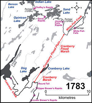 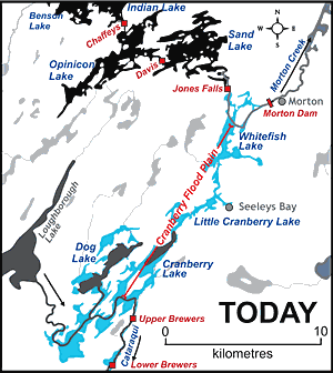 |
Navigation by Slackwater Flooding
In the pre-settlement era, the area between Jones Falls and Upper Brewers Rapids was a forested flood plain, impassable by canoe. These maps show what that area looked like in 1783 compared to how it looks today. The building of mill dams at White Fish Falls (Morton) and the Round Tail had flooded the plain to a depth of about 6 feet by 1816, allowing canoes to pass through the drowned forests. This area was known as the Drowned Land in the pre-canal era. Canal dams located at Morton and Upper Brewers flooded the plain to a depth of about 17 feet in 1832, creating the waterway, including several new lakes, which we see today. Schematic maps by Ken W. Watson, 2007.
|
Comments: send me email: Ken Watson
©1996- Ken W. Watson
|