Merrickville
| |  |
| |
Merrickville schematic by Ken W. Watson, 2007
|
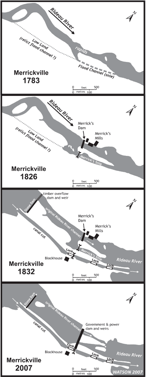
Merrickville is another example of a landscape change. It was the water power potential of the “Great Falls” at Merrickville that attracted Roger Stevens to build a mill at this location in about 1790. He was followed by William Merrick who built more extensive milling facilities which led to a well established settlement in this location by the time of canal construction. [note: Merrick spelled his name as “Mirick,” but the spelling “Merrick” will be used in this paper for consistency].
In the pre-settlement era the rapids in this location extended over a distance of 3,900 feet (1,190 m), with a cumulative drop of 26 to 28 feet (7.9 to 8.5 m). In describing this section French stated: “meeting with a considerable Fall and a Carrying Place of 400 yards.” The “Carrying Place” was a portage, the second such while heading south on the Rideau Route (the first being the portage around Rideau Falls). In his 1827 survey, MacTaggart referred to “Merrick’s Falls,” stating that “we have to contend with a fall of twenty-seven feet ten inches; that is; from Macrea’s still-water to the still-water below Merrick’s Falls.” The waterfall portion of the rapids was reported to have a drop of 14 feet (4.3 m).
To the south of the rapids was a gully, which in 1827 was referred to as a “snie” – a dry flood channel running parallel to the river. In many instances on the Rideau, Colonel By took advantage of these snies to place his locks. They formed a convenient location to be able to build his locks “in the dry” and then flood a navigation depth of water into the snie with the use of a dam placed in the original river channel.
At Merrickville, Colonel By’s concern was to keep William Merrick’s mills intact. Merrick was already using the snie as a waste water channel, excess water diverted by his mill dam was running though the snie. Colonel By realized that if he used the snie for his locks, he risked damaging Merrick’s mills, since the full flow from the Rideau River would be forced over Merrick’s dam.
By’s solution was to dig a bypass channel. The upper part of the bypass channel took advantage of pre-existing low land, a relict channel of the river. A canal dam consisting of a fixed stone dam and a wooden weir was constructed across the Rideau River near the head of the canal channel. Three detached locks were constructed in the channel (to take best advantage of the topography). In the end, the configuration was a canal dam diverting water into the canal channel, with the main flow of the river through the canal weir to Merrick’s dam and waste water channel (in the original snie). This provided navigation while leaving Merrick’s operation untouched.
In 1912 the configuration was changed, the timber canal weir which had some problems was removed and a new weir was built in concrete at the head of the Merrick’s Snie. This is the landscape that we see today.
|