The Rideau Route in 1783 / Hogsback
Although most of the Rideau was drowned with the building of the canal, one section, that of the Rideau River in Ottawa, still contains elements of what the river looked like the pre-canal era. When the canal was built, this section of the Rideau River, from Hogs Back to Rideau Falls, was bypassed with a canal cut.
Rideau Falls looks today much as it would have looked to Samuel de Champlain, who is attributed with coining the name “Rideau” – which is French for “curtain” – the appearance of the falls to Champlain. A dam at the top of the falls has flooded the lower set of rapids (the Cascade Rapids) – but proceeding upstream one can still see Billing’s and Stegman’s rapids, much as they would have appeared in the pre-canal era. Stegman’s Rapids, located beside Carleton University, are a good example of a pre-canal set of rapids. The rapids are formed by the Gloucester Fault, which has upturned the limestone rocks in that area, creating an erosion barrier and hence the rapids. There was no portage at either Billing’s or Stegman’s rapids, natives and early surveyors simply hauled or lined their canoes up and down these rapids.
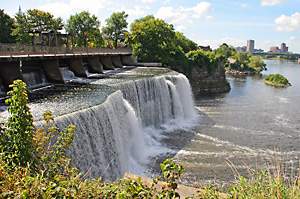 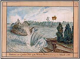 |
Eastern Rideau Falls
Left: eastern Rideau Falls looking west, 2006. Right: eastern Rideau Falls looking east, 1830. "Eastern and Greater Fall of the Rideau River, sketched from the Island in 1830” by Thomas Burrowes, Archives of Ontario, Image I0002199. Photo by Ken W. Watson, 2006.
|
Hogs Back “Falls”
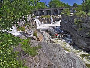 | |
Hogs Back: Prince of Wales Falls
It's hard to image canoes shooting these falls. That's because they didn't - these falls did not exist in the pre-canal era. Photo by Ken W. Watson, 2005.
| |
The dramatic landscape change brought about by the building of the Rideau Canal is perhaps most evident at the Hogs Back lockstation and dam, and its present day appearance has led to several misconceptions about what this area looked like in the pre-canal era.
The Parks Canada signboard at Hogs Back states “Two hundred years ago, here, in the midst of a dense forbidding forest, a spectacular falls with a set of 3 treacherous rapids roared.”
In Robert Legget’s book Rideau Waterway he tells a story of the Billings family shooting the falls in 1814. The story goes that while Braddish Billings and family were sitting in their canoe above the falls talking to Philemon Wright (who was standing on shore) – the canoe drifted and “it was caught in the swift water and carried over the falls before the eyes of Wright’s horrified party.” Rushing to the bottom of the falls, Wright was surprised to find the Billings family safe and sound. Legget continues “This is believed to be the only occasion on which a canoe shot Hog’s Back Falls; even the most experienced Indian travelers would never attempt the feat.” Legget likely got this story as a local anecdotal tale and looking at today’s falls the story is easy to believe. Since printed it has been repeated many times. However there is slight problem with both this story and the Parks Canada signboard; in the pre-canal era there were no falls at Hogs Back.
| |  |
| |
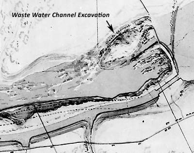
Hogs Back Weir, Dam and Locks in 1830
This canal map shows the excavation for a waste water weir, the location of today’s Prince of Wales Falls. In the pre-canal era, the rapids in this location dropped 6 feet over 2000 feet, there were no falls. The canal dam raised the water 41 feet in this location. It is this raised level of water, which now flows through the weir and the excavated channel, and down into the original river bed, that creates the falls that we see today. “Survey of Hogs Back Rideau Canal” by John By, January 22, 1831, National Archives of Canada, NMC 21975.
|
Hogs Back is the spot where the Rideau Canal leaves the Rideau River and proceeds through a canal cut (parts using pre-existing ravines – it’s not all “man-made”) to the Ottawa River. The dam at Hogs Back was to do two things – it was to flood the Rideau River all the way to Black Rapids, putting a navigation depth of water over the lower sill of the lock at that location and it was also to put water over the upper sill of the locks at Hogs Back, the entrance to the canal cut to the Ottawa locks. This called for a big dam, in the end (with many difficulties) it raised the Rideau River at this spot by 41 feet (12.5 m).
The dam is built on the head of the original rapids (not falls) which were known as Three Rock Rapids. These rapids dropped about 6 feet over a distance of 2000 feet. Natives, surveyors and voyageurs didn’t portage these rapids. So where did the falls that we see today come from?
Today’s Prince of Wales Falls are the 41 feet (12.5 m) of dam raised water rushing through a man-made waste water channel, excavated in the east bank of the river during the building of the Rideau Canal. Canal construction era maps show this channel as a “waste channel” and as“excavated for bye [bywash] channel” With this in mind, a visitor to Hogs Back can now clearly see that these are man-made falls. While the dam is hiding the top portion of the original rapids, the lower portion of the rapids is still visible. There was a later portage around these rapids, developed for those less adventuresome than the natives, surveyors and voyageurs, such as the Billings family, but they were bypassing a set of rapids, not “a spectacular falls.” The lower portion of these rapids still exists and a visitor looking at this section of rapids will get a sense of what early travelers on the Rideau Route would have seen.
|