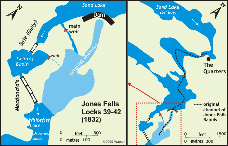
Jones Falls Locks 39-42
| location map | lockstation information |
"the exceeding unhealthiness of the place from which cause all engaged in it suffered much from lake fever and fever & ague, and it has also retarded the work for about three months each year." - from a letter written by Jones Falls' contractor John Redpath in December 1831 noting the problems with seasonal malaria.
The Setting
Prior to the construction of the canal, the water from Sand Lake drained through a series of rapids and shallows, over a distance of 1,833 yards (1,676 metres). These rapids were originally known as Long Falls, plunging through a windy ravine characterized by high rocky banks. There were no significant waterfalls. The total drop of water over the 1 mile (1.6 km) distance was 59 feet (18.0 m) to the level of water in the "Drowned Lands," lands flooded below Jones Falls by the pre-canal mill dams at Morton and the Round Tail (foot of Cranberry Lake). A 1,500 yard (1370 m) portage bypassed these rapids on the east side, from the foot of Eel Bay of Sand Lake to the foot of the rapids, located just upstream of the present day bridge near the Hotel Kenney. Near the lower end of the ravine, just to the southwest the present day dam, was Macdonald's Snie, (or Macdonald's Gully) a dry flood channel some 677 yards (619 m) in length.
The area at the time was a wilderness. The rapids were named after Charles Jones of Brockville, the absentee landlord who had been granted land at the head of the rapids (foot of Eel Bay), but had never occupied it. The main portion of the rapids flowed over land granted to Nancy Knapp, another absentee landlord. The base of the rapids was on land held as Crown Reserve.
The Plan
Samuel Clowes' 1824 plan had six detached locks, spaced about equally along the one mile (1.6 km) length of the outlet of Sand Lake. It was later noted by MacTaggart that this configuration would place the locks in the way of spring flood. MacTaggart also noted that the ravine was crooked, and it would be difficult to get the locks oriented to allow room for the proper approach of boats.
Another proposal was to place two dams, each with a 30 foot (9.1 m) lift, at two narrow sections in the ravine. It was noted that with this configuration it would be difficult to fit in the locks.
A third proposal was to put a 20 foot (6.1 m) dam at the foot of the first rapid (outlet of Eel Bay) and to place a canal cut on the east side of the river, bypassing the ravine entirely. It was noted that this would require an artificial channel about 2 miles (3.2 km) long, requiring much rock excavation.
The fourth proposal, and the one adopted with some modifications, was to place a dam at the lower end of the ravine, about 750 feet (229 m) from the lower still water (now Whitefish Lake), and about 14 feet (4.3 m) in elevation above that still water. The dam would be an overflow dam, 48 feet (14.6 m) high. This would give a combined lift of 62 feet (18.9 m), flood the rapids, and put an additional 2 feet (0.6 m) of water into the planned lock at Davis' Mills. Two sets of three locks in flight, each lock with a lift of 10 feet, 2 inches (3.1 m), would be placed in Macdonald's Snie separated by a 300 foot (91 m) long by 130 foot (39.6 m) wide turning basin in the middle. It was noted that the upper entrance to the snie was 130 feet (39.6 m) wide, sufficient for navigation. It was also noted that by placing the locks in the snie, they could be built "in the dry," facilitating their construction. The dam would be 216 feet (65.8 m) long at the top, but would narrow down towards the base, making the average length only 100 feet (30 m). It would put a 33 foot 6 inch (10.2 m) head of water above the highest part of MacDonald's Snie. In the end, the dam was made larger and non-overflow (see below).
Building the Locks
Mr. Reuben Sherwood was awarded the contract for the initial excavation of the lock and dam site. The masonry contract for building the locks and dams was given to the partnership of John Redpath and Thomas McKay. It was John Redpath who did the work on this site.
 Early work proceeded well, although By was hampered by his own request for larger locks. Initial work had been done based on the smaller (108 foot (33 m) long) locks. Given the topography of MacDonald's Gully, it would make quite a difference if a larger size lock was to be decided upon. By lobbied in the spring of 1828 to be allowed to start construction of the larger lock size (150 feet (46 m)) that he had proposed. General Durnford wrote back to By on April 24, 1828 that "I feel it my duty (though reluctantly) after the Orders received both from the Ordnance and Treasury Boards, and so lately communicated to you, to give it as my decided opinion that it is not advisable to commence any description of Lock at present; but to confine the Contractors to the mere preparation of Stone until the result of Lieut. Pooley's mission to England with your Estimates and Plans shall have been received which it is reasonable to expect will be very Shortly." Early work proceeded well, although By was hampered by his own request for larger locks. Initial work had been done based on the smaller (108 foot (33 m) long) locks. Given the topography of MacDonald's Gully, it would make quite a difference if a larger size lock was to be decided upon. By lobbied in the spring of 1828 to be allowed to start construction of the larger lock size (150 feet (46 m)) that he had proposed. General Durnford wrote back to By on April 24, 1828 that "I feel it my duty (though reluctantly) after the Orders received both from the Ordnance and Treasury Boards, and so lately communicated to you, to give it as my decided opinion that it is not advisable to commence any description of Lock at present; but to confine the Contractors to the mere preparation of Stone until the result of Lieut. Pooley's mission to England with your Estimates and Plans shall have been received which it is reasonable to expect will be very Shortly."
At the end of June 1828, the Kempt Commission gave its approval to locks 134 feet (41 m) long by 33 feet (10 m) wide. This meant that the original plan of six locks, each with a 10 foot lift (3.0 m), would have to be changed. By's modification of the original plan was to place three locks in flight at the bottom of MacDonalds' Snie with a single detached lock at the top, separated by a turning basin. Each lock would have a lift of 15 feet (4.6 m), considered dangerously high in those days. It was noted that construction of the locks would have to be of the highest quality and reinforced lock gates were designed for use at these locks.
In By's 1830 report he stated: "Having cleared the ground and carefully examined the same prior to laying out the works it was ascertained that the Snie in question was not at all adapted for placing the Locks required to provide for a Steam Boat Navigation either as regarded the position, or for the equal division of the rise to be surmounted, as Shewn upon the plan submitted to and approved of by the Committee, independent of a very considerable increase in Rock Excavation, which would be incurred by following the same, the removal of which would be attended with a very serious expense ….
…. It was not contemplated that any general alteration from the mode of forming the Canal as described upon the Plan of the Locks, on the small scale beyond what would occur in consequence of the increase in the dimensions of the Works, was likely to take place, nor has such been the case, but in the present instance, as the Plan in question did not afford the necessary facilities for a Steam Boat Navigation, and could not at any rate have been carried into effect, without incurring a very heavy and unnecessary expenditure for the reasons above stated, a deviation from the same was rendered indispensably necessary, and I consequently considered myself fully Authorized in making such alterations as the nature of the case appeared to call for taking care at the same time that they did not tend to lessen the permanent security of the Works or incur any unnecessary or avoidable expense and have therefore placed three Locks of 15 feet lift each at the lower end of the Snie situated so as to afford the easiest and most direct Entrance to them from the River, which it was possible to attain and a fourth detached of 15 feet Lift to suit the Section of the Ground, the Space between the Combined and detached Locks being formed into a Basin this appearing to me the most judicious mode that could be adopted to meet the difficulties above stated."
By, learning from his experiences at other lockstations, changed the plans for the dam from being an overflow dam to being a dam and waste weir combination. In making the changes By noted that "The System of allowing the Water to flow over the Dam having been abandoned as precarious and dangerous to the Works …" To prevent overflow he raised the planned height of the dam by 7 feet (2.1 m). By also noted that in order to provide a good foundation for the dam, which would have to hold back upwards of 60 feet (18.3 m) of water, it was necessary to dig down 8 feet (2.4 m) into the bed of the river in order to find solid rock on which a good foundation could be laid.
 |
Abandoned cut stone
in Halladay's Quarry
photo by: Ken Watson, 1999
Blocks of stone were rough cut and then transported to the locks where they would be finished. |
Costs increased when it was determined that no stone suitable for the key work (cut stone) of the dam could be quarried locally: "it was ascertained that the Rock [from local quarries] turned out in such irregular Blocks, that they could not be rendered available without incurring a much greater Expense than [using the quarry in Elgin]." So the sandstone blocks for the dam and locks were hauled to the site from the quarry on Henry Halladay's property near Elgin, about 6 miles (10 km) away. The blocks were rough cut at the quarry by a crew of about 20 masons who were housed at the site. The rough cut blocks were hauled by local farmers, using ox drawn sledges, along a road built to Jones Falls in 1827. The finishing work on the stones was done on site. Finishing work in winter required that the stones be thawed prior to being chiselled for fear of fracturing the frozen rock.
Work at the site was hampered, as it was in most of the southern Rideau, by malaria. It first hit particularly hard in the summer of 1828. In a letter from Captain Savage to John By, 6 September 1828, he wrote, "… The works at Jones' Falls are almost at a Stop with the exception of a few men employed at the Quarry, the Contractor, asst Overseer, two Clerks and nearly all the workmen are laid up with the fever and ague. ..." Savage also noted that 121 men had left Jones Falls prior to August 1 "from fear of the sickness."
During the height of construction, as many as 260 workers were on site, including up to 40 stone masons, about half working directly on the site and half who working at Halladay’s Quarry. In subsequent years, about two-thirds of this workforce would become incapacitated for a month or longer due to malaria. The workforce was divided about equally between "Scotsmen" and "Canadians," the latter being mostly French Canadians. Most of the workers stayed in a construction camp locally known as Esthertown, after Colonel By's wife, Esther By. The officers and staff of the Royal Engineers stayed in a camp at the head of the portage that bypassed the rapids. This area was known as "The Quarters" (officer’s quarters).
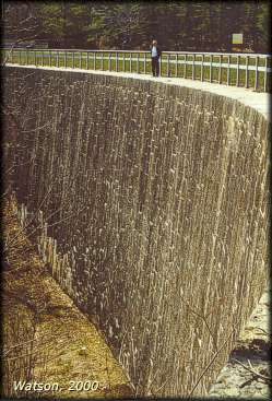 |
Jones Falls Dam
photo by: Ken Watson, 2000
The beautiful stonework of the dam stands as first built 170 years ago. |
The dam was the major construction project at Jones Falls. With a planned height of almost 60 feet (18.3 m), it was to be the highest dam built in North America. It was constructed like other Rideau stone keywork dams. The keywork (dressed stones), were the backing of the dam. This stonework was about 27 feet (8.2 m) thick at the base of the dam, tapering to 12 feet (3.7 m) at the top. The dam is built in the shape of an arch which throws the weight of the water it is holding back into the bedrock on both sides of the dam. It was built using large, 6 foot (1.8 m) long, 3 feet (0.9 m) wide by 2 feet (0.6 m) thick sandstone blocks, placed on end, with about a 1:10 incline (a 1 foot setback for every 10 feet of elevation). Slighly smaller blocks were used as facing stones.
The dam was built without the clay puddle that would normally have been placed behing the stone keywork. Clay of suitable quality and quantity ran out early in construction and grouted broken stone (small stone set with hydraulic cement) was substituted. This use of grouted stone may have been similar to that used at places like Clowes where clay was not available to make the clay puddle. The grouted broken stone was placed with about a 5 foot (1.5 m) thickness behind the keywork. On top of that was a sloping apron made of "rubbish" material - clay, gravel and earth. This sloping front was inclined at a 2.5:1 ratio, in other words, with a 60 foot (18.3 m) high dam, the bottom of the slope would extend out 150 feet (46 m) from the base of the dam.
In order to keep the water in control during construction, a sluice was kept opened in the dam. Two sluices were used. The first was near the base of the dam on its east side. A second sluice was put in on the west side of the dam, about 20 feet (6 m) above the base. To make the switch from the lower to upper sluice, the outlet of Sand Lake was blocked off with a coffer dam. This coffer dam was located slightly downstream from The Quarters, allowing continued water access to that location with the coffer dam in place. With the water flow stopped, the men worked furiously to put grouted broken stone into the lower sluice, while at the same time completing the stonework on the face of the dam (the keystones were pressed up against the clay and grout). Once the lower sluiceway was filled to the level of the second sluice, the water from Sand Lake was released. This second sluiceway was still below the level of MacDonald's Snie, keeping it dry for the lock construction. The second sluiceway was not sealed off until the waste weir and the upper lock were completed.
The dam stands today, with a total height, from the base of its foundation to the top of the earthen berm, of 60 feet (18.3 m). The stonework is 57.1 feet (17.4 m) high, made up of 50.9 feet (15.5 m) above the bed of the river with a foundation sunk 6.2 feet (1.9 m) into bedrock. The earthen berm at the head of the apron is about 3 feet (0.9 m) higher than the top of the stonework, making the dam 60 feet (18.3 m) high. The top course of stones is 350 feet (106.7 m) long (following the trace of the arch). The dam, just above the riverbed, is 100 feet (30.5 m) long.
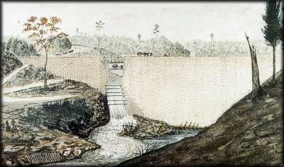 |
Dam at Jones Falls; when nearly completed, showing the last temporary passage provided for surplus water, 1831
Thomas Burrowes, watercolour, Archives of Ontario
This dam blocked off the original channel of the White Fish River at Jones Falls. Visible at the left rear of the painting is a road on the far side (west) of the channel leading to pits where clay and gravel were excavated to form the front apron of the dam. Small carts were used to transport this material, across a bridge, to the dam. Part of this bridge can be seen behind the gap of the upper sluice. |
A waste weir was constructed in the bedrock to the west of the dam (between the dam and the upper lock). It was blasted to a depth that would place the bottom of it 15 feet (4.6 m) below the planned final level of water. Once the upper lock was completed, the entrance to the sluiceway in the dam was sealed off with stop logs, then it was filled in the same way as the first. When the water rose up above this second sluiceway, it flowed out through the new permanent waste weir. With the water now flowing through the permanent waste weir, the dam was completed to its final height. The falls we see today (Redpath Falls) is water coming through this man made waste weir.
The locks were built on inverted masonry arches. Lt. Frome noted; "They have altogether a most beautiful appearance, and seem hitherto to have answered perfectly, notwithstanding their dangerously high lifts." The lower three locks were built together "in flight." The lowest lock had a lift of 13 feet (4 m), the other two, 15 feet (4.6 m) each. A turning basin was placed between the lower 3 locks and the upper detached lock. A small weir was put into the turning basin to control any excess water. The upper lock was built with a lift of 15 feet 2 inches (4.6 m) and a 3 foot (0.9 m) guard (height above normal water level). The sills were made of oak, bolted and strapped to the bedrock.
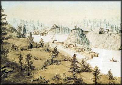 |
Jones Falls; post-1843
William Clegg, watercolour, Public Archives of Canada
Although the perspective is a not quite true in this painting, it does show the flight of three locks, the turning basin and the upper lock. The defensible lockmaster’s house sits above the upper lock as it does today. The blacksmith’s shop and a storage shed are located to the left. To the right of the basin is the wooden guardhouse. On the right are some of the lockstation staff housing. |
Through the Years
In 1838 a wooden guardhouse with dimensions 20.5 feet by 22.5 feet (6.2 x 6.5 m), was built here by Lockmaster Sweeney and his canalmen in response to the rebellion crisis of 1837. It was located about 100 feet (30 m) up the hill on a rocky knoll, kitty-corner to Lock 40 (the top lock of the lower flight of three) and the turning basin. It was sometimes referred to as a blockhouse in early documents, but it was essentially the same as the later stone defensible lockmaster's houses, except it was built of squared cedar timber. It served as accommodations for militia stationed at Jones Falls until about 1842 and then as a storage building for military supplies until 1855. From about 1856 to near the turn of the century, it was used as a canalman's house. By 1900 it had been abandoned. The wooden guardhouse was allowed to deteriorate and it was dismantled in 1939.
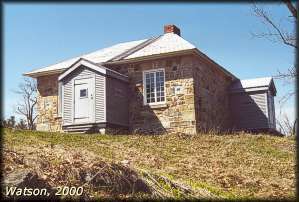 |
Lockmaster's House at Jones Falls
photo by: Ken Watson, 2000
Restored to its 1840s glory, the house has been refurbished on the inside to provide an interesting interpretive display. |
In 1841, a stone defensible lockmaster's house was constructed at the top of the hill above the dam and upper lock. It is thought that the stone used for the construction, a rough cut pinkish stone, was quarried locally. It is likely that when originally built, the tin shingles were painted red. In 1913-14 a cement floor was laid in the basement. A kitchen wing was built onto the building in 1886. In the early 1940s, a two storey framed addition, which included a new kitchen, was added to the south side of the building. The last lockmaster to stay in the house, Alfred Sly, left in 1962. In 1968, it was decided that the building should be returned to its 1840s state and the two-storey addition was torn down. However no other work was done to restore the building until 1979-80, when renovations were completed and the building turned into a "living" museum.
In 1843, a 28 foot x 22 foot (8.7 m x 8.5 m) stone blacksmith's shop was built on the west side of the turning basin. During the construction of the locks a simple log blacksmith's shop had been used. However, canal officials argued that given the isolation of the area, and the height of the lock gates, a permanent, on-site blacksmith's shop was required. It doesn't appear that a full time blacksmith was ever at Jones Falls. Rather the blacksmith's shop was used by canal smiths on an as-needed basis, and after about 1855, local smiths were brought in to use the shop to do repair work. In 1978-79, Parks Canada restored the blacksmith's shop and today you'll often find the Parks Canada blacksmith working away using the same tools of the trade as used in the 1800s.
The locks required normal maintenance for the first few years. In 1866, a 70 foot (21.3 m) long section of the wall in the turning basin, near the head of the combined locks, collapsed and had to be repaired. In 1905-1906 the weir in the turning basin was reconstructed in masonry. The locks were extensive repaired in 2018-2021. The original weir had just been a timber sluice in an embankment of clay and gravel. The main weir was rebuilt in 2010. The original wooden bridge across the weir channel was repaired/replaced several times and re-done in concrete in 1932. It was replaced in 2016.
The original Long Bridge, extending from the east bank of the channel (near where the Hotel Kenney is today) to the foot of the locks was built in about 1830. It was likely flooded with the rise of water after the dam at Upper Brewers was completed in early 1832. In 1883, a new Long Bridge was built in the same location and a timber swing bridge was installed across the second lock (Lock 41). This timber swing bridge became superfluous when a new fixed bridge was built, upstream of the Jones Falls Lockstation, in the 1970s. The timber bridge was an unequal arm, center bearing timber swing bridge (sometimes erroneously called a Kingpost Truss swing bridge), one of five of this type still surviving on the Rideau Canal at that time. The bridge was supposed to have been preserved in-situ, but was allowed to deteriorate and in 1988 it was cut-up and removed. Only the abutments for this bridge can be seen today. The original 1883 Long Bridge was replaced with a new wooden bridge in 2019.
Sometime after 1930, a wood frame storehouse was built a little ways downhill of the old wooden guardhouse. Today it serves as a visitor's centre.
The power plant below the dam was built in 1947. Timber sluiceways were connected to a weir cut through the west end of the dam. The power plant is operated today by Portage Power.
In 1877, Thomas Kenney built a combined inn and store on the Jones Falls Road. It burned down in 1888 and Kenney relocated to the waterfront near the lock and built the current Hotel Kenney. In 1906 an annex was built and a third storey was added to the original 2-storey main building.

The Great Dam at Jones Falls - shown in an 1841 painting by Thomas Burrowes (Archives of Ontario) and in a photograph, taken by the author in April 2000.
The Lockmasters to 2000
The first lockmaster was Peter Sweeney who served here until his retirement in 1871 (his 1839 to 1850 diary has been published as a book by Friends of the Rideau). He was replaced by Henry Layng who didn't get along with any of the locals and was eventually fired in 1874. His replacement was Robert Bolton, lockmaster at Narrows Lock. Bolton retired in 1897 and was replaced by Alfred Forster, the lockmaster at Davis Lock. Forster was retired in 1901 and was succeeded by Samuel G. Stuart of Newboro who retired in 1924. James Mooney was appointed lockmaster in 1924 and was replaced in 1933 by Alfred Sly. Sly retired in 1962. He was followed by Ray Cheetam from 1962 to 1971; unknown in 1972; Allan Blair from 1973 to 19
|