Upper and Lower Beveridges
Locks 33-34
| location map | Lower Beveridges lock info | Upper Beveridges lock info |
The Setting
The settlement of Perth, established in 1816, was located on the Tay River, about 8 miles (13 km) upstream from Rideau Lake. The Tay River over that distance descended about 30 feet (9.1 m) to Rideau Lake. About two miles (3.2 km) upstream of Rideau Lake on the Tay River was Fishing Falls. These were about one and half miles in length (2,400 m), with a vertical descent of 19 feet (5.8 m). Less than a mile above Fishing Falls were M’Vittie’s Rapids that extended almost a mile (1,600 m) in length, with a drop of 7 feet (2.1 m) over that distance, to the foot of M’Vittie’s Still Water. At the head of M’Vittie’s Still Water, located just above the confluence with Jebb Creek, were the Upper Rapids, a few hundred feet in length (~100 m) with a drop of about 1.5 feet (0.4 m). The Tay, downstream of Perth and outside of the rapids, averaged about 3 feet (0.9 m) in depth. The banks were swampy and the river was choked with sedge-grass, bulrushes, and wild rice. It was noted at the time that this area had a limestone base that would be difficult to excavate.
The Plan
There were no official plans for this section since Colonel By did not have a mandate to make a navigable connection from Perth to the Rideau. There was some speculation that navigation to the Rideau could be obtained by going down Jebb Creek (between Fishing Falls and Upper Rapids) to Otty Lake and from Otty Lake to Rideau Lake. Another speculation was to run a canal cut through a swamp snie, that ran south of M'Vittie's still water to Rideau Lake, a route that was in fact to be eventually used for a canal, but not one built by Colonel John By.
Building the First Locks
With the construction of the Rideau Canal, came a lobby from Perth for a connection to this important commercial navigation route. In 1830, the Tay Navigation Company was set up. Additional funding was needed and it took two years of lobbying provincial authorities to secure such funding for this project.
Four small wooden locks, designed by Perth resident John Jackson, were originally proposed. Two were built at Barbadoes (present day Port Elmsley) before the money ran out in 1831. After additional financing was received, the rest of the system was completed between 1832 and 1834. In the end, five wooden locks, six overflow dams, a turning basin in the centre of Perth, and several hundred yards (metres) of embankments provided a 3.5 foot (1.1 m) navigation depth from Perth to Port Elmsley, near the mouth of the Tay.
The canal was not much of a success for vessel navigation, the smaller size locks did not allow barges designed for the Rideau Canal to traverse the Tay, so cargo had to loaded and offloaded to/from smaller barges that could navigate the Tay. Large amounts of squared timber were barged down the Tay, on their way to market in Montreal. Tolls on the Tay were not enough to keep up the maintenance and the canal was allowed to deteriorate. In 1865 several of the locks were destroyed by logs, and the canal was shut down.
Building the Second Locks
 With navigation between Perth and the Rideau shut down, the residents petitioned the local member of Parliament, John G. Haggart. Haggart was a long-time member of Parliament for South Lanark, and would eventually become the Minister of Railways and Canals from 1892 to 1896. With navigation between Perth and the Rideau shut down, the residents petitioned the local member of Parliament, John G. Haggart. Haggart was a long-time member of Parliament for South Lanark, and would eventually become the Minister of Railways and Canals from 1892 to 1896.
Presumably Haggart had some influence in launching an investigation of Tay Canal improvements in 1881. The existing canal works had been taken over from the Tay Navigation Company by the Federal government, allowing the government to do whatever work it wanted in making improvements. Superintendent Wise of the Rideau Canal submitted his report of these investigations in 1882. Two routes were proposed, one following the existing route of the Tay, and a second involving a canal cut through a swampy section to Beveridge Bay (the original suggested route from M'Vittie's still water to Rideau Lake).
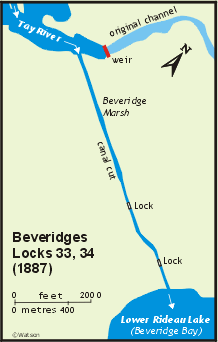
Despite lobbying by the residents of Port Elmsley, the route that would take the canal from Perth to Beveridge Bay was chosen. In 1883, a Federal government order-in-council authorized a contract with A.H. Manning & Macdonald Company for the construction of the Tay Canal. The proposal included deepening the entire system to the required 5.5 foot (1.7 m) depth; cutting a 60 foot (18 m) wide, one and a quarter mile (2 km) long canal to Beveridge Bay; building two locks near the south end of the canal cut, each with a lift of 13 feet (4.0 m); and building a flat overflow dam across the former channel of the Tay near the entrance to the new canal cut.
The locks were built to the same design and specifications as the Rideau locks. They were built without breastworks, gate sluices are present in both the upper and lower gates. The lower lock was built with a lift of 12 feet (3.7 m) and the upper lock with a lift of 13 feet (4.0 m). Started in early 1885, they were completed in 1887. Excavation of this 2nd Tay Canal was done using dredging. In several areas new channels were dug bypassing the original route of the first Tay which followed the river. Final excavation of the canal to the required navigation depth and the basin in Perth were not completed until 1891. For a time, the canal from the Beveridges Locks to Perth became known as "Haggart's Ditch".
An Order in Council dated September 27, 1890 officially made the Tay Canal part of the Rideau Canal, “… declare the now completed Tay Canal to be a part of the Rideau Canal …” (Privy Council Minutes, R.G. 2, Series 1, vol. 459). This implies a completion date of 1890, but while there was vessel traffic on the Tay in 1890, dredging was still continuing to deepen the channel and that work wasn’t completed until 1891.
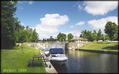 |
Entrance to Lower Beveridges
photo by: Ken Watson, 1999
Looking from the channel connecting Lower Rideau Lake, to the base of the lower lock. |
The Lockmasters to 2000
The first lockmaster was James Cox who served from 1888 to 1889. He was followed by James King who served until 1903, replaced at that time by D. J. Buchanan. Buchanan served until 1924. The next lockmaster was S.W. Jones, tranferred from Smiths Falls Detached. Jones served to 1933 and was replaced by H. Langley. In 1944, W.F. Troy took over, serving until 1965. His replacement was G.A. Hart, followed in 1984 by R.J. Sosnick who served there until 2001.
|