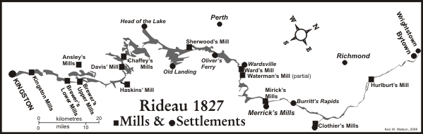
Prolog
Although this history of the Rideau lockstations deals primarily with why and how each lockstation was built, it helps to have some background about the project prior to construction, to set the stage for why this momentous project was undertaken in the first place.
The Rideau project was conceived primarily for the defence of Canada, sparked by the war with the U.S. in 1812. In 1814, when it seemed the war might drag on for years, Sir George Prevost, commander of the military forces in Canada, directed Lt. Colonel George McDonnell (or Macdonnel) to improve the Rapids and roads from Cornwall to Prescott and beyond and "to explore the Rideau communication." A connection from the Ottawa River to Kingston by way of the Rideau was known from an exploration of the region in 1783 by Lieutenant Gershom French, an officer in the Loyal Rangers (also known as “Jessup’s Corps”). McDonnell investigated the Rideau Route in late 1814 and reported to Prevost that a bateau route could be established along the Rideau with the aid of several canal cuts, temporary locks, dams and some portages.
In December 1814, Sir George Prevost, in writing to Lieutenant General Sir Gordon Drummond at Kingston stated that, "In the event of your entertaining apprehensions of the Enemy's interrupting the existing line of Communication from Montreal to Kingston, you will lose no time in giving effect to as much of Lt. Col. McDonnell's project as you shall consider practicable for the purpose of establishing a second route of transport by the Rideau."
In 1815, General Drummond received instructions from London to obtain "estimates of expense of the Lachine Canal, and of the Ottawa and Rideau being made navigable." In April 1816, Drummond dispatched a young Lieutenant of the Royal Engineers, Joshua Jebb, to conduct an exploration of the route for the purposes of this estimate. At the time, two options were being considered. One, the present route of the Rideau Canal through the Rideau lakes, and a second, by way of Irish Creek (located between Merrickville and Kilmarnock), which would cut off the portion of the route through Smiths Falls and the Rideau Lakes. The government was aware of this alternate route since it had been investigated in 1815 by Captain Reuben Sherwood, a land surveyor. Jebb preferred the Irish Creek route, as the "distance is much less, the interruptions by water not so frequent, and the route lies through a more fertile and much better line of country and numerous other advantages might be adduced." In his plan for the Irish Creek route, Jebb noted that “land carriage” would be required for about a five-mile stretch over the summit to the head of the Gananoque River, it would not have been a fully connected waterway. Jebb made his report in July 1816 to the new commander of the Royal Engineers in Canada, Lieutenant-Colonel Durnford.
In February 1817, an advertisement was issued from the Lieutenant-Governor's office in York (Toronto) and published in several papers. It asked for tenders to render the whole or any part of a water communication between "La Chine" and Kingston by the course of the River Rideau, navigable for boats drawing up to three feet (0.9 m) of water and twelve feet (3.7 m) in width. The ad asked for tenders for both the Irish Creek route and for "opening the communication in the direction of the Rideau Lake, and the waters communicating from thence to Mud Lake [Newboro Lake], and from thence to Kingston." The Lieutenant-Governor's office was underwhelmed with the response. There was no interest in this project. Threats of war seemed to have ended and thoughts had turned strictly to commerce. For commerce purposes, the St. Lawrence River was much more attractive, and efforts were being made to render it more navigable. However, the Royal Engineers, concerned with matters of defence rather than commerce, continued to investigate various military routes, including the Rideau.
George Ramsey, the 9th Earl of Dalhousie, became Governor of British North America in late 1820. Dalhousie was presumably influenced by his mentor, the Duke of Wellington (who defeated Napoleon at the Battle of Waterloo in 1815). The Duke (who was later to become Prime Minister of England) was at that time the head of the military Ordnance Department. Wellington was keen on the Rideau as a line of military communication and defence, and had been instrumental in establishing the settlements of Richmond and Perth, made up of retired military personnel.
Dalhousie made a trip up the Ottawa River after the ice broke in 1820. In Richmond, he expounded on the importance of the Richmond Landing area (on the south side of the Ottawa River near the base of the Chaudière Falls) as an essential debarkation point for settlers arriving in this area. He commanded the Superintendent of Settlers in Richmond to "take steps to affect the purchase, and to watch any advertisement of the sale of it, but to report to me before he concluded" [the purchase]. A retired officer, Captain LeBreton, who had been present at the dinner where Dalhousie had stressed the importance of the Richmond Landing area, bought, a few months later, 400 acres of land in the area of Richmond Landing, offered at a public sale. He then offered to sell this land to Dalhousie at a price five to eight times greater than what he had paid. It was later said that this influenced Dalhousie on where not to place the head of the Rideau Canal.
Dalhousie also asked his Lieutenant-Governor of Upper Canada, Sir Peregrine Maitland, to advise on ways the government might obtain various pieces of land fronting the Ottawa. In June 1823, Dalhousie purchased 150 acres of land from Hugh Fraser, occupying what is now known as Entrance Valley, the head of the Rideau Canal.
In 1821, the Provincial Legislature initiated a commission to look into the building of canal routes in Upper Canada. This commission was headed up by Captain John Macaulay of Kingston. It was principally concerned with the St. Lawrence and Welland routes. Samuel Clowes, the commission's civil engineer, later told Colonel By that the commissioners sometimes made him feel that with the Rideau, he should simply be going through the motions. The commissioners obviously were not keen on developing the Rideau route.
Samuel Clowes made a detailed survey of the Rideau route in 1823 and 1824 recommending the Rideau Lakes route over the Irish Creek route, which had been recommended in 1816 by Lt. Jebb. There were a couple of reasons for this recommendation. One was the lack of sufficient reservoir water to maintain a canal system on the Irish Creek route. To get sufficient water, a ten mile feeder canal would have to have been cut, at great expense, from Rideau Lake. Another reason was that the Irish Creek route had originally been perceived to be lower in elevation than the Rideau route, but Clowes' survey indicated that the summit point, near Plum Hollow, was actually 2.4 feet higher than Rideau Lake.
Clowes made estimates for three sizes of locks, the first 7 feet (2.1 m) deep by 100 feet (30.5 m) long by 22 feet (6.7 m) wide, the second 5 feet (1.5 m) deep by 80 feet (24 m) long by 15 feet (4.6 m) wide, and the third, 4 feet (1.2 m) deep, with timber locks 75 feet (23 m) long by 10 feet (3 m) wide. His cost estimates ranged from £230,000 for the largest to £62,000 for the smallest lock size.
Clowes' report was examined in London, and eventually tabled as part of the Macaulay Commission's final report on "inland navigation" in the Upper Canada Legislature in April, 1825. The British Government offered the Provincial Legislature a loan of £70,000 to go ahead with the Rideau project. The Legislature refused, citing prior commitments with the St. Lawrence route. Rebuffed, the British Government instructed an existing commission under the direction of General Sir James Carmichael Smyth, which was investigating Canada's military defences, to investigate the Rideau route and make recommendations.
Smyth recommended that Clowes' second estimate be adopted, with the modification that the locks be increased in size to 108 feet (33 m) long by 20 feet (3 m) wide with a depth of 5 feet (1.5 m). To compensate for the increase in lock size he added £500 per lock, increasing Clowes' estimate of £145,000 to £169,000. It seems that Smyth knew that Clowes' estimates had been low to encourage the project, but he didn't want to ruffle too many provincial feathers, and mollified them by essentially adopting the provincial commissions' (Clowes') recommendation.
The Rideau project was placed under the control of the British Board of Ordnance which was responsible for fortifications and canals. The Inspector-General of Fortifications was Gother Mann. It was Mann who likely recommended that Lieutenant Colonel John By, a retired officer of the Royal Engineers, be placed in charge of the project. By had worked under Mann, in Canada, earlier in the century. By had been retired in 1821 at the young age of about 40*. In March 1826 he was taken out of retirement and appointed Superintending Engineer of the Rideau Canal.
It is worth noting that shortly after Lt. Colonel John By was appointed Superintending Engineer, he said that the estimate given by Smyth was too low by a factor of four or five, based on the costs of building the Lachine Canal. Cost overruns, based on initial low construction cost estimates, would later become a major problem for Colonel By.
In March 1826, Major General Sir James Carmichael Smyth wrote a memorandum to General Mann (Inspector-General of Fortifications) which read in part, "I am of the opinion that it will be found more economical and more expeditious to execute the greatest part, if not the whole, of the proposed Rideau Canal by contract …" This presumably had some influence on the fact that most of the Rideau Canal was eventually built by contractors, although the engineering was performed by officers of the Royal Engineers since Colonel By didn't believe that civilian engineers were as reliable as those trained at the Royal Military Academy.
By and his family departed London aboard the bark Endeavour on April 23, 1826 and landed at Quebec City on May 30. On June 1 By and family took the steam boat New Swiftsure to Montreal. In July 1826, he wrote to General Mann in England. In the letter he stressed the need to make the Rideau a route suitable for steamboat navigation, that such boats would become increasingly important from a military standpoint. This meant that the locks should be made to accommodate boats up to 130 feet (40 m) in length and 50 feet (15 m) in width.
By fell sick in Montreal, as did his assistant, Captain Daniel Bolton of the Royal Engineers, and it was not until September that By could travel up the Ottawa. During that time, John Mactaggart, who had been appointed by the Ordnance in London to act as By's Clerk of Works, arrived in Montreal.
On September 7, 1826, the Commanding Royal Engineer in Canada, Colonel Dunford, received specific instructions from the Ordnance in London for By to proceed with the building of the Rideau Canal.
In mid-September 1826, By and a young Royal Engineer, Lieutenant Henry Pooley, together with several other assistants, including John Mactaggart, travelled to Wright's Town, arriving there on September 21. By and Pooley spent several days on a "minute inspection of the various bays" near the Rideau's mouth and "decided on the upper as best." By's choice was Sleigh Bay, later known as Entrance Bay. This also happened to be Dalhousie's choice. The valley above Sleigh Bay was land he had purchased on behalf of the government from Hugh Fraser three years previously. On September 26, Dalhousie and Durnford arrived at Wright's Town and went over the ground with By, approving of what he had done.
Colonel By again requested that consideration be given to larger locks, 150 feet (46 m) long by 50 feet (15 m) wide by 10 feet (3 m) deep (he later modified this to 5 feet (1.5 m) deep). Before he returned to Montreal in November, By initiated the building of a bridge across the Ottawa River to Wright's Town (by contractor Thomas McKay) and the clearing of the trees in Entrance Valley, and journeyed to Kingston to review the planned route of the canal with Samuel Clowes.
Colonel By selected the final route for the canal in the fall of 1826. Jebb's shortcut via the Irish Creek Route had already been discounted by Clowes and By only looked at the Rideau Lakes route. While he used Jebb's maps as his main basemaps, he based the route on Clowes' recommendations except for the methodology (slackwater method vs Clowes' canal cuts with tow paths method) and starting the canal in Entrance Valley rather than Rideau Falls. Tenders were placed in the papers in Canada and the U.S. in December 1826. By insisted that no contractor be given more work than he was capable of completing in a two year period. So the canal was divided into 23 sections, ranging in length from 1 ¾ miles to 29 ¼ miles (3 km to 47 km), each with its own contractor.
In January 1827 Colonel By made a quick tour of the route with several potential contractors. It was not until May 1827 that By made his first extensive survey tour of the Rideau route. He completed plans for all the works at that time and made a new estimate of costs, £474,844. He sent his report to England in the care of Lt. Henry Pooley, who travelled to London to present By's plans and estimates. Pooley also took with him By's formal request for larger locks. By's plans were reviewed by a board of senior officers, headed by Major General Alex Bryce. They were generally approved, with some minor modifications.
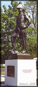 |
Statue of John By
located in Major Hill Park, Ottawa |
The size of the locks was still an issue, and so a committee was set up, headed up by Lieutenant General Sir James Kempt, Lieutenant-Governor of Nova Scotia. The Kempt Committee toured the route with By in the spring of 1828, completing their report in Kingston by the end of June of that year. The Committee approved of locks 134 feet (40.8 m) long, by 33 feet (10.1 m) wide, with 5 feet (1.5 m) of water over the sills. They also approved the dismantling of existing masonry works, started in 1827, in order to accommodate the larger size of lock. The revised estimate for the work was £576,757. John By's actions were also approved by the commission, stating in their official report, "Economy has not been lost sight of by Colonel By and he had, in accordance with what he believed to be the spirit of his instructions, pushed forward the work and excited a degree of exertion through the whole Department which few individuals could have accomplished."
The final cost of the canal, by the time all the costs, including land acquisition had been added up, was £822,804 (January 1834 figure). On May 25, 1832, the day that Colonel By was passing through Smiths Falls aboard Robert Drummond’s steamboat, “Rideau” (better known by its nickname of "Pumper"), on the grand opening cruise of the newly completed Rideau Canal, a Treasury Minute was being written in London, England. This Treasury Minute ordered that Colonel By be removed from duty and be recalled to England to stand before the Lord Commissioners of the British Treasury to explain why expenditures had exceeded those allowed by the Parliamentary grants. It took some time for the recall to be communicated to Colonel By and on September 1, 1832, superintendence of the Rideau Canal was handed over to Captain Daniel Bolton. By and family set sail from Québec City aboard the troopship Brothers on October 21 and arrived in Chatham, England on November 25, 1832.
Before Colonel By arrived back in England, a parliamentary committee was established and an inquiry was held. It should be remembered that this was the time of parliamentary reform in Britain. Parliament was not so much upset at the cost overrun as they were at the Ordnance's defiance of parliamentary authority by authorizing By to complete the project regardless of the actual amount of the parliamentary grants. By was caught in the middle of a political battle. By never had to stand before a Parliamentary Committee. A committee reviewed evidence and exonerated By of all wrongdoing prior to his arrival back in England. However, a victim of the politics of the day, By never received formal commendation in recognition of the tremendous feat he had accomplished. Colonel By died in 1836 at the age of 53**, his achievements, the building of the Rideau Canal and the founding of Bytown (Ottawa), not publicly recognized.
This book will not deal with the costs and politics of the building of the canal. These have been well documented in such books as Legget's "Rideau Waterway" and Andrews' "For King and Country, Lieutenant Colonel John By, R.E., Indefatigable Civil-Military Engineer." The details of Colonel By's fall from grace are summarized in the story "Bye By" in Watson's Tales of the Rideau.
* There is some controversy over the birth year of Colonel John By. Legget and Passfield (presumably based on Legget) have him as being born in 1779. Previous researchers placed his birth year as 1781. Andrews has him as being born in about 1783. I lean towards Andrews' date. A memorial plaque to By, approved by his widow Esther, states that he was 53 when he died in 1836 (hence the 1783 date). However Legget documented a baptismal certificate dated August 10, 1779 for John By, son of George By and Mary Bryan. Andrews points out that there is information of five infant deaths in the By family, including information that the John By born in 1779 died as an infant. As was common in those days, the next surviving child would take on the same name as the previously deceased child (that name would continue to be given until a child finally survived).
** If he was born in 1779, then his death in 1836 would have been at about age 57.
A Few Interesting Notes
Slackwater Canal System
The Rideau Canal is referred to as a slackwater canal system. This means that a navigable depth of water was created by building dams which changed flowing water into still water (slackwater). Although previously used to a limited extent in Europe (i.e. Gotä Canal in Sweden), it was not the canal building convention of the day. Most canals were created by digging channels around navigation impediments such as rapids.
This technique had a number of advantages, most notably cost savings. Samuel Clowes, who surveyed the Rideau Route in 1823 and 1824 and followed the standard design of the day by proposing canal cuts and tow paths, noted the cost advantage of a slackwater system in the area between Upper Brewers and Jones Falls. In his survey report he stated "In connecting the Canal at the Round tail [just above Upper Brewers] with the Gananoque River, the Engineer might either make a cut across the intervening flats, or by Dams at the outlets he might convert them into one extensive Lake, comprising Cranberry Lake, and another smaller one in its vicinity. ... The whole expense [of cutting a channel] is therefore estimated in the aggregate for the nine miles and a half at £25,650. By the latter plan [using dams] the water would be raised to a depth of seven feet over the whole surface of the flats to the foot of Jones's Rapids. The expense of forming waste weirs at the Round tail and Whitefish falls, clearing the timber from the direct line of the canal on the flats, would amount to £725 - and as the difference between the two plans amounts to £24,925, the advantage of inundating the tract instead of cutting through it, obtains a decided superiority."
During his survey Clowes saw the slackwater system in operation since millers had erected mill dams at White Fish Falls (today's Morton) and at the Round Tail (near Upper Brewers). These mill dams had created a navigable lake in an area previously covered by forest. Clowes recommendation was to replace these mill dams with canal dams. Colonel By would have been aware of previous slackwater systems and Clowes' report. He saw that the three rivers along the Rideau Route, the Rideau River, the White Fish River, and the Cataraqui River, were small enough to be spanned by dam building techniques of the day, allowing the entire Rideau Canal to be done as a slackwater system.
A second advantage of using the slackwater system was that it allowed most of the Rideau locks to be built "in the dry." In other words, they were built above the pre-canal water level. This meant that building coffer dams and pumping out water was not necessary for most of the locks, the exception being the river locks; the lower lock at Ottawa (below the level of the Ottawa River) and the lower lock at Kingston Mills (below the level of Lake Ontario). An example is Davis Lock which was built in the bank of the river (rapids) channel between Opinicon Lake and Sand Lake. The bottom of the lock and the lower sill are above the pre-canal level of Sand Lake. The building of the lock was completed just before the water in Sand Lake was raised by the completion of the dam and weir at Jones Falls. This raised the level of the lake by 8 feet (2.4 m) and put a navigation depth of water over the lower sill at Davis Lock.
A third advantage was that it reduced the amount of hard rock excavation, of which there would have been a great deal if canal cuts had been used to bypass all the rapids. At the time, rock excavation was done using pry bars and black powder blasting, which were slow and sometimes dangerous procedures.
There were downsides to the technique. Land was flooded and in the case of the Rideau, most of that land was owned, granted to United Empire Loyalists. The Rideau Canal Act, passed in 1827, allowed Colonel By to acquire land for canal purposes, with compensation to be settled by arbitration (see "Acquiring Land" below). Those costs were still much less expensive than doing canal cuts around every set of rapids.
Another downside of a slackwater system is that it makes it very difficult to create tow paths alongside the canal. The paths were used to tow boats, generally using a horse, ox or donkey, along the canal. Samuel Clowes, in his proposal for the canal, had tow paths along the length of the route. But Colonel By was building a steamboat canal for boats that were either self propelled, or in the case of barges, pulled by a self propelled boat (i.e. a steam tug). He didn’t need tow paths.
Who Built the Rideau?
The obvious answer to this is the British Ordnance Department under the direction and supervision of Lt. Colonel John By. But it was much more complex than just that - it was a collaborative effort that involved many groups of people.
Royal Engineers: Lt. Colonel John By was a Royal Engineer trained in both combat and construction engineering. He had several other Royal Engineers under his command, who were stationed at various worksites along the canal to oversee the work and to administer the construction contracts.
Ordnance and Commissariat Staff: the construction was a mammoth project and required all sorts of skill sets including surveyors, masons, carpenters, accountants and support staff. Although the project was done by contractors, the work of those contractors had to be overseen. All the engineering design was done by the Royal Engineers and their support staff. There were master masons and master carpenters who oversaw the quality of the contractors' work. Payment to contractors was done by cheque through the Commissariat. The Commissariat ensured that payment to the contractor's workers was in cash, in the form of coins (ironically, given the military nature of the canal, in American half-dollar silver coins which the Commissariat obtained for the contractors to use to pay their workers).
Royal Sappers and Miners: Two companies of Royal Sappers and Miners served on the Rideau Canal and directly worked on the construction of three lockstations. See the separate Royal Sappers and Miners section.
Contractors: the actual construction of most of the lockstations on the Rideau Canal was carried out by independent contractors who hired their own crews. Some made good money, some went broke. Contractors such as Thomas McKay and John Redpath are well known today, others have been lost to history.
Tradesmen: the contractors needed many skilled trades such as masons, carpenters, blacksmiths and miners. These were from various backgrounds, English and French Canadian, as well as skilled workers recently arrived from the British Isles. Contractors would often run ads in local (i.e. Kingston, Brockville) papers advertising for skilled trade positions.
Labourers: there was almost no machinery used during the building of the Rideau Canal. Excavation and construction was done by hand (picks, shovels and axes) with the aid of a few draft animals (horses and oxen). This labour force consisted mostly of French Canadians and recently-immigrated Irish. Some contractors such as Philemon Wright and John Redpath used labour forces they already had at hand, mostly French Canadian. Other contractors had to make use of any available willing hand, mostly Irish immigrants.
Women and Children: all the work sites had a number of women (mostly wives of workers) and children on site. Some of these helped with the project, for instance at Hogs Back there are references to gangs of boys hauling water. Little is known of their full role in aiding the construction of the canal.
Local Settlers: much of the Rideau in 1826 could be characterized as a frontier rather than wilderness. There were several small settlements and a number of settlers operating farms along the route. These settlers contributed to the project in several ways such as selling meat and produce to the contractors and using their wagons and oxen to haul stones to some of the worksites.
Indigenous People: there is no evidence indigenous people were involved in the project – they continued to use the Rideau as they traditionally did, as seasonal hunting and fishing grounds, during construction of the canal. The two groups, those building the canal and indigenous people can best be described as two solitudes.
-------------------
Death during the construction of the Rideau Canal
A mythology has been built up over the years that implies a callous disregard for workers who died during the building of the Rideau Canal. This view is untrue, death was treated back then much as it is today, they adhered to the conventions of the day as much as conditions would allow. Most of the deaths during the building of the canal were due to disease, primarily complications that arose from a temperate form of malaria (prevalent throughout southern Ontario at the time - see Appendix 3). When a worker died a funeral was generally held and the grave site marked with a wooden marker. If a worker died by accident rather than disease, an inquest was held.
-------------------
Size of the Locks
Throughout this document, the lock size is referred to as being 134 feet (40.8 m) long by 33 feet (10.1 m) wide. This is the full length of the lock from the point of the upper sill to the point of the lower sill. The lock is actually 124 feet (37.8 m) long in the chamber, measured from the point of the lower sill to the face of the breastwork. The lower gates require 13 feet (4.0 m) of room for their swing, so if a vessel is to take up the full length of the lock, it has to be less than 111 feet (33.8 m) long. Since the sides of the lockwall slope inward, the maximum allowable width of a vessel is 31.5 feet (9.6 m). This final size fits with the Kempt Committee's recommendations, which were for locks with a 5 foot (1.5 m) navigation depth, wide enough for steamboats 30 feet (9.1 m) wide over the paddle boxes, and long enough for spars (logs) 108 feet (32.9 m) long, with ample space for working the gates.
After the Kempt report was released on June 28, 1828, By proposed that the locks be 134 (40.8 m) feet long in the chamber to accommodate 130 foot (39.6 m) long spar timbers which were being exported from the Rideau at that time. However this dimension was protested by Lt. Colonel Fanshawe of the Royal Engineers who noted that it didn't fit with any of the vessels that were intended to make use of the Rideau Canal. So By reduced the size by 10 feet (3.0 m), creating the size of lock we see today, 124 feet (37.8 m) long in the chamber, which, allowing for the gate swing, can accommodate vessels up to a maximum of 111 feet (33.8 m) in length. For more information about the locks see Appendix 4, Lock Basics.
-------------------
Hydraulic Cement
Much of the hydraulic cement used on the canal came from Philemon Wright of Hull. In 1829, Ruggles Wright, Philemon's son, discovered limestone near Wright's Town that made ideal hydraulic cement. Lieutenant Frome of the Royal Engineers stated, "the cement (Hull Cement) was made from a stone quarried on the opposite side of the Ottawa, which, being burnt and ground very fine, proved a better water-cement than some obtained from the States, and far superior to the Harwich (English) cement, which was nearly spoilt before it reached the Canal."
-------------------
Iron Supply
Much of the iron, particularly cast iron items, were supplied from Bell's Foundry near Three Rivers, Lower Canada (Forges du Saint-Maurice National Historic Site of Canada, Trois-Rivières, Québec). The reason for this was, "Experience has shown, that the Iron of this Country is much superior to the English … my preference arises from the Metal in this Country being melted with Charcoal, and absorbing a portion of the Carbon, renders it tough and more malleable than the English Iron which is melted with Sea Coal" - letter from Colonel Durnford to General Mann.
-------------------
Acquiring Land
Acquiring land proved to be a constant headache for Colonel By. The British initially hoped that the Province of Upper Canada would provide land for use by the canal, free of charge. This didn’t work out and the project moved ahead so fast that land purchases could not be made prior to the commencement of the works. In a very few cases, people such as Nicholas Sparks actually donated land for use by the canal, realizing that they stood to reap economic benefit from having the canal pass through their lands. However, most were not so generous.
In February 1827, Upper Canada passed the Rideau Canal Act, which allowed By to acquire all lands required for the canal. It was not done by expropriation, the amount of compensation was to be determined by arbitration following the construction of the canal. By still had problems since the Act did not allow the acquisition of land for defence purposes, and the detailed surveying required to determine exactly which land would be drowned by the canal works was difficult, time consuming and expensive. In the central Rideau, the problem of land acquisition was compounded by the number of absentee land owners. Many were United Empire Loyalists who had been granted land, but had never occupied it.
To help speed up the process, By created a system where he would purchase land, and then lease it back to the landholder for 30 years, at a rate of five percent of the purchase price per year. This allowed By to much more easily buy land, without having to resort to an arbitrated settlement (and the associated time and costs involved). It resulted in By acquiring much more land than he needed, but the system worked well, resulting in few delays in canal construction.
In some areas, such as Merrickville, By was able to bypass existing milling facilities, avoiding the need to purchase these to make way for the canal. In other places, such as Chaffey's Mills and Davis' Mill, By, with costs mounting and time running out, found it more expedient to simply buy out the mill owner and place the canal where the mill had been located.
Lands acquired during the construction of the Rideau remained in the possession of the British Ordnance Department until 1856, when the canal and all associated lands were transferred to the Province of Upper Canada.
-------------------
Lock Maintenance
It is somewhat ironic that the current historic integrity of the Rideau Canal is in part due to the tight-fisted economic policies of various government departments that have been in charge of the Rideau over the years. Time and time again in the records, requests for funding to replace ageing canal works were turned down. This led to a series of jury-rigged repair solutions, which kept a great deal of the original historic fabric intact. It is testimony to the original quality of construction and to the ingenuity of canal staff over the years, that, given the minimal amount of funds allocated to repair and maintenance, the canal has been able to stay in continuous operation, with only a few months of "downtime" at various individual lockstations, since 1832.
-------------------
Royal Sappers and Miners
Colonel By requested four companies of Royal Sappers and Miners*, but ended up with only two, the 7th and 15th, totalling 162 men. Desertion was common in those days, since many men were "pressed" into service (sort of like the draft). The 7th and 15th Companies under By had a relatively low desertion rate with only 35 deserting during the construction of the canal (1827 to 1831). An example is between June 1827 and November 1828, when some 16 men deserted. Three of these were caught and sentenced to seven years. Colonel By kept the desertion rate low by promising land grants to those men who wished to settle in the area when the canal was completed. In addition to the 35 who deserted, 22 died during the construction of the canal (16 from disease (about half of those from malaria), 6 from accidents).
The Royal Sappers and Miners were first used as soldiers, to keep order on various worksites. But contractor problems at Newboro and Hogs Back forced Colonel By to take over those two projects. At these sites the Royal Sappers and Miners, along with civilian workers, plied their various trades.
At the end of construction, some 71 Sappers and Miners took land grants offered by Colonel By and settled in the Rideau area. Many of the first lockmasters came from the ranks of the Royal Sappers and Miners.
* A Sapper is a military man with skills in excavation and a miner is a man with mining skills, generally including black powder blasting. Sapping is the excavation of a trench or tunnel to approach and undermine a fortification. At the time of the building of the Rideau Canal, the Royal Sappers and Miners had many trade skills including carpentry, masonry, and blacksmithing in addition to their traditional excavation and mining skills.
|