Your location: Rideau Canal Home Page > Ecology of the Rideau > Water Sampling Results

Water Sampling Program Results
For the past several years, a water quality survey known as the Lake Partner Program (formerly known as the Cottagers Self Help Program) has been administered by the Ministry of Environment and Energy. It involves volunteers taking visibility depth readings and water samples on a regular basis throughout each summer. Visibility depths are measured with a Secchi disc and the water samples are measured for concentrations Phosphorus (prior to 1996 for Chlorophyll A). The collecting of this data is done by volunteers.
The table below shows how to interpret the results:
| Lake Nutrient Status |
Secchi Disc
(metres) |
Chlorophyll
(ug/L) |
Phosphorus
(ug/L) |
Oligotrophic
(unenriched - few nutrients) |
greater than 5 |
2 or less |
10 or less |
Mesotrophic
(moderately enriched - some nutrients) |
3 - 5 |
3 - 5 |
11 - 20 |
Eutrophic
(enriched - higher levels of nutrients) |
less than 3 |
6 or more |
21 or more |
Sand Lake - Data Table
Sample Date
(year) |
Secchi Depth
(metres) |
Chlorophyll A
(ug/l) |
Calcium (Ca)
(mg/l) |
Chloride (Cl)
(mg/l) |
| 1971 |
2.9 |
2.5 |
|
|
| 1975 |
3.7 |
5.7 |
|
|
| 1980 |
3.0 |
7.2 |
|
|
| 1983 |
2.7 |
3.3 |
|
|
| 1984 |
2.8 |
5.2 |
|
|
| 1985 |
3.4 |
5.1 |
|
|
| 1986 |
3.0 |
4.5 |
|
|
| 1987 |
3.5 |
3.0 |
|
|
| 1988 |
4.0 |
3.6 |
|
|
| 1989 |
3.5 |
4.2 |
|
|
| 1990 |
3.3 |
5.2 |
|
|
| 1991 |
3.5 |
3.1 |
|
|
| 1992 |
4.7 |
2.3 |
|
|
| 1993 |
3.6 |
2.4 |
|
|
| 1994 |
4.0 |
2.9 |
|
|
| 1995 |
3.4 |
3.9 |
|
|
| |
|
Phosphorus |
|
|
| 1996 |
3.9 |
16.5 ug/L |
|
|
| 1997 |
4.3 |
10.0 ug/L |
|
|
| 1998 |
4.0 |
18.0 ug/L |
|
|
| 1999 |
4.7 |
10.0 ug/L |
|
|
| 2000 |
4.6 |
13.0 ug/L |
|
|
| 2001 |
5.6 |
12.0 ug/L |
|
|
| 2002 |
5.7 |
13.9 ug/L |
|
|
| 2003 |
5.1 |
15.4 ug/L |
|
|
| 2004 |
5.5 |
13.8 ug/L |
|
|
| 2005 |
6.3 |
12.6 ug/L |
|
|
| 2006 |
4.9 |
14.7 ug/L |
|
|
| 2007 |
6.5 |
10.1 ug/L |
|
|
| 2008 |
5.9 |
11.9 ug/L |
24.3 mg/L |
|
| 2009 |
5.7 |
10.7 ug/L |
25.6 mg/L |
|
| 2010 |
6.0 |
12.1 ug/L |
25.6 mg/L |
|
| 2011 |
4.0 |
15.3 ug/L |
22.7 mg/L |
|
| 2012 |
5.3 |
12.4 ug/L |
23.9 mg/L |
|
| 2013 |
5.8 |
11.0 ug/L |
24.6 mg/L |
|
| 2014 |
4.6 |
13.1 ug/L |
23.4 mg/L |
|
| 2015 |
4.9 |
13.7 ug/L |
25.3 mg/L |
|
| 2016 |
5.8 |
11.9 ug/L |
24.9 mg/L |
|
| 2017 |
4.7 |
13.4 ug/L |
24.2 mg/L |
7.0 mg/L |
| 2018 |
4.9 |
13.8 ug/L |
24.8 mg/L |
6.4 mg/L |
| 2019 |
5.0 |
14.2 |
25.2 |
6.5 |
| 2020 |
5.4 |
18.4* |
23.6 |
6.8 |
| 2021 |
4.8 |
11.0 |
24.5 |
7.4 |
| 2022 |
4.6 |
13.5 |
24.7 |
6.7 |
| 2023 |
4.8 |
15.0 |
24.3 |
6.3 |
| 2024 |
5.2 |
13.7 |
24.3 |
7.2 |
Sample Date
(year) |
Secchi Depth
(metres) |
Phosphorus
(ug/l) |
Calcium (Ca)
(mg/l) |
Chloride (Cl)
(mg/l) |
* Sampling was restricted in 2020 to 1 late season sample due to COVID - so the number is not comparable to previous years. It is slightly higher than the recent October sample average of 15.9 ug/L.
Seasonal Variations in Phosphorus - Sand Lake
Phosphorus promotes vegetation growth. Too much leads to excessive aquatic vegetation growth which is evident in many Rideau lakes. This phosphorus loading shows seasonal variations. The largest contributor to phosphorus in the Rideau area lakes is agriculture in the watershed, excess fertilizer going into the drainage systems that then end up in our lakes. The numbers increase by August each year, representing both phosphorus entering the lakes and generally lower water flow (less "flushing out" of those excess nutrients).
| Year |
May |
June |
July |
Aug |
Sept |
Oct |
| 2015 |
8.3 |
15.7 |
12.1 |
15.2 |
13.5 |
17.4 |
| 2016 |
7.4 |
9.4 |
10.3 |
14.0 |
14.7 |
15.8 |
| 2017 |
10.3 |
13.3 |
12.9 |
14.1 |
14.7 |
14.9 |
| 2018 |
11.6 |
11.7 |
13.8 |
15.4 |
15.5 |
14.8 |
| Average |
9.4 |
12.5 |
12.3 |
14.7 |
14.6 |
15.7 |
Water Clarity Charts - Sand Lake |
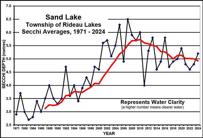 |
Secchi Chart
The Secchi disk reading represent water clarity. A larger number means more (better) clarity. Yearly fluctuations are evident, presumably based on weather. The red line is an 8-year moving average. The jump in the upward trent is due to a zebra mussels population explosion in 2001. By the late-2000s zebra mussels populations were stabilizing at lower numbers and the lake appears to be returning to "normal" clarity. |
Rideau Region Lakes
| Lake |
2000 |
2001 |
2002 |
2003 |
2004 |
2005 |
2006 |
2007 |
2008 |
2009 |
2010 |
2011 |
2012 |
| |
Secchi (metres) |
| Beverley - Lower |
2.1 |
2.4 |
2.8 |
3.0 |
2.8 |
3.0 |
3.0 |
3.2 |
3.0 |
3.1 |
3.2 |
3.5 |
4.0 |
| Beverley - Upper (outlet) |
2.3 |
1.8 |
3.0 |
2.8 |
2.7 |
2.7 |
2.7 |
2.7 |
2.4 |
2.9 |
-- |
2.8 |
-- |
| Big Rideau |
6.4 |
6.4 |
6.2 |
-- |
-- |
8.0 |
6.8 |
7.0 |
6.5 |
-- |
-- |
-- |
8.0 |
| Bobs |
4.0 |
4.7 |
4.3 |
4.7 |
4.7 |
4.6 |
4.6 |
4.9 |
4.9 |
5.0 |
4.8 |
5.2 |
5.4 |
| Buck - S. End |
6.3 |
6.8 |
5.5 |
6.0 |
5.8 |
4.9 |
-- |
-- |
5.0 |
4.7 |
4.5 |
-- |
4.5 |
| Buck - N. Bay |
4.0 |
4.2 |
3.4 |
3.5 |
3.3 |
3.3 |
3.4 |
3.0 |
3.0 |
3.2 |
3.1 |
2.8 |
3.2 |
| Charleston |
4.3 |
4.4 |
3.9 |
4.3 |
4.7 |
5.5 |
5.7 |
6.6 |
6.2 |
6.8 |
8.1 |
6.9 |
8.1 |
| Clear |
|
|
|
|
|
|
|
|
|
|
|
|
|
| Devil |
6.5 |
6.8 |
6.1 |
6.8 |
6.6 |
7.0 |
6.4 |
6.2 |
5.5* |
5.9 |
6.3 |
6.7 |
6.8 |
| Dog (north) |
-- |
3.4 |
2.6 |
3.2 |
2.8 |
2.8 |
-- |
3.1 |
-- |
3.0 |
2.8 |
-- |
3.1 |
| Dog (south) |
-- |
-- |
2.4 |
-- |
1.3 |
1.9 |
1.7 |
1.8 |
1.8 |
1.5 |
1.5 |
1.0 |
1.1 |
| Indian |
3.8 |
4.8 |
4.9 |
5.8 |
5.6 |
5.6 |
5.4 |
6.0 |
5.9 |
6.4 |
4.9 |
5.5 |
-- |
| Newboro |
3.3 |
3.8 |
5.0 |
5.6 |
5.5 |
5.7 |
6.0 |
5.8 |
5.4 |
5.6 |
5.7 |
5.3 |
5.6 |
| Opinicon |
4.1 |
4.1 |
5.1 |
4.8 |
4.6 |
4.1 |
4.8 |
4.5 |
4.6 |
5.4 |
5.1 |
3.4 |
3.9 |
| Otter |
3.4 |
4.0 |
3.5 |
6.5 |
-- |
-- |
7.1 |
-- |
-- |
-- |
5.2 |
-- |
5.5 |
| Otty |
4.3 |
4.7 |
4.3 |
4.7 |
5.1 |
4.9 |
4.9 |
5.6 |
5.2 |
6.1 |
5.5 |
5.2 |
6.1 |
| Sand |
4.6 |
5.6 |
5.7 |
5.1 |
5.5 |
6.3 |
4.9 |
6.5 |
5.8 |
5.7 |
6.0 |
4.0 |
5.3 |
| Troy |
2.4 |
1.8 |
1.6 |
1.9 |
2.2 |
2.2 |
2.2 |
2.2 |
1.7 |
1.3 |
1.6 |
1.4 |
1.5 |
| Upper Rideau |
3.6 |
4.2 |
4.1 |
4.2 |
4.4 |
4.0 |
4.1 |
4.8 |
4.3 |
4.7 |
4.3 |
3.4 |
3.3 |
| Whitefish |
-- |
-- |
-- |
-- |
4.2 |
4.3 |
4.7 |
4.1 |
-- |
4.3 |
3.8 |
-- |
3.1 |
| Wolfe |
7.9 |
8.0 |
6.2 |
6.0 |
-- |
6.7 |
-- |
-- |
-- |
-- |
-- |
7.8 |
6.5 |
| Secchi = bigger number = better clarity |
Bolded names are lakes on the Rideau Canal Waterway
*only partial sampling of Devil Lake in 2008 (non comparitive with previous years) |
Note: I'm no longer updating this table. You can see current data on the Lake Partner website (data.ontario.ca/dataset/ontario-lake-partner) and current data for Sand Lake is shown above. Zebra mussels have leveled off at a level much lower than their initial invasion - presumably they are now in balance with the local ecosystems.
The poor values from Upper Rideau Lake in 1994 and 1995 represent sewage lagoon discharge from the Village of Westport. An innovative sewage treatment system, involving the freeze misting of sewage lagoon effluent was installed in 1996. The improved readings in 1997 are presumably a result of this treatment system. However, problems with this system led to overflow discharges in the mid-2010s. A new waste treatment system was built in 2017 which will hopefully prevent any further discharges into Upper Rideau Lake.
In the Rideau Waterway, Big Rideau, which is a deep lake the top of the watershed, has some of the best values. Sand Lake, further down the waterway, and also shallower and warmer than Big Rideau, has poorer (though still good) water quality. The lower lakes (Whitefish, Cranberry, River Styx, Colonel By) are all shallow man-made lakes and suffer from excessive nutrient loading.
The growth of algae in the water depends on nutrients such as phosphorus and nitrogen. A certain level of algae is desirable, it supports fish populations and other aquatic life. However, the introduction of excess phosphorus and nitrogen, primarily from agriculture and urban development, leads to excess algae growth, and instead of nurturing a lake, it chokes it. Improved agricultural methods and proper home environmental maintenance (properly maintained septic system, minimal use of fertilizers, non-use of phosphorus containing detergents) will over time, improve the water quality of our lakes.
Zebra mussels have had a dramatic impact. Zebra mussels filter the water, removing algae, and greatly improve the clarity of the water. This is not always a good thing, improved clarity means that rooted aquatic vegetation can now exist in deeper water (deeper sunlight penetration), expanding their range. Zebras also only filter single celled algae, not filamentous algae, changing the balance of those two types of algae (leading to invasions of green blobs, which are made up of filamentous algae).
The first reported sightings of Zebra mussels in Sand Lake was in 1998 (a few veligers). They exploded in the lake (tens of millions) in 2001. The effect of this explosion of zebra mussels was clearly seen in Sand Lake and Indian Lake in 2001 with a 20%+ increase in water clarity. Zebra mussel populations in Sand Lake started to level off in 2008 (at levels lower than the initial "invasion), presumably having achieved a balance between population and yearly food availability. Water clarity is returning to longer term, pre-zebra trend levels.
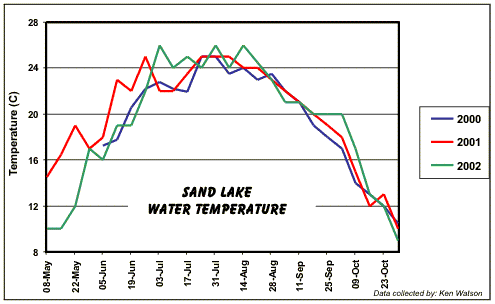
Water Temperature
Water temperature is measured as part of the Lake Partner program. The chart below shows the 2000 to 2002 results from Sand Lake with temperatures taken at 1 metre depth in mid-lake. In the case of Sand Lake, the water temperatures reach a nice 20C by mid-June and stay that way until mid-September. The temperature peaks in mid-summer at 25C (77F).
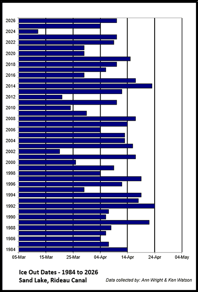
Ice Out
Another item of interest to many waterfront dwellers and cottage owners is when the ice goes out on their local lake. The following chart is data collected for Sand Lake over the last 43 years. In 2026 the ice went out on April 10. This is later than the April 5 average of the last 20 years and the overall 43 year average of April 7.
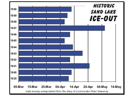
Historic Ice Out
We're fortunate on the Rideau to have a bit of a glimpse into the past through the 1839 to 1850 diary of the lockmaster at Jones Falls; Peter Sweeney. While Peter did not normally record actual ice-out data, the figures can be somewhat interpolated. An easy one would be 1848 where he notes on April 8 - "ice nearly gone" and notes on April 10 "came by canoe from Davis". So my pick for ice-out in 1848 is April 9. Other years proved more difficult - in 1844 the first reference is April 9 "ice getting bad" and then the next is April 17 when Sweeney notes "Mr. Burrows came by water in a skiff". So for 1844 I use the entirely unscientific method of simply splitting the difference, and picked ice out to be April 13. Most other years are similar in their inaccuracy. The earliest ice-out was early April (on about April 7) while the latest was on about May 6 in the very cold spring of 1847. The rather unscientific average for that 12 year period is April 14.
The Lake Partner Program
Due to budget cutbacks within the Ontario Ministry of the Environment (MOEE) the program is being redesigned to be more economical and efficient. The program operate with four phases.
- Lake Partner Program. Cottagers submit one sample from their lake as early in the year as possible for Total Phosphorus analyses and collect water clarity readings on a weekly basis for the summer season. In some areas an enhanced program is done in which cottagers are given six water sample bottles to submit for total phosphorus analyses. This is intended to give an idea of seasonal trends and annual means from which a general idea of water quality is determined.
- Lake Partner Special/MOEE monitoring. Under this program the MOEE selects from five to ten lakes for full scale water monitoring to assess general lake health. A crew samples the lake bi-weekly for water clarity, oxygen and temperature profiles from top to bottom, and water chemistry analyses for over 30 parameters such as nutrients, general water chemistry and metals. In addition samples for algae and zooplankton are collected for food chain health assessment and general deterioration. These sets are conducted on lakes undergoing remediation and in the Lake Partner Enhanced area.
For more information on the Lake Partner Program visit the Lake Partner Program Website
You Can Help
Anyone can help out with the Lake Partners Program. If your lake is not being done, contact your local cottagers association and have them register with FOCA. If you do not have a local cottagers association, then contact FOCA or the MOEE directly and volunteer to participate. They will send you a kit to get started. In the Rideau area, some lakes notable by the absence of water quality sampling include Clear, Cranberry and Lower Rideau.. If you are not sure if your lake is being done, contact MOEE and they will tell you. .
For more information contact:
Ministry of Environment and Energy
Lake Partners Program
P.O. Box 39
Bellwood Acres Road
Dorset ON P0A 1E0
Tel: (705) 766-2150
Toll Free: 1-800-470-8322
Fax: (705) 766-2254
email: lakepartner@ontario.ca
|
|
Federation of Ontario Cottagers' Association Inc.
156 Duncan Mill Road, Suite 18,
Toronto, Ontario, M3B 3N2
Tel: 416-429-0444
Fax: 416-429-4944
email: info@foca.on.ca
website: foca.on.ca/lake-partner-program-overview
|
Note: all comments and analysis of the data were done by Ken Watson and do not necessarily reflect the opinions or data interpretations of the Ontario Ministry of Environment and Energy.
 | |  |
Comments: send me email: Ken Watson
©1996- Ken W. Watson
|