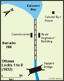
Ottawa - Locks 1 to 8
| location map | lockstation information |
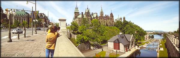 |
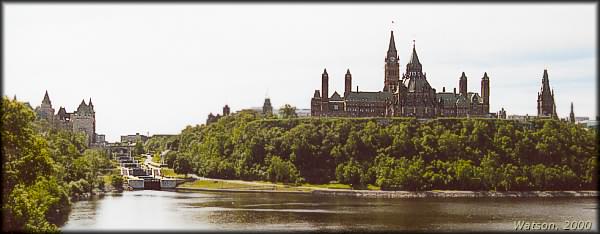
The Ottawa Locks - View from the Plaza Bridge
photo by: Ken Watson, 2000
Once the most dominant feature of Ottawa, most drivers passing over this bridge never notice the beautiful flight of eight locks. More than just an item of passing historic interest, these locks are the reason for the founding of Ottawa and represent an amazing engineering achievement in the middle of the Canadian frontier of the early 19th century.
Although motorists don't get a good view of the locks, the Plaza Bridge does provide pedestrians with an excellent view. Canada's Parliament buildings rise majestically in the background. The locks connect the channel of the Rideau Canal in Ottawa to the Ottawa River, almost 80 feet (24.4 m) below.
|
The Setting
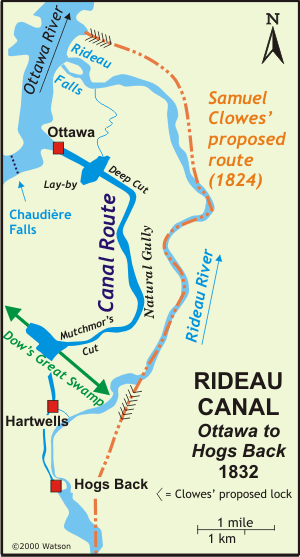
The problem here was how to get from the Ottawa River up to the Rideau River. The Rideau fell 30 feet (9.1 metres) in a set of twin falls, into the Ottawa River. The original algonquian name for the Rideau River is Pasapkedjiwanong, meaning the river that passes between the rocks. The word rideau is French for curtain, the appearance of the falls to Samuel de Champlain who travelled up the Ottawa River in 1613. The name Rivière du Rideau first appeared on maps in about 1694. Above the falls, the Rideau was composed of shallows and rapids for the first few miles (kilometres).
In 1826, when the canal was about to be built, the small community of Wright's Town existed on the north bank of the Ottawa River at Chaudière Falls. On the south side, below these falls, was Richmond Landing, the start of the land route to the new community of Richmond. A few settlers, such as Nicholas Sparks, Braddish Billings and Abraham Dow, were scattered about on the south side of the Ottawa River.
Samuel Clowes, who surveyed the entire Rideau route in 1823 and 1824, proposed to have the canal connect with the Ottawa a few hundred yards (metres) east (downstream) of the Rideau Falls. He proposed to do so through a series of six locks. Several miles (kilometres) of canal cuts and an additional seven locks were required to take the canal up to Black Rapids.
In mid-September 1826, Colonel By and a young engineer, Lieutenant Henry Pooley, together with several assistants, travelled to Wright's Town. By and Pooley spent several days on a "minute inspection of the various bays" near the mouth of the Rideau and "decided on the upper as best." The reason for this decision appears to have been in part due to By's view that the area from the upper bay to Hogs Back Rapids would be much easier to construct a canal through than Clowes' route, which traversed over several sections of hard rock. In 1826 it was much easier to excavate gravel and soil than it was to blast rock. Also, the chosen bay, then known as Sleigh Bay, was a much more defensible position than Clowes' chosen site. This reflected the difference between By's background as a military engineer and Clowes as a civil engineer. It is to be remembered that the main purpose of the Rideau Canal was the military defence of Canada.
On September 26, George Ramsay, the Earl of Dalhousie, Governor-in-Chief of Canada, and Lt. Colonel Durnford, commander of the Royal Engineers in Canada, arrived at Wright's Town and went over the ground with By, approving of what he had done. This was Dalhousie's favoured site. It's unknown whether By knew of this in advance and whether it had affected his decision. In June 1823, Dalhousie, on behalf of the government, had purchased 150 acres of land from Hugh Fraser, which covered the whole of the valley above Sleigh Bay, now referred to as Entrance Valley.
Dalhousie handed this land over to By stating, "I take this opportunity of meeting you here to place in your hands a Sketch Plan of several Lots of Lands, which I thought advantageous to purchase for the use of Government, when this Canal was spoken of, as likely to be carried into effect, this not only contains the site for the Head Locks, but they offer a valuable locality for a considerable Village or Town, for the lodging of Artificers and other necessary Essentials, in so great a Work. I would propose that these be correctly surveyed, laid out in lots of 2 or so Acres, to be granted according to the means of settlers and to pay a Government rent of 2/6 per acre annually." Several historians credit this with being the founding of Ottawa, since Colonel By acted on Dalhousie's advice and laid out lots, allowing settlement and the start of a vibrant community - Bytown.
The plateau at the top of Sleigh Bay stood 83 feet (25.3 m) above the low water mark on the Ottawa River. The ravine from the Ottawa River to this plateau extended over a distance of 1,090 feet (332 m). At the top, an area with limestone bedrock extended for 440 yards (402 m) to Beaver Meadow, a marshy area. The planned route of the canal then took it in a straight line for 1053 yards (963 m) until in intersected with a gully ("Natural Gully"). The line of the canal turned almost 90 degrees at this point and followed the gully for 3300 yards (3018 m) to its south exit. From the south exit of the gully, the line of the canal continued for 763 yards (698 m) to a spot called the "Notch of the Mountain", a break in an extensive low ridge, about 35 feet (10.7 m) in height, that crossed the route of the canal. This notch was located about 345 yards (315 m) from Dow's Great Swamp.
Dow’s Great Swamp originally extended from the Rideau River to the Ottawa River, a distance of about 4 miles (6.4 km). It averaged about 450 yards (412 m) wide, a relic flood channel. It was about one and half miles (2.4 km) from Dow’s Great Swamp to Hogs Back Falls.
It was another 783 yards (716 m) past Dow’s Great Swamp, along the line of the canal, to where Hartwells Locks would be constructed. It was about another 1550 yards (1417 m) to Hogs Back.
 Colonel By ordered his Chief Clerk of Works, John Mactaggart, to do a survey from Entrance Valley to an area of calm water above Hogs Back Rapids (originally known as Three Rock Rapids), called Captain Wilson's Still Water, named for Captain Andrew Wilson, R.N., who had settled there. In early November 1826, Mactaggart, with three survey assistants, three axemen and two men to carry provisions, set off to survey the route. Mactaggart had the axe men cut a line along which he took a flying survey (rough survey accurate to about +/- 1 foot (0.3 m)). Mactaggart noted that there were some differences between surveying in England and in Canada; "Taking a level of this extent in England would not have occupied more than a day; but in a dark dense wood, the subject is quite altered …. if we get upon a hill or other eminence in Britain, we may see the natural lead of the land; but in Canada, owing to the wilderness, you have to grope about like blind men." Mactaggart found that he could not complete his survey due to water-filled swamps, so he returned to the Ottawa River and waited until the region froze. On December 20 he set out again. Colonel By ordered his Chief Clerk of Works, John Mactaggart, to do a survey from Entrance Valley to an area of calm water above Hogs Back Rapids (originally known as Three Rock Rapids), called Captain Wilson's Still Water, named for Captain Andrew Wilson, R.N., who had settled there. In early November 1826, Mactaggart, with three survey assistants, three axemen and two men to carry provisions, set off to survey the route. Mactaggart had the axe men cut a line along which he took a flying survey (rough survey accurate to about +/- 1 foot (0.3 m)). Mactaggart noted that there were some differences between surveying in England and in Canada; "Taking a level of this extent in England would not have occupied more than a day; but in a dark dense wood, the subject is quite altered …. if we get upon a hill or other eminence in Britain, we may see the natural lead of the land; but in Canada, owing to the wilderness, you have to grope about like blind men." Mactaggart found that he could not complete his survey due to water-filled swamps, so he returned to the Ottawa River and waited until the region froze. On December 20 he set out again.
The surveying of the swamps in winter wasn't much easier than before, "we .. cut holes through the thickets of these dismal swamps, directed a person to go about half a mile before, and wind a horn, keeping to one place, until those behind came up so that by the compass and the sound, there being no sun, we might better grope out a course." Mactaggart also used another method developed by Canadian land surveyors. The staff man would proceed ahead on a compass bearing. At some distance, he would stop and light a candle in a lantern on the levelling staff. The surveyor would spot the candle through the sights on his theodolite and take a reading.
As a result of the survey, Mactaggart made several suggestions for how to carry the canal works to the still water at Captain Wilson's. The most novel suggestion was to build a wooden aqueduct on top of cedar tree stumps, "… an aqueduct of wood I propose. Instead, however, of supporting it on piles or arches, as is the case commonly, I propose that the head of cedar-trees, which grow as thickly in the swamp as they possibly can grow, and average fourteen inches thick, and seventy feet high, be sawn off to the proper level, in the route of the canal, so as to form props for the bottom sides, and towing-path. Upon this foundation, with clay, puddle, and planking, I consider there can be little difficulty in carrying the canal over, as shown in the drawing. A cedar-tree when cut down, will remain fresh fifty years; and surely, a tree standing on, and fixed by its roots is a stronger and steadier support for an aqueduct, than any pile …." Mactaggart also suggested that trees for 200 yards (180 m) on either side be cut down to prevent damage to the aqueduct in the case of forest fire.
It is also interesting to see that Mactaggart, in his report to Colonel By, noted that Lake Chaudière, above Chaudière Falls, was only thirteen feet (4 m) below the summit level of the proposed Rideau Canal. Mactaggart noted a junction could be made with the Rideau in Dow's Great Swamp, and that with two locks, and a canal cut of five miles (8 km) down the line of Dow's Great Swamp, the Rideau could be joined with the Upper Ottawa River, opening it up to easy navigation. Mactaggart's suggestion was not acted upon since Colonel By only had a mandate to create a navigation route between Kingston and the lower Ottawa River.
The Plans
It will be seen that the plans for this section of the route, as at most locks, changed during construction. This was engineering on the fly, works had to be adapted to the conditions By encountered. These included man-made problems such as survey errors, and problems with nature such as unexpected bedrock, vile smelling mud, spring floods, and malaria.
For the Ottawa Locks, at a place now known as Colonel By Valley or Entrance Valley, eight locks and a turning basin were proposed. These locks were of the originally approved smaller size, 108 feet (32.9 m) long by 20 feet (6.1 m) wide. The turning basin was to be positioned between locks 4 and 5.
Colonel By’s original plan was to run the canal as an excavated cut from the Beaver Meadow straight to the Notch of the Mountain. From there it would follow a route similar to the present course of the canal but intersect the Rideau River at the foot of Three Rock Rapids (at the foot of Peter's Gully – about 270 metres north (downstream) of the present Hogs Back dam). He then planned to follow a modified version of Samuel Clowes' proposal, to run a canal cut around Three Rock Rapids (Hogs Back), put three detached locks into Gloucester Snie (a flood channel that ran around the east side of Three Island Rapids) – bypassing Three Island Rapids (at the head of today's Mooneys Bay) and returning to the Rideau River in the still water above Three Island Rapids (a spot a few hundred metres south (upstream) of today's Mooneys Bay). He soon abandoned this plan, likely due to the difficulties in excavating canal cuts in bedrock and adopted the route we see today, intersecting the Rideau River at the head of Three Rock Rapids (Hogs Back).
In Beaver Meadow, a few hundred yards (metres) from the top of the first flight of locks, a lay-by (basin) was to be constructed with a waste water channel and weir (designed as a small lock with gate sluices in both sets of gates) built to drain off excess water, protecting the integrity of the locks in Entrance Valley.
To avoid excavation and take advantage of topography, he planned to excavate a cut from the Beaver Meadow to the Natural Gully, damming the outlet of the gully and then following the gully to the Notch of the Mountain. The gulley required little excavation, most of its length could be made navigable by flooding. A canal cut excavated through the Notch of the Mountain would bring the canal to Dow's Great Swamp.
Dow’s Great Swamp was to be traversed by a mounded aqueduct, a large mound of earth in the middle of which would be the channel for the canal. Another aqueduct was required to cross Peter’s Gully, and then the canal would arrive at Hogs Back where three locks were proposed to bring the canal up to the level of the Rideau River above the falls. A dam was be built there to flood the rapids above Hogs Back and to put water into the canal channel leading to the Ottawa Locks.
The Building of the Locks
 After deciding on the location of the entrance to the Rideau, Colonel By wasted no time in starting work. He was hampered by the fact that his total budget for 1826 was only supposed to be £5,000. Nevertheless, he hired contractors to clear the trees from the site of the proposed locks.
Tenders were released early in 1827 for the works. John Pennefather was awarded the contract in April 1827 to do the excavation work for the locks. Although Walter Fenlon was the lowest bidder on the masonry contract, the contract was awarded to the partnership of Thomas McKay and John Redpath. This was because of their experience with masonry work, both having worked on the Lachine Canal, and more recently, Thomas McKay's masonry work on the Chaudière Bridge, built under the direction of Colonel By in the winter of 1826/27. Walter Fenlon was awarded the contract for excavating the basin in Beaver Meadow and the construction of the drainage channel and waste weir. Philemon Wright (the founder of Hull) and Sons was awarded the contract for the mounded aqueduct through Dow's Great Swamp.
By the end of 1827, good progress had been made on the locks with excavation two thirds completed and portions of the first three locks completed. Material used for the locks was limestone, quarried on the cliffs on each side of Entrance Valley. In 1827, the partnership of Thomas McKay and John Redpath was awarded the contract to build the Commissariat building on the west side of the locks (now the Bytown Museum). A similar building, the Ordnance Building (Royal Engineer's Building) was built at the same time by Robert Drummond on the east side of the canal works.
In the spring of 1828, work was stopped while Colonel By waited to hear from the Kempt Committee whether his request for a larger lock size (to allow steamboat passage) would be accepted. In June, the committee decided that locks 134 feet (40.8 m) long by 33 feet (10.1 m) wide should be used.
The original masonry work done to that point had to be torn down, the contract for that work awarded to Thomas McKay. Since it still required eight locks to provide the required lift and each lock was now longer, the concept of a central turning basin had to be abandoned and all eight locks were built contiguous to each other, or, stated in canal terms, they were eight locks "in flight."
It was while excavating for the larger lock size that several springs in the rock and loose sand were encountered. Extra expense was incurred to pump water out of the works. Running sand in the third and fourth lock pits threatened the integrity of both the Engineers' building and the Commissariat. A dry wall had to be built to retain the sand and soil. Problems were also experienced in keeping water out of the lower lock as it was being built. Coffers dams had to be built and extensive pumping was required. The poor quality of the bedrock led to all eight locks being built on inverted masonry arches.
Some modifications were made to the locks as they were being built. By raised the height of the upper or eighth lock and its gates by two feet (0.6 m), "in order to lessen the great and heavy expense of taking out the last two feet of Excavation through the Deep Cut and Notch of the Mountain." The chamber walls of the river lock (No.1 lock) were raised to the height of the second lock to prevent flood waters from flowing over them. The sill for this lock was placed six feet (1.8 m) below the normal summer depth of water to allow for drought conditions. When the locks were completed they had a combined lift of 79 feet (24.1 m).
During the initial tests of the locks, water pressure actually moved several of the large stone sills. Bolts, straps and cement were then used to secure these in place.
In September 1831 the steamboat Union was the first vessel to pass through the Ottawa Locks.
Other Works
The very impressive Sappers Bridge, made entirely of stone, with a road width of 18 feet (5.5 m) and a clearance of 28 feet (6.4 m) over the canal, was built at the same time as the locks. It connected Upper and Lower Bytown, and for the first half the century it was the only bridge crossing the canal below Burritts Rapids.
Colonel By built himself a house, overlooking the Ottawa River, on Major's Hill. Lt. Pooley built his house close by to Colonel By's. On Barrack Hill, now called Parliament Hill, By had 3 stone barracks and a hospital constructed. Just a little bit downstream of the locks, on the Ottawa, a wharf and a depot were built.
On the plateau above the locks, where the canal left the hard limestone and entered Beaver Meadow, By had a basin (lay-by) constructed. The contract for the area from the head of the locks to Dow’s Great Swamp was given to Walter Fenlon. The basin was to provide dockage for boats and be a reservoir for the locks. A weir and waste water channel was constructed to prevent the flooding of the locks, providing an outlet for excess water. That weir had a unique design; it was built as a small lock with gate sluices to regulate the water flow. In June of 1828 Walter Fenlon, who was also doing the dam at Hogs Back, asked to be released from his contracts as he was losing money. Philemon Wright and Sons took over the work. Philemon Wright wasn't involved, it was his sons Ruggles and Tiberius who did the Rideau Canal contracted work.
Once the area between the Ottawa Locks and Hogs Back had been completely investigated, By realized that he could apply his slackwater system in this area. About a 1,050 yards (960 m) southeast of the Beaver Meadow was a gully known as the Natural Gully. By had a cut, known as the Deep Cut, excavated directly to that gully. At the point of intersection he had the gully blocked with a dam, 15 feet (4.6 m) high by 315 feet (96 m) long, in order to flood it. The canal then followed the gully for 3,300 yards (3 km) to the Notch of the Mountain, a low point in a ridge that crossed the line of the canal. He had a cut ("Mutchmor's Cut") excavated through the Notch of Mountain, bringing the canal to Dow's Great Swamp.
At Dow's Great Swamp, Philemon Wright and Sons (Ruggles and Tiberius Wright) had been contracted to build a mound across the swamp for the purposes of an aqueduct. It was noticed early on that the embankment that was being created was watertight. In 1828, By stated that with the embankment being watertight it could turn, "that unhealthy swamp into a fine sheet of water and does away with the original idea of forming an aqueduct in the centre of the said mound." In order to create that fine sheet of water, another embankment was required on the "downstream" side of Dow's Great Swamp.
The reason that Dows Lake exists as it does today, is that the second embankment (built by Jean-Baptiste St. Louis) was placed some 880 yards (804 m) further into the swamp (northwest), where high banks bounded the swamp, a location known as the Ridge of the Swamp. This allowed for a much shorter embankment to reach from one bank to the other. As one of the Royal Engineers, Lt. Frome, succinctly put it: "Dow's Great Swamp, which, by means of two massive earth embankments, is converted into a pool 20 feet deep."
It was originally intended to take the canal cut as far as Hogs Back, where three locks would lift the canal to the height of the Rideau River. However, detailed surveys showed that the land rose after Dow’s Great Swamp and so, to save extensive excavation, By moved two of the three locks he planned for Hogs Back to Hartwells, just a few hundred yards (metres) from the edge of Dow’s Great Swamp.
By’s use of the slackwater system in Ottawa meant that only 62% of this section was excavated with 38% done by flooding natural features. In the end, of the 5.2 mile (8.4 kilometre) total distance from the Ottawa River to where the canal joined with the Rideau River at Hogs Back, some 3.1 miles (5.2 km) was done with excavated canal cuts, 1.9 miles (3 km) was done by flooding the Natural Gully and 0.2 miles (0.35 km) was done by flooding a portion of Dow's Swamp.
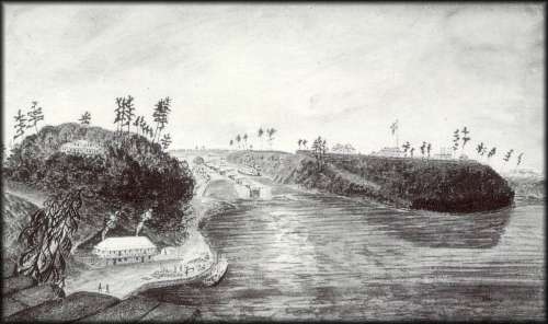 |
First Eight Locks of the Rideau Canal, the North Entrance from the Ottawa River, 1834
Thomas Burrowes, Watercolour, Archives of Ontario
A view of the eight locks in Entrance Valley. The Commissariat Building and the Royal Engineers Building (Ordnance Building) sit on either side of the locks. The Depot is in the foreground of the picture, with Colonel By’s house on the hill behind it. On the far hill, Barrack Hill (now Parliament Hill), sit three stone barracks and a hospital.
|
 |
The Ottawa Locks
photo by: Ken Watson, 2000
Although the locks haven't changed from Burrowes' day, they are now dwarfed by the Chateau Laurier Hotel on the left and Canada's Parliament Buildings on the right.
|
Through the Years
There were no major repairs on the locks until the late 1800s. Several of the stone blocks had to be replaced by sandstone from the government quarry in Elgin. As with all the locks, the wooden lock gates had to be replaced every 20 years or so. In the 1920s, solid concrete blocks were used to replace the stone facing in locks 3 through 7. Major reconstruction of the locks was done in the late 20th century. In 1986, locks 1 to 3 were rebuilt, in 1988, locks 4 and 5 were rebuilt and in 1993, locks 6 to 8 were reconstructed. Original facing stones were preserved in locks 6 to 8. For the other locks, in order to make the locks appear authentic, stone was hauled from the Bruce Peninsula, cut at St. Catharines, and then bush hammered and etched onsite to give the appearance of the original work done by a stonemason.
Major changes have taken place on the canal as it passes through Ottawa. Changes were made to the lay-by starting in the 1870s when the east side of the basin was removed to make way for railroads. In the 1920s, the west portion was starting to be filled in for development, and by 1927 the entire area had been filled in.
The Royal Engineers’ Building on the east side of the lock was converted into a private residence in 1868. In 1901, the rail line from Ottawa to Hull, by way of the Interprovincial Bridge, was built with the railroad terrace actually going through a portion of this old building. Vibrations from passing trains caused extensive damage to the building and it was torn down in 1911-12. The foundations of this building can still be seen next to the locks.
In 1832, after Colonel By returned to England, the new Superintending Engineer of the Rideau, Captain Daniel Bolton (promoted to Major in 1838) took up residence in Colonel By’s house located in what is now known as Major's Hill Park (named after Major Bolton). The house burned to the ground on October 5, 1848. It was never rebuilt. Today you can see the excavated foundation and interpretive panels for the house.
The old Sappers Bridge was taken down in 1912. A testimony to the quality of its construction was that initial attempts at blasting failed to damage the bridge, and it had to be brought down by repeatedly dropping a large weight onto the bridgeworks.
A defensible lockmaster’s house was built in 1849 but it was torn down in 1875 when Major's Hill Park was created. The Chateau Laurier Hotel now sits on the former site of this house.
The stone building that stands at the head of the locks was built in 1884 for use as offices for the lockmaster and the toll collector.
Bytown was incorporated as a town on January 1, 1850, then officially renamed as Ottawa in 1855 and chosen as the site of Canada’s Parliament. In 1859 the buildings on Barrack Hill were removed to make way for the construction of the new parliament buildings. Barrack Hill is now known as Parliament Hill.
The canal through Ottawa has seen many other changes over the years. The railway yards along the side of the canal have been removed, scenic drives and bicycle paths have been established, and thousands of tulips, given to Canada by the Netherlands, have been planted in gardens around Dows Lake and beside the canal. In downtown, several new buildings, such as the National Arts Centre, now look over the historic Rideau Canal.
The Lockmasters to 2000
The first lockmaster was William Addison (a sergeant in the 7th Company of the Royal Sappers and Miners), appointed at the opening of the canal and retired in 1871. He was succeeded by his son William G. Addison who died Jan 1890. N.W. Clarke, who had been a labourer at both Davis and Jones Falls, served as lockmaster from 1890 until he died in 1907; W.H. Bishop served as lockmaster until April 1921. John Balchin served as lockmaster from 1922 to 1947; followed by R.J. Little from 1948 to 1961; George Gravelle from 1962 to 1972; Aldage Brisbois from 1973 to 1974; unknown from 1975 to 1979; Gord Giffin from 1980 to 1981; Joe Ducharme as acting lockmaster in 1982. The locks were closed for repairs in 1983 and when re-opened Marcel Belanger served as lockmaster from 1984 to 1985 followed by acting lockmaster Al Berger (lockmaster for Hogs Back) who served sporatically until 1999 (with other acting lockmasters) until Marc Beaudry was appointed acting lockmaster in 1999.
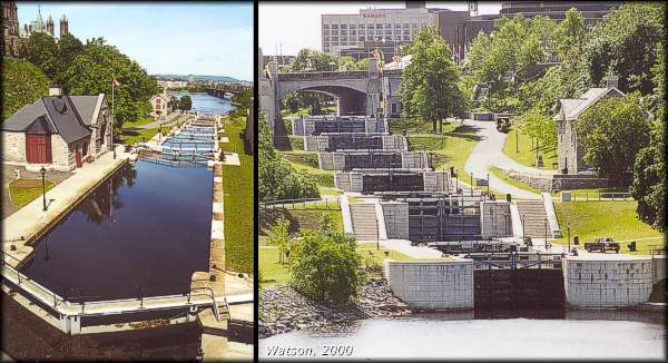 |
The Ottawa Locks - looking west (left) and looking east (right)
photos by: Ken Watson, 2000
In the west (left) view, the beautiful stone lockstation building can be seen, and farther down on the left side is the former Commissariat, now the Bytown Museum (well worth a visit). In the distance is the Alexandra Bridge leading to Hull. Formerly the Interprovincial Bridge, it carried rail traffic across the Ottawa River. Today it is busy with vehicles, bicycles and pedestrians.
In the east (right) view, the Commissariat building is visible as is the Plaza Bridge at the head of the locks. Even though the locks are in the middle of a major urban centre, they manage to maintain the tranquil beauty and charm that characterizes a typical Rideau lockstation.
|
|