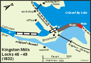
Kingston Mills Locks 46-49 | location map | lockstation information |
The Setting
At Kingston Mills, the Cataraqui River fell about 17 to 20 feet (5.2 to 6.1 m) over a series of rocky falls (Cataraqui Falls), for a distance of about 600 feet (183 m). High rocky cliffs bounded the Cataraqui as it descended to the level of Lake Ontario. Below Kingston Mills, the Cataraqui wound its way through swamps and marshes until it emptied into Lake Ontario at Kingston Bay.
In 1784, the British Government built a saw mill and a grist mill at this location, the first fall of water up the Cataraqui River, in order to help the new settlers in the fledgling Loyalist settlement of Kingston. By 1826, the grist mill (the second in this location) had gone out of use but a saw mill (the third in this location) was still operating.
The Plan
The plan submitted by Samuel Clowes to the Macauley Committee in 1824 was to bypass Kingston Mills with an artificial canal cut to the west of the Cataraqui River. It was to exit the Cataraqui just above Kingston Mills and then descend through four locks to the level of the Cataraqui below Kingston Mills, rejoining the original course of the river about a mile and half (2.4 km) downstream of the mills.
The proposal made just prior to construction was to place three locks in flight, each with a lift of 9 feet, 4 inches (2.8 m), right at Kingston Mills. A 10 foot (3.0 m) dam was to be placed across the main channel of the Cataraqui, near the head of the locks by the old mill bridge, where the depth of water was 8 feet (2.4 m). This dam would raise an additional 2 feet (0.6 m) of water all the way up to Jack’s Rifts.
By 1828, plans had changed. In June 1828, the Kempt Committee approved locks 134 feet long by 33 feet wide (41 m x 10 m) to allow for steamboat navigation, an increase in size from the original proposal of locks 108 feet by 20 feet (33 m x 6 m). Colonel By was faced with two significant problems. The larger locks would entail much more rock work than originally anticipated at Kingston Mills. In addition, since the Rideau was now to be used for steamboat navigation, vessels larger and less manoeuvrable than originally intended, a straighter channel was required between Kingston Mills and Lower Brewers. By was not looking forward to having to excavate any more than he had to through these malaria infested swamplands.
So, By, as he had done at other lockstations, decided to adopt a bold new plan. He proposed to raise the dam at Kingston Mills by 20 feet (6.1 m), to 30 feet in height (9.1 m), and add a fourth lock so that the total lift here would be 46 feet, 8 inches (14.8 m). This would not only improve navigation through the swamps, it would also do away with the need to place locks at Jack’s Rifts and Billidore’s Rifts located between Kingston Mills and Lower Brewers Mills. Because of the topography at Kingston Mills, the fourth lock had to be detached, and a turning basin was to be placed in between the upper lock and the lower flight of three locks. To quote By; " … my proposal to do away with the Locks at Billidores & Jacks Rifts by placing a fourth Lock at Kingston Mills, raising the Dam at that place, and forming certain embankments to retain the water, so as to convert Catraque Creek into a fine sheet of water, extending to the high land on each side and thereby drowning that pernicious swamp, by forming it into a small Lake …"
The dam would be placed at the head of the main channel of the Cataraqui, with the locks to be built in a side channel to the west of the main channel. On either side of the dam, long earthen embankments with a clay core would be built to retain the water raised by the dam. A waste weir would be placed in the dam to control water levels.
Building the Locks
The initial clearing of the site in early 1827 was done by a Mr. McDermott. The contract for the construction of the locks and dam was awarded to Robert Drummond.
Malaria was a significant problem at Kingston Mills. It hit hard in the summer of 1828. In September 1828, Captain Savage wrote, "… At Kingston Mills, Lieut. Briscoe Roy Engr, the asst. Overseer, the Contractor, his Clerk, Foreman, and nearly the whole of his men (about 100) have been attacked, the Clerk and 12 men have died, Lieut. Briscoe still continues extremely ill, with the lake fever. …"
 The locks, situated in a side channel, could be constructed "in the dry." A coffer dam had been built in front of the lower lock, to keep the Cataraqui River at bay. Drummond positioned his new steamship, The Pumper, beside the coffer dam and used its 12 horsepower steam engine operated pumps to keep the lower lock free of water. The locks, situated in a side channel, could be constructed "in the dry." A coffer dam had been built in front of the lower lock, to keep the Cataraqui River at bay. Drummond positioned his new steamship, The Pumper, beside the coffer dam and used its 12 horsepower steam engine operated pumps to keep the lower lock free of water.
The dam was constructed with stone key work at the back and a sloping apron of earth, stone and clay in the front. The key work was large blocks of stone laid on end, to form a dam in the shape of an arch in order to hold back the pressure of the water (an arch throws the weight put against it onto the end footings). Behind this stone was placed an impervious layer of clay puddle - clay, gravel and sand mixed and beaten together to form a watertight barrier. On top of this, "rubbish" material - earth, clay, gravel and rock, formed a gently sloping front. At Kingston Mills, this front had a very gradual slope and was much larger than originally intended.
The dam was about 400 feet (122 m) long, with a masonry weir placed in the east side to control the level of the water above the dam. Extending east (from the weir) was an earthen embankment, about 1000 yards (915 m) long, extending all the way to banks that were high enough to contain the raised water. On the west side, the dam arched to meet bedrock lying beside the upper wing wall of the upper lock. On the other side of the lock another earthen embankment, also about 1,000 yards (915 m) long, was built to contain the water to be raised by the dam.
The basin between the detached lock and the lower flight of three locks was constructed with a dry dock built into it for steamship repair. The upper side of this basin was the embankment that extended out from the west side of the lock. The basin side of this embankment was faced with stone. The lay-by (dry dock) was about 130 feet (40 m) long. Piers were placed at its entrance so that gates could be hung to allow the lay-by to be pumped out if necessary. In the winter, the basin would be drained, leaving this lay-by dry (hence "dry dock").
The lower three locks were constructed so as to be "in flight" (contiguous). They were designed so that eight feet (2.4 m) of water would be over the lower sill of the lower lock, to allow for seasonal fluctuations in the water level of Lake Ontario. The bottom lock was built with a wooden floor, the other three locks had bare bedrock floors.
A roadway ran along the west embankment leading to a drawbridge that was placed over the upper lock. The road continued onto a timber bridge across the Cataraqui River below the arch stone dam. This was to connect to the Montreal to Kingston road, the main land route at the time.
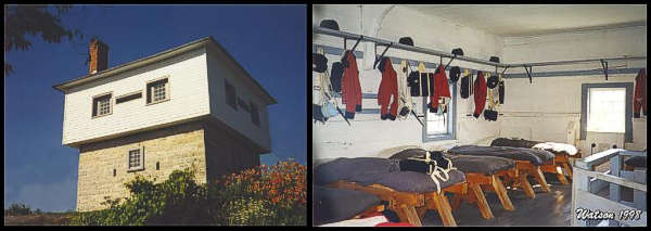 |
Blockhouse at Kingston Mills
photos by: Ken Watson, 1998
The Blockhouse still stands guard over the locks. Inside the beds are made, the uniforms neatly hung. |
In 1832 the construction of a blockhouse was started, one of only four built along the Rideau. It was completed in about 1834. It was built to the same dimensions as those at Narrows and Newboro, 24 feet (7.3 m) on a side, designed to accommodate 20 men. It was built with a masonry base, about 3 feet (0.9 m) in thickness, with an upper storey, 28 feet (8.5 m) on a side, built of large squared timbers. Access was by a stairway to the second floor.
A wood framed house was built in about 1828 by Robert Drummond for his use during the construction period. It was located several hundred yards from the works on the west bank of the Cataraqui above the upper lock. After construction it was used as the lockmaster's house.
The construction activity, easy road access, and proximity to Kingston led to a fairly large community being developed at this site. A census taken in November, 1830, showed 101 buildings, including 3 licensed taverns, a Catholic chapel and a schoolhouse.
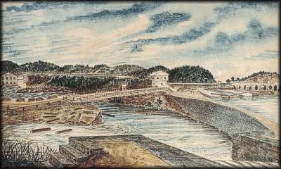 |
Kingston Mills; post-1856
Thomas Burrowes, watercolour, Archives of Ontario
This painting shows the waste weir in the right foreground. From the weir, a cut stone dam leads to the bedrock on which the blockhouse is built. The upper lock sits to the right of the blockhouse. A long bridge crosses the original channel of the Cataraqui River, part of the Montreal-Kingston road, and a drawbridge takes the road over the upper lock. |
Through the Years
The locks underwent mostly normal maintenance for the first 50 years. In 1872 the area around the lower sill of the bottom lock collapsed and had to be repaired. It had been built on clay, with a foundation of timber and planking. Water had eroded below the sill, causing the collapse. In 2018-2021 the locks underwent extensive restoration work.
In 1902 the masonry waste weir in the stone dam was entirely reconstructed. In 1909, the 220 foot (67 m) wooden bridge across the river below the dam was replaced by a 100 foot (30.5 m) steel bridge. An earth embankment was put in to make up the difference in length. This fixed bridge was replaced during the fall/winter of 2016/17.
The original bridge across the upper lock was a double leaf timber drawbridge built in 1831. It was replaced some time later by a wooden swing bridge (easier to use than a drawbridge). In 1956 a steel through plate girder swing bridge was installed. That bridge was replaced by another steel swing bridge in 1988. That bridge was rehabilitation in the fall/winter of 2016-17.
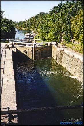 |
Lower Locks at Kingston Mills
photo by: Ken Watson, 1999
Looking from the middle lock in the lower flight of three locks to the Cataraqui River channel leading to Lake Ontario, below. |
The blockhouse housed militia stationed at Kingston Mills in the winter of 1837-38. In the late 1800s a wooden framed wing was added to the blockhouse to make it more liveable. This wing was enlarged in 1909. It was removed during renovations in the 1960s to restore the original military characteristics of the blockhouse.
The lockmaster originally stayed in a wooden frame house built for Robert Drummond during the construction of the canal. By 1860, this building had badly deteriorated and a new building was constructed. However the new building was of very shoddy construction and in 1904 it was replaced by the large wooden house now situated on the west side of the locks (now the Anglin Visitor Centre).
In 1853 the Grand Trunk Railroad built a wooden truss bridge over the lower locks. It was replaced at least once (c.1890) and the current steel bridge (CNR) was built in 1929.
The site saw a successive series of sawmills (four) and grist mills (three) adjacent to Cataraqui Falls. The sawmills were located on the east side of the falls with the original grist mills on the west side. The last (4th) sawmill was built in 1848. It was demolished in 1863 and was replaced by a stone grist mill. That grist mill was badly damaged in the spring freshet of 1905. The remains were demolished in 1913.
In 1913, major changes were made to the lock site when a hydroelectric powerhouse was built below the waste weir. At this time, the grist mill was removed, and a new dam and waste weir constructed a short way downstream of the existing dam and weir, with a sluiceway leading to the generating station.
The extensive berms on either side of the locks were rehabilitated in 2004.
The Lockmasters to 2000
Colonel By's recommendation was George Hay, a corporal in the 7th Company, Royal Sappers and Miners. It is unclear if he actually served in this position. If he did, he was soon replaced by John Brady, who was shown as having served for 13 years in 1845. Brady retired in 1857 and was replaced by William Robinson who remained until his death in 1867. A lock labourer, Joseph Deane, replaced Robinson and served until he died in 1892. Robert Anglin succeeded him. Anglin was dismissed for political reasons in December 1896, but was reinstated in spring 1897 and served at the station until his retirement in 1919. He was followed by William Burton from 1919 to 1924; J. Earl Doyle from 1925 to 1958; Richard J. Barrett from 1958 to 1961; William T. Aurey from 1962 to 1970; J. Albert Mills from 1971 to 1979; Francis M. Corrigan from 1980 to 1986; David Blair, acting from 1985 to 1986; Raymond G. Bryan from 1988 to 1998 (he was disability for part of this time, acting were Claude Langevin for part of 1992; Jim Higginson for part of one season; and Bob Martin for part of 1996); Herb Simpson, acting for 1998 to 1999 and lockmaster in 2000.
For more information about Robert Anglin see the Anglin Family Story
|