Nicholsons Locks 18-19
| location map | Lower Nicholsons lock info | Upper Nicholsons lock info |
The Setting
Nicholson's Rapids were 990 yards (905 m) in length, descending in that distance 14 feet 5 inches (4.4 m), with a depth over the proposed dam site of 1 foot 9 inches (0.5 m). The rapids were named for one of the first settlers in the area, Robert Nicholson, who served with Jessup's Corps in the American Revolution. He may have been influenced to come here by the fact that another member of Jessup's Corps, Lt. Gershom French, had surveyed the Rideau in 1783 and had reported the area favourable for settlement.
The Plan
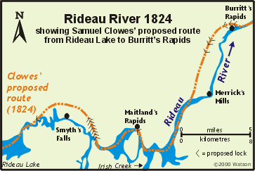 Samuel Clowes' plan put forward in his 1824 report was to bypass the entire section of the Rideau River between Burritt's Rapids and Merrick's Mills (including Nicholsons) with a canal cut on the west side of the Rideau River. Six locks were proposed at the Burritts Rapids end to lift the canal the required elevation (about 55 feet - 17 m). Samuel Clowes' plan put forward in his 1824 report was to bypass the entire section of the Rideau River between Burritt's Rapids and Merrick's Mills (including Nicholsons) with a canal cut on the west side of the Rideau River. Six locks were proposed at the Burritts Rapids end to lift the canal the required elevation (about 55 feet - 17 m).
By's plan was to stay in the channel of the river. The tender for the work at Nicholson's stated: "To construct a Dam, Lock and Embankments at Nicholson's Rapids. The dam to be raised 16 feet high and 250 feet wide; the Lock 10 feet lift; and the embankment eight feet high, and 280 feet long." This original plan would have placed the dam at the foot of the rapids, raising the water to flood the rapids, with a single lock to bring vessels up to the new water level formed by the dam. However, this plan had to be modified.
By found out during the re-survey of the site, that Clowes' original survey was in error, that the rise to be overcome was greater than originally surveyed, and that the banks of the river in this area were lower than originally indicated, meaning that if the dam had been placed where proposed, it would have flooded a large area of tillable land. By noted, "The levels from which the original Estimate was formed proved, upon a more minute examination of the ground, very erroneous, the rise to be overcome being above fifteen feet 2 inches, and the necessary height of Dam Twenty feet, 2 inches, the nature and extent of the Embankments required were also much underrated, and if the Dam had been placed on the Site at first proposed, a much greater extent of cultivated land would have been flooded than provide for, the value of which much necessarily have occasioned a considerable increase in the Estimate."
By further stated, "I deemed it indispensably necessary to deviate from the original plan, and instead of keeping [to] the river, and raising the whole lift by a single Lock, placed in connection with the Dam, I have quitted the same at the foot of the Rapids, cutting the Canal along the right Bank, placing Two Locks in the above distance, to suit the section of the ground, and forming the Dam at the head of the Rapids."
So, the new plan was similar to that of Burritts Rapids, placing the dam at the head of the rapids, and bypassing the rapids with an artificial canal cut.
Building the Locks
The contractor was A.C. Stevens and Co. Some reports show H.C. Stevens and Co. A.C. or H.C. Stevens remains a Rideau mystery since, even though he was a major Rideau contractor (Nicholsons and Merrickville), there has yet to be any historical information found about him (including his first name).
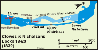 Work on the cut and two locks was slow going since the banks leaked water which had to be continuously pumped out to allow the work to proceed. It was also noted when building the dam, originally intended to be an overflow dam, that the bedrock was not strong enough to take the pounding from the fall of water that would have resulted. By decided that he would have to add a waste weir: "The rock forming the Bed of the River has also proved so unsound, that the construction of a Waste Weir has been deemed advisable." Work on the cut and two locks was slow going since the banks leaked water which had to be continuously pumped out to allow the work to proceed. It was also noted when building the dam, originally intended to be an overflow dam, that the bedrock was not strong enough to take the pounding from the fall of water that would have resulted. By decided that he would have to add a waste weir: "The rock forming the Bed of the River has also proved so unsound, that the construction of a Waste Weir has been deemed advisable."
By, explaining his increased expenses in the 1831 report stated: "The above statement will I trust satisfactorily shew, (an error having occurred, owing to the thickness of the woods and swamps,) that there was an indispensable necessity of deviating from the original plan and that the mode adopted is the most judicious one that could have been followed under the existing circumstances."
Much of the stone for the construction of the locks and dam came from Clowes' Quarry. The floors of the locks were left as bare bedrock. The completed locks had a combined lift of 14 feet, 10 inches (4.5 m).
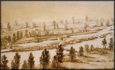 |
Nicholson's Rapids; ca. 1840s
John Burrows, watercolour over pencil, Archives of Ontario
This painting shows the two locks in the canal cut. Near the head of the cut is the waste weir leading to the original channel of the Rideau River. A defensible lockmaster’s house is situated on the knoll above the locks. The bridge across the river was used to bring stone from Clowes’ Quarry to the locks during construction. |
Through the Years
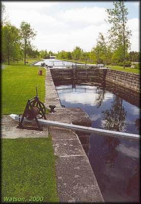 |
Lower Nicholsons Lock
photo by: Ken Watson, 2000
Looking south from the lower lock to the artificial canal cut. The white object in the far background is the swing bridge at the Upper Nicholsons lock. |
In 1838, a small (27 feet x 27 feet - 8 m x 8 m) non-defensible (no loopholes) stone lockmaster's house was constructed. It was noted in 1914 that this building was very cold and damp because like most of the lockmaster's houses erected along the Rideau, plaster had been laid directly on the stone walls. Sometime between 1914 and 1930 a second framed storey was added.
The locks were subject to normal maintenance. In 1910, the upper wing walls, upper sill and gate recesses of the upper lock were rebuilt in new stone and in 1912 the upper wing wall, piers and sill of the lower lock were also reconstructed.
The stonework of the waste weir was redone in 1907, a concrete facing was applied to the upstream face in 1913, and a concrete apron added in 1975-76.
The biggest problem over the years was the artificial cut between Upper and Lower Nicholsons. The bank on this cut leaked water. The wall along the bank, which had been done with dry stone sometime before 1867, was redone using cement in 1910-1913.
In 1851 there were nine buildings on the site; a one storey frame house occupied by the permanent labourer, a vacant frame house, an old stone house also vacant, a wooden storehouse in which both Ordnance stores and the temporary labourer were housed, a vacant log house, a stable, a small wash house, and a log cookhouse.
The former village of Andrewsville, on the west bank of the river across from Upper Nicholsons Lock, was established in about 1861 when Rufus Andrews built a grist (flour) mill, a sawmill and a shingle mill at this site. The grist mill was demolished in 1917 and the saw mill was destroyed by flooding in 1930. The concrete piers of the mill dam are still visible in the channel of the Rideau River today.
The first bridges in this area were built by Rufus Andrews in 1864; a timber fixed bridge across the Rideau River and a timber swing bridge across the lock. The swing bridge across the lock was replaced in 1877 by an unequal arm, center bearing timber swing bridge (of the same design that can be seen today at the lockstation). The timber fixed bridge across the Rideau River was replaced c.1900 by a steel through truss bridge.
The Lockmasters to 2000
The first lockmaster was Richard Frayne, a master mason recommended by By. He resigned in 1836 and was replaced by Thomas Jenkins of the Royal Sappers and Miners. Jenkins died suddenly in 1847 and was replaced by John Newman of Burritts Rapids who retired in 1871. He was succeeded by his son, William Newman, who served until retirement in 1907. His replacement was George E. Johnston, who was discharged in 1912, likely for reasons of patronage. Luke Depencier of Burritts Rapids succeeded him. Depencier retired in 1924. He was followed by George L. Davis from 1924 to 1933; Clarence Watt from 1934 to 1962; Leonard Hassall from 1963 to 1973; Charles Action from 1973 to 1976; Clarence Curry from 1977 to 1978; Ken Bygrove from 1978 to 1982 (from 1980 to 1980 Nicholsons joined with Clowes under one lockmaster); Ed Dale from 1983 to 1984; Peter Donnelly from 1984 to 1987; Charlie Sampson in 1988; Griff Cain in 1989; and Ron Welch from 1990 to 1997. In 1998 Nicholsons was again combined under a single lockmaster with Clowes and Gerald Covell was lockmaster from 1998 to 2000.
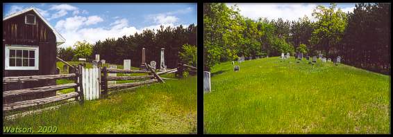 |
McGuigan Cemetery
photo by: Ken Watson, 2000
This cemetery, restored by the Merrickville and District Historical Society, is located at 448 River Road, directly across the river from Clowes Lock, about 0.8 km south on River Road from Upper Nicholsons lockstation. The earliest known grave is that of Samuel McCrea who died on November 15, 1806. The cemetery operated until about 1892.
There are two bronze plaques which read as follows:
McGUIGAN CEMETERY
This cemetery is one of the oldest burying grounds not only along the Rideau River but in Eastern Ontario. It was used for approximately one hundred years between 1800 and 1900. Unfortunately, there are few written records anywhere either as to its existence or as to who was buried within its confines. The tombstones discovered during its restoration in 1979 and 1980 by the Merrickville and District Historical Society tell only a small part of the role it played in the history of the area.
It was named after Miles McGuigan, an Irishman who served in the Peninsular War under Wellington in the 81st Regiment and who was later wounded at Waterloo. As an army pensioner after the War of 1812 he married the widow Leahy, who owned the land, a Crown Grant, on which the cemetery is located. Legend has it that he was buried here but his grave has never been found. The oldest known grave is that of Samuel McCrae, one of the earliest pioneers of the Lower Rideau Settlement.
IN REMEMBRANCE
This memorial marks the area where an unknown number of persons were buried in this cemetery between the years 1800 and 1900. Despite the scarcity of records, it is believed that many died of pestilence, principally malaria, during the construction of the Rideau Canal. From 1826 to 1832, they were mostly Irish labourers and the children of pioneer settlers. Their graves were marked only by simple fieldstones, some of which remain visible.
May They Rest In Peace.
Note: the canal era graves were originally marked with wooden markers which have long since rotted away. This has led to the erroneous impression that the graves were unmarked or marked only by fieldstones (which were generally used as footstones).
|
|