rideau-info.com
Celebrating all aspects of the Rideau Canal World Heritage Site
Rideau Waterway Title

Edmunds 
Lock 25 

Your location: Rideau Region > Rideau Waterway Home > Rideau Lockstations > Edmunds Lock 25

(history)  EDMUNDS Lock 25  (water map)  (road map)
Number of locks: 1 Total Lift: 2.8m ( 9 ft.) Lock Through Time: 15 min.*
Chart No: 1512 (Sheet 3) GPS:1 N 44o 52.650'    W 75o 59.015'
Chart Sales: No Lockstation Tel: (613) 283-4406
Washrooms: Yes2 Drinking Water: Yes3 Day Use Docking: No
Overnight Mooring: Yes Docking4 Upstream: 49m/160' Docking4 Downstream: 53m/175'
Ice: No Power: No Boater Camping:5 Yes
Boat Launch: Yes Picnic Tables: Yes BBQ Grills: No
Parking: Yes Public Telephone: No Self Guided Trail: No
Hwy Access: just N of Cty Rd. 17 
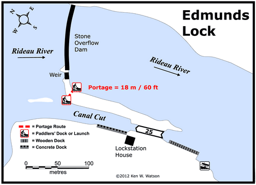
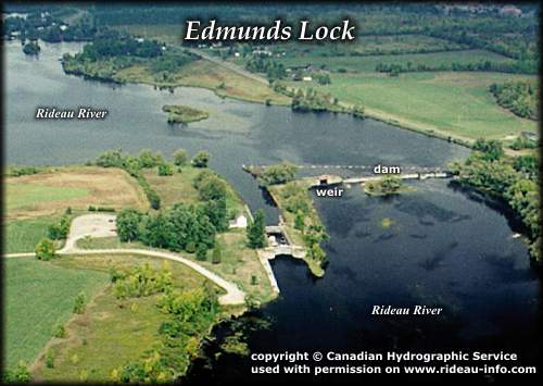
Lock Connects: Rideau River to Rideau River
Special Notes: To ensure passage, boaters must arrive at least 30 minutes prior to closing.
Of Interest: Edmunds features one of the few overflow dams on the Rideau system. A combination arch stone overflow dam and weir, the dam keep the water level at navigation depth while the weir provides an outlet for excess water, especially during spring runoff. A pretty white clapboard lockstation house and large verdant grounds mark the peaceful rural setting of Edmonds.
Notes: There are no nearby facilities (nearest gas is at Aylings, Merrickville).
* Time to actually go through the locks. Allow at least twice this time when trip planning. See Schedule Caveats.
1) GPS data should not be used for navigation. See the GPS page.
2) washrooms are wheel chair accessible.
3) Check with lockstation staff for potability of water.
4) Includes both blueline and greyline docking - see Lockstation Docking Page.
5) Allows tent camping for those arriving by water and also for cyclists and hikers.


Edmunds Lock
Edmunds Lock looking Northwest
A quiet solitude lock. Edmunds exhibits a feature of a few of the northern locks of an overflow dam in addition to the weir. The overflow dam provides general water level control with the weir used to drop water levels prior to and during spring flood.
photo copyright © Canadian Hydrographic Service - used with permission

Home ButtonTake Me Home!previous or next lockstation
previous arrownext arrow
Next Page ButtonLockstation Page

view the history of this lockstation
EmailComments: send me email: Ken Watson
URL: www.rideau-info.com/canal/locks/25-edmonds.html
© 1999-2008 Ken W. Watson