Your location: Rideau Canal Home Page > Rideau Lockstations > Kilmarnock Lock 24
| Number of locks: 1 |
Total Lift: 0.6m ( 2 ft.) |
Lock Through Time: 15 min.* |
| Chart No: 1512 (Sheet 3) |
GPS:1 N 44° 53.075' W 75° 55.825' |
| Chart Sales: No |
Lockstation Tel: 613-283-3792 |
| Washrooms: Yes2 |
Drinking Water: Yes3 |
Day Use Docking: Yes |
| Overnight Mooring: Yes |
Docking4 Upstream: 90m/295' |
Docking4 Downstream: 27m/90' |
| Ice: No |
Power: 5 Yes |
Boater Camping:6 Yes |
| Boat Launch: No |
Picnic Tables: Yes |
BBQ Grills: No |
| Parking: Yes |
Public Telephone: No |
Self Guided Trail: No |
| Hwy Access: ~ 1km S of Hwy 43 |
Lock Connects: Rideau River to Rideau River |
| Civic Address: 1424 Kilmarnock Road, Montague, Ontario |
| Special Notes: To ensure passage, boaters must arrive at least 30 minutes prior to closing. Swing bridge with a clearance of 1.8m (6 ft). Bridge swings on demand. Power only available during non-lock operation hours. |
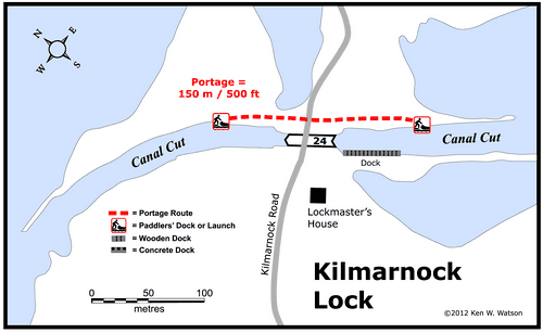
| Of Interest: Kilmarnock, originally known as Maitland’s Rapids (after the first settler, James Maitland), is a peaceful solitude lock, featuring a beautiful Unequal Arm, Center Bearing timber swing bridge and the lowest lift of any lock on the Rideau (only 2.2 feet / 0.7 m). The tranquil beauty of this lock belies the difficulties of its construction; problems with large boulders in soft mud and worker sickness cause Colonel By to reduce the height of the dam and the depth of lock excavation in order to speed up construction. This lock also features a two storey stone lockmaster’s house and, just up the road, is the Kilmarnock Apple Orchard.
|
| Notes: Very quiet - a solitude lock. No local services. |
|
* Time to actually go through the locks. Allow at least twice this time when trip planning. See Schedule Caveats.
1) GPS data should not be used for navigation. See the GPS page.
2) Washrooms are wheel chair accessible.
3) Unless indicated otherwise, water at the lockstation is potable.
4) Includes both blueline and greyline docking - see Lockstation Docking Page.
5) Because of the location of shore power at Kilmarnock Lock, electrical service is available only during non-operational hours (after daily closing until daily opening times posted in fees/hours brochure).
6) Allows tent camping for those arriving by water and also for cyclists and hikers.
|
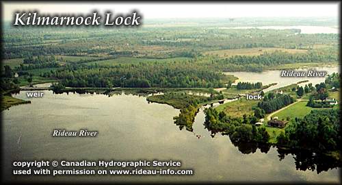 |
Kilmarnock Lock looking EastAnother quiet solitude lock. The lock is actually situated at the north end of Kilmarnock Island. A dam at the south end of the island and a weir north of the lock provide for the navigation depth in the river upstream of the lock.
photo copyright © Canadian Hydrographic Service - used with permission |
Comments: send me email: Ken Watson
©1996- Ken W. Watson
|