Your location: Rideau Canal Home Page > Rideau Lockstations > Long Island Locks 14-16
| Number of locks: 3 (in flight) |
Total Lift: 7.7m ( 25.3 ft.) |
Lock Through Time: 45 min.* |
| Chart No: 1512 (Sheet 1) |
GPS:1 N 45° 15.050' W 75° 42.115' |
| Chart Sales: Yes |
Lockstation Tel: 613-692-3030 |
| Washrooms: Yes2 |
Drinking Water: Yes3 |
Day Use Docking: Yes |
| Overnight Mooring: Yes |
Docking4 Upstream:
107m/350' |
Docking4 Downstream:
133m/436' |
| Ice: No |
Power: No |
Boater Camping:5 Yes |
| Boat Launch: No |
Picnic Tables: Yes |
BBQ Grills: No |
| Parking: Yes |
Public Telephone: No |
Self Guided Trail: No |
| Hwy Access: 1 km west of Hwy 19 (River Road) |
Locks Connect: Rideau River to Rideau River |
| Civic Address: 390 Nicolls Island Road, Ottawa, Ontario |
| Special Notes: To ensure passage, boaters must arrive at least 1.5 hours prior to closing. There is a swing bridge w/ clearance of 1.1m (3.6 ft) - swings on demand. |
| Of Interest: Long Island features a beautiful pastoral setting and a large stone arch dam. Compare the construction quality of this dam to the dam at Jones Falls. It also has an interesting hand operated, centre pivot, steel through truss swing bridge. This is the location of the story of the “Sluiced Superintendent.” In 1899, Superintendent Phillips broke through a wooden manhole cover and was washed through the tunnel sluice into the lock, emerging without injury. By 1900, all the manhole covers on the Rideau had been changed to iron. Ask the lockmaster to tell you this story. In the nearby community of Manotick is Watson’s Mill, a beautifully restored 19th century stone mill, open to the public. |
| Notes: Gas is available upstream between Manotick & Kars (Hurst Marina). |
|
* Time to actually go through the locks. Allow at least twice this time when trip planning. See Schedule Caveats.
1) GPS data should not be used for navigation. See the GPS page.
2) Washrooms are wheel chair accessible.
3) Unless indicated otherwise, water at the lockstation is potable.
4) Includes both blueline and greyline docking - see Lockstation Docking Page.
5) Allows tent camping for those arriving by water and also for cyclists and hikers.
|
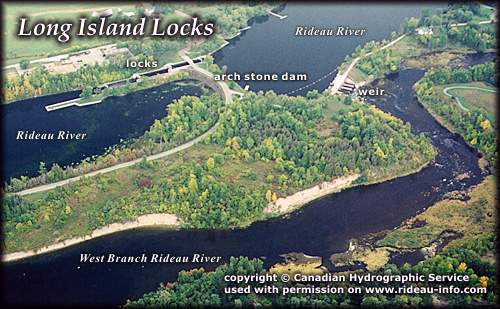 |
Long Island Locks looking SoutheastThe flight of 3 locks at Long Island marks the northern end of a section of the Rideau known as the "Long Reach", the longest section of the Rideau (25 mi/40 km) unbroken by locks. The next lock is at Burritts Rapids. Along the way are many intesting sights including Manotick, Kars and Kemptville as well as Rideau River Provincial Park and conservation areas. For more information have a look at the Long Reach Website.
photo copyright © Canadian Hydrographic Service - used with permission |
Comments: send me email: Ken Watson
©1996- Ken W. Watson
|