
Water Management on the Rideau - An Overview
The Rideau Waterway is a man-made system with water levels regulated by a series of control dams and reservoir lakes. It cuts across two watersheds, the Cataraqui River watershed, which drains water south to Lake Ontario and the St. Lawrence River, and the Rideau Basin watershed which drains water north to the Ottawa River.
 |
Profile of the Rideau Waterway
(Click on the picture for a detailed view) |
Prior to the Rideau Canal being built, the "Rideau Route" spanned three watersheds. One was the Rideau River watershed, basically as it exists today, the second was the Gananoque River watershed and the third was the Cataraqui River Watershed. It was these latter two watersheds that were altered, first by the buidling of mill dams and then by the dams of the Rideau Canal.
The story of the pre-canal landscape has been documented in The Rideau Route. In a nutshell, prior to about 1805, the top of the Cataraqui River Watershed were Dog and Loughborough lakes. Today, the top of the Cataraqui River watershed on the Rideau Canal is Newboro Lake (note, this is the top of the watershed on the Rideau Canal, but not the top of the full watershed). Prior to about 1805, Newboro Lake (then known as Mud Lake) was part of the Gananoque Watershed - water from it and other pre-canal lakes in this area (Clear, Indian, Opinicon and Sand) flowed, via the Whitefish River, to the Gananoque River.
In about 1805, a miller by the name of Lemuel Haskins built a mill dam at White Fish Falls (today's Morton). This blocked the Whitefish River and forced the water over the Cranberry Flood Plain to the Cataraqui River. Haskins had changed the watershed. This was made permanent by the building of a canal dam in the same location in 1826-1831. For maps illustrating this change see: The Rideau Route - Changing Watersheds.
While Haskins was the first miller to make a dramatic watershed change to the area, other millers were taking advantage of water power along the Rideau Route. Mills back then depended on waterpower. Any place that had a 5 to 10 foot head (elevation difference) of water made for a potential mill site. Water provided power to turn things - a grindstone to mill wheat, a saw blade to cut timber or a loom to make cloth.
When it was decided to build the Rideau Canal, several surveys were done of the route. The idea back then was to work with nature as much as possible. Everything had to be done by hand, and less work meant a cheaper cost. Colonel John By, who headed up the canal building project, decided to go with a slackwater system in order to gain navigation depth. In many conventional canals of the day, rapids were bypassed by digging a canal ditch around them. By decided to use locks and control dams to raise the water level of several sections of the waterway to drown rapids. This did two things, it made for cheaper construction costs (less rock excavation) and it turned rivers and swamps into lakes, providing navigation depths without the need for extensive excavation.
By was well aware of the dangers of spring flooding. Water can be controlled to a degree, but hydraulic pressure is an awesome force. By needed to design a system that could hold back water in order to maintain navigation depth, as well as release the torrents of water produced by the snow melt.
There were four design elements that By used to prevent water damage to the locks. First, at most of the lock sites he built waste water weirs, which are water control dams separate from the main lock. These dams have stop logs that can be dropped in or lifted out to control how much water is released. The bulk of the water that flows from lake to lake and from lockstation to lockstation goes through these waste water weirs. At only a couple of the lockstations did he dispense with the waste water weir and opt for the more conventional overflow dam (a dam that extends the full width of the river with water flowing over it).
 |
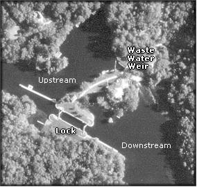 |
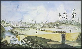
| The old painting of Chaffey's Lock in 1833 (above) and the airphoto of Davis Lock (right) show how a waste water weir works. The stop logs (still used today) are visible in the Chaffey's Lock painting. |
|
Secondly, at many of the locks, he raised the height of the lock to provide a flood guard. This "guard", usually in the range of 2 to 4 feet, meant that flood water could not overflow the lock (which would likely destroy it). Rising water would find another route, bypassing the lock. It would be much easier and cheaper to repair a damaged earth dam or waste water weir than to repair a flooded-out lock. One lock (Hog's Back) actually has a "guard lock" to protect the lift lock from spring flood.
Thirdly the abutments (ends) of the locks were rounded and slots put in to allow for stop logs to be dropped in. The stop logs allowed the lock to be fully drained for repair work, but they also prevented ice from exerting pressure on lock gates and the lock basin. The rounded abutments better resisted both ice and hydraulic pressures than square abutments would have.
Fourthly, By put in automatic flood control gates at two locks. By was worried about the effect of a catastrophic flood. Such a flood could be man-made with the destruction of a upstream dam or lock. The resulting onslaught of floodwater could destroy additional locks downstream. One such gate was placed in the channel above Newboro. A sketchy description shows it to be a wooden structure that would lie flat on the bottom of the channel. Rushing floodwaters would trigger it to rotate into an upright position, forming a barrier to the rushing floodwaters. The water of course would flow around it, but this gate would buffer the effects of the initial onrush, preventing major damage to the lock. A second flood gate was put in at Upper Brewers after a mill dam did in fact fail in 1832, almost destroying the lock ( see the story of The Wall of Water). These gates never saw actual use and no longer exist.
In addition to these physical flood control mechanism, it was Col By who initiated the procedure of drawing down the water in the canal system during the winter, opening up the weirs to drop the water level as low as possible, in order to provide holding capacity in the spring, allowing the controlled release of the spring freshet. This procedure is still in use to this day.
The Early Years
Colonel By was quite aware of the Rideau as an integrated hydrologic system. In fact he advocated restricting the use of land and water in the Cataraqui and Rideau watersheds. A basic principle of hydrologic systems is the retention of water within a watershed. Forests and swamps have lengthy retention times. An inch of rain that falls in a forest or swamp may take three weeks to fully drain into the waterway. That same inch falling on cleared farmland will drain away in a few days. Water falling in an urban environment drains away in a matter of hours. Evaporation on cleared areas also means that less water reaches the lakes and rivers of the watershed.
The issue of water retention within the watershed relates to the need to maintain navigable water depths throughout the whole of the waterway. To maintain this depth, water lost through river flow, lake evaporation and transpiration must be replaced. During the summer on the larger lakes, evaporation can account for a drop of up to 1 centimetre per day. Before the clearing of land for farming and urban development, the system was almost self-regulating. Rain falling in the region was buffered by forests and swamps. Water flow continued into the waterway even in periods of drought.
However, as forests were cut down and swamps drained, it became more difficult to maintain consistent water levels in the waterway. This was particularly apparent in the Cataraqui Basin watershed. In the latter half of the 19th century, several lakes in the watershed had to be dammed to become reservoir lakes for the Rideau. These lakes in effect replaced the forests that had been cut down, allowing water to be retained in the system and released as needed. In the Rideau Basin Watershed, the presence of a very large lake system at the top of the watershed, along with the Tay River and associated swamplands, continued to provide the needed water retention.
In the very early years, another problem was the lack of communication between lockstations. Messages had to be carried between lockstation by a person on foot, horseback or boat. Lockmasters lived at the locks and were on duty 24 hours a day. They were instructed to keep a close eye on water levels, to release water at the first sign of the spring freshet, and to retain water as much as possible during the summer and fall navigation season. The advent of the telegraph and later the telephone made the co-ordination of water control efforts much more efficient.
Another problem was the competing interest for water. In the early years, this competition came from the mill owners. The retention of water to maintain navigable water depths sometimes conflicted with a mill's need to run water through its water wheels and later, turbines. This led at times to conflict.
Twentieth Century
As the Rideau entered the twentieth century, several new man-made demands were placed were on the system. A new breed of water user, the cottager, appeared. This added a new expectation regarding water levels since those living on the waterfront don't want structures such as boathouses and docks to be damaged by fluctuating water levels. As the twentieth century progressed, another use for the water, hydro-electric power generation, also competed for use of the water. In several cases existing structures, such as the dam at Jones Falls, were used for hydro-electric power generation. At Jones Falls a tunnel was excavated through the stone arch dam. This tunnel was connected to wooden sluiceways that took the water to power generation turbines. Another demand for water was made by growing municipalities such as Smiths Falls which needed water from the Rideau for their municipal systems.
As the century progressed, it became clear that other factors such as the flora and fauna along the Rideau must be taken into account. A dramatic shift in water levels at the wrong time of year can have a negative impact on the spawning beds of fish. Many species of plants and animal along the Rideau depend on a constant flow of water to maintain their habitat.
So, this takes us to the present. The current water management program must try to juggle the needs of many, sometimes competing, interests.
Today
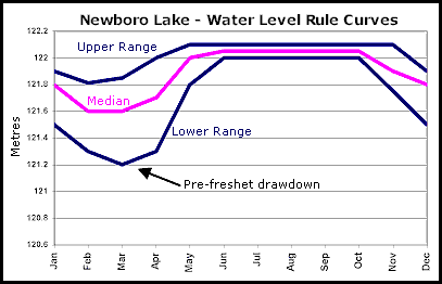 Each section of the Rideau is governed by a water level rule curve. A rule curve is the ideal water level that the lake or river should have at any point in the year. In many of the lakes the fluctuation is about 0.5 to 1 metre, maintaining high levels in summer and then allowing the lakes to drop down to normal winter levels after navigation closes in the fall. In the spring, the amount of snow pack determines how much the lakes must be drawn down in order to provide a reservoir to hold back water and prevent downstream flooding. Each section of the Rideau is governed by a water level rule curve. A rule curve is the ideal water level that the lake or river should have at any point in the year. In many of the lakes the fluctuation is about 0.5 to 1 metre, maintaining high levels in summer and then allowing the lakes to drop down to normal winter levels after navigation closes in the fall. In the spring, the amount of snow pack determines how much the lakes must be drawn down in order to provide a reservoir to hold back water and prevent downstream flooding.
In the past, historic records and past practises gave direction on how to properly maintain water levels. Today, this information and a host of other data such as levels of snow pack, precipitation and flow measurements are all incorporated in a computer simulation of the waterway to help give direction on how to maintain the lakes and rivers as close to the rule curve as possible.
Of course nature can still intervene and ruin the best-laid calculations. The summer of 1999 was such an example, where exceptionally low summer precipitation led several lakes to drop below their rule curve and in a couple of cases, drop slightly below minimum navigable water depth (5 feet). It is to be noted, that due to the small size the watersheds, no matter what the water level in May, if the Rideau area goes into drought, water levels will be dropping by mid-late July.
In the past, before computer simulations, techniques were based on past experience. Some buffering was also built in the system, for instance, it was common practise to take Big Rideau Lake above its normal upper limit in the spring, in order to provide some extra water in case it was needed in the event of a dry summer. Cottagers' complaints put a stop to this practise. If the hot and dry summers of late continue, this practise may have to be reinstated.
Ottawa Reach
The canal section in Ottawa is emptied each fall and raised back to navigation level in the spring. It is also partially re-filled in the winter for the skateway. The exact timing of all of this is variable. It is usually emptied about a week or so after the canal closes in the fall. It is refilled in the spring, generally in late April (the 2011 date was May 3 - the 2012 date was April 28). To get the exact dates, contact the Rideau Canal Office of Parks Canada: RideauCanal-info@pc.gc.ca
|
Competing Interests
Cottagers - a cottagers' main interest is protection of property and the recreation use of the waterfront. A flooded dock or prop-busting shallow water can lead to complaints. Some are valid, some are not. Cottage owners should be aware of the rule curve for their lake, as well as historic maximums and minimums. A floating dock is a wise choice to accommodate fluctuating water levels as well as being the soundest environmental choice.
Boaters - a boater's main interest is navigation depth. The minimum depth is normally 1.5 metres (5.0 feet) in the navigation channel. The navigation charts show depths based on the minimum summer rule curve level. So, if the water level dips below the minimum rule curve, then the charts numbers are no longer valid. Another issue is docking. The fixed docks at marinas and lock stations are based on the median rule curve. If water dips too low, it can be a bit of a chore to climb up onto the dock from a small boat.
Fish & Wildlife - the Rideau is home to many species of fish and wildlife that depend on the water. Water levels are adjusted to accommodate the needs of these local residents. In fall, several of the lakes are dropped quite quickly to winter levels. This is to accommodate trout spawning since trout spawn in shallow water. Water levels have to be taken down to winter level before they start to spawn, otherwise the spawning beds the trout pick would end up high and dry, or ice damaged in winter. Lakes are generally held to these levels until at least February 1, in order to lessen the impact on animals such as muskrat and beaver, which have hibernated in dens based on these winter water levels.
A complaint heard in the summer of 1999 was that water was still being let through at Smiths Falls, even though Lower Rideau Lake was falling below chart datum. A constant minimum flow must go through Smiths Falls to supply the Rideau River with water; you can't just shut off the flow. Part of this has to do with urban development in the northern Rideau (Ottawa) area. As swamps are drained for development, water-retention capacity diminishes, and more demands are required of the headwaters (Tay River, Big Rideau Lake, Lower Rideau Lake) to supply water to the Rideau River.
Hydro-electric Power Generation - generating plants are located at Kingston Mills, Washburn, Brewers Mills, Jones Falls, Smiths Falls, Merrickville and Rideau Falls in Ottawa. The generating plants operate under a lease agreement with the Parks Canada, and are allowed to take a certain amount of water. The need to maintain navigation depths in the Rideau takes precedence over power generation. Water fluctuations in certain lakes can sometimes be attributed to draw downs for the purposes of power generation.
Urban Residents - some urban communities use water from the Rideau Waterway for their municipal supplies. Water management of the Rideau is also a significant factor in flood control, particularly of the northern (Ottawa) area.
View Rule Curve Levels
|