THE SETTING
What is the Rideau Canal?
The Rideau Canal is a series of rivers, lakes and connecting locks and canals that form a continuous waterway from Kingston to Ottawa, in eastern Ontario, Canada. It is 202 kilometres (125 miles) long, of which about 19 kilometres (12 miles) is man made (locks and canal cuts), the rest are natural waters. There are 45 locks in 23 lockstations along the main route of the Rideau plus 2 locks that link the Tay Canal to the Rideau. From Lake Ontario at Kingston the canal rises 50.6 metres (166.2 feet) to the summit of Upper Rideau Lake and then descends 83.8 metres (275 feet) to the Ottawa River at Ottawa. To view location maps, head over to: www.rideau-info.com/canal/maps.html (click this link).
Why is the profile shaped like a hump?
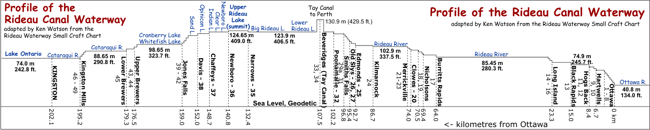 This is because it crosses a watershed divide located just north of the Newboro Lockstation. Water on the north side of divide – Upper Rideau Lake and north on the Rideau Canal – flows to the Ottawa River. Water south of the divide – Newboro Lake and south on the Rideau Canal – mostly flows to Lake Ontario. The reason for this divide is the topographic remnant of the very old Grenville mountain range which forms today’s Frontenac Axis (see map in Geology section), part of the Canadian Shield (very old rocks). When you boat the Rideau Canal from Kingston to Smiths Falls you are literally boating over a mountain.
Of note, a common misconception is that Upper Rideau Lake and Newboro Lake are at the top of their respective (Rideau Valley and Cataraqui) watersheds. They are not. While they are the highest water point within each watershed on the Rideau Canal itself, both have water flows into them from upland lakes and streams. Some of these are reservoir lakes for the Rideau Canal (i.e. Devil & Wolfe lakes) that help to supply water to the Rideau Canal in times of drought.
In the pre-canal era there were two watershed divides. Water from Newboro Lake and the original southern lakes (Clear, Benson, Indian, Opinicon and Sand) flowed to the Gananoque River via the White Fish River which had the Jones Falls Rapids (which flowed out of Sand Lake) as its headwaters. The Cataraqui River’s headwaters were Loughborough Lake and the pre-canal Dog Lake. A mill dam at Morton (c.1803), replaced in 1831 by a canal dam, blocked the flow to the Gananoque River, forcing it to the Cataraqui River. This remains the configuration today.
Can I paddle all of the waterway?
Yes – the Rideau is ideal flatwater paddling, so everyone from the novice to expert can do it. Canoes and kayaks are welcome to travel through the locks (there are no restrictions other than the required fee permit – see below). Canoes and kayaks can also portage (for free) around the locks if they wish. All lockstation with the exception of Ottawa and Smiths Falls Combined provide camping areas for boaters (a fee applies, see below), a few offer oTENTiks (canvas covered A-frame cabins), plus there are a number of private campgrounds and two Provincial Parks along the route.
Who Operates the Rideau?
The Rideau is operated by the Parks Canada Agency, which is under the authority of the Canadian government Department of Environment. They maintain the heritage aspects of the canal and operates it much like a park.
When and why was it built?
It was built between 1826 and 1832. It pre-dates the locks on the St. Lawrence, and was built to assist the defence of Canada by allowing boats to travel from Montreal to the Great Lakes without having to travel down the St. Lawrence, in gunshot range of the Americans. It was officially opened in May, 1832 and has been operated continuously ever since.
Who built it?
It was built by the British under the direction of Lt. Colonel John By of the Royal Engineers. Private contractors, such as John Redpath and Thomas McKay, did most of the actual construction. The design and engineering of the canal was done by Colonel By and the Royal Engineers. Two companies of Royal Sappers and Miners assisted in the construction. Hundreds of tradesmen (i.e. masons, carpenters, smiths, coopers) used local materials to fashion the locks and dams. The large amount of manual labour (i.e. digging dirt, chopping trees, excavating stones) was done by thousands of immigrant Irish and French-Canadian labourers. Local settlers assisted with moving materials (i.e. stones) and providing food to the work camps. Some 2,500 to 4,000 men worked on the construction each year. Many women and children were also part of these construction camps. For details about the construction, visit the History of the Rideau Canal webpage at: www.rideau-info.com/canal/history/ (click this link).
What makes the Rideau unique?
It is the oldest continuously operated canal in North America. Most of the locks are still operated by hand, using the same mechanisms that were used to operate the locks in 1832. As you travel the Rideau, you are viewing living history. The Rideau isn’t just a canal cut (only 10% is man-made), it’s a waterway combining canals, rivers and lakes. This makes the Rideau a wonderful blend of urban, rural and natural landscapes. You can see million dollar homes, quaint cottages, and loons swimming in a sheltered, undisturbed bay, all in the same day.
How has the Rideau been recognized?
On May 15, 1925 the Rideau Canal was designated a National Historic Site of Canada. It was re-designated with exanded reasons in 1967 and again in 2011. For the history of the Rideau's National Historic Site designations see the: Rideau NHS page. The 2011 designation wording is:
- built between 1826 and 1832, it is the best preserved canal from the great canal-building era in North America that is still fully operational: its historic structures and environment speak to its ingenious design, construction, and military purpose, as well as to its social and economic functions;
- it exemplifies cutting edge canal design due to Lieutenant-Colonel John By’s innovative “slackwater” approach, which created a navigable route from natural waterways and lakes on a scale previously unseen in North America, and because it was one of the first canals in the world engineered specifically for steam-powered vessels;
- its construction through more than 200 kilometers of bush, swamps, and lakes was a monumental feat. Each year, as many as 5,000-6,000 workmen assembled at over two-dozen worksites. The great majority of the labourers were Irish and French Canadian toiling under the supervision of contractors and the Royal Engineers. Working primarily with hand tools and in extremely difficult and dangerous conditions, these labourers and skilled craftsmen, such as Scottish stonemasons, endured disease and injury, with large numbers dying during the canal’s construction;
- in the aftermath of the War of 1812, when relations with the United States were tense, it was built to serve as a military canal and represented a fundamental component of Britain’s defences in the interior of North America, safeguarding the supply lines between Montréal and Lake Ontario by providing an alternative and more defensible route to that along the St. Lawrence River;
- it contributed significantly to the social and economic development of Upper Canada / Ontario prior to 1850, when it was a key artery for the movement of goods and people in and out of the colony. After that time, it continued to be of local commercial importance until the 1930s; since then it has served as a popular recreational route."
In 2000 the Rideau Waterway was designated a Canadian Heritage River in recognition of its outstanding historical and recreational values.
In 2007 it was inscribed as a UNESCO World Heritage Site recognizing it as a work of human creative genius. Two criteria were used as the basis for the designation:
- The Rideau Canal remains the best preserved example of a slackwater canal in North America demonstrating the use of European slackwater technology in North America on a large scale. It is the only canal dating from the great North American canal-building era of the early 19th century that remains operational along its original line with most of its original structures intact (UNESCO Criterion i)
- The Rideau Canal is an extensive, well preserved and significant example of a canal which was used for a military purposes linked to a significant stage in human history - that of the fight to control North America (UNESCO Criterion iv)
PADDLING THE RIDEAU WATERWAY
What type of Canoe/Kayak do I need?
Any type of canoe or kayak will do. Since it is flatwater paddling, the ideal canoe is a “tripping” style of canoe. Kayakers will prefer a sea kayak with some cargo capacity for carrying gear. If you have a choice, a kayak is preferable over a canoe since kayaks can handle wind and waves (which can be problematic for canoes at times in the larger lakes) much better than a canoe.
Are the any difficult sections?
The sections that canoeists in particular should pay attention to are the lakes with large expanses of open water. These include Big Rideau Lake, Upper Rideau Lake, Colonel By Lake and River Styx. If the wind is blowing, these lakes can get quite rough. On the other lakes (which can also get rough in stormy weather) there are enough nearby nooks and shelters that a canoeist can easily avoid rough water. However, with a prudent eye to the weather and sticking close to shore, all the lakes, including Big Rideau, Upper Rideau, Colonel By and River Styx can be a very enjoyable paddle.
Are there other paddling issues?
One should be aware of where the navigation channel lies and of cruisers that travel along that navigation way. When travelling at speed, these cruisers can create large waves (wash) and not all are considerate of the poor paddler. However, cruiser traffic volume on the Rideau is low and it is quite easy to be aware of that cruisers and avoid problems with their waves. It is often best for paddlers to take the scenic route and travel off the navigation channel.
Do I need any special gear?
You should pack as you would for any normal paddling trip, making sure you are carrying all the required safety gear. A note to kayakers is that you might wish to carry a spray skirt in the event of wavy or rainy weather. While I've never had a problem with water in my kayak, even in the "worst" conditions on the Rideau (white cap waves), I'm doing day trips with a lighter load than would be the case with a multi-day trip. I received a note from one kayaker who took on water in wavy conditions on Lower Rideau Lake (he didn't have a spray skirt). I also carry a hand pump on the bow of my kayak.
Do I need a map?
Yes – there are a few of choices, the 1:50,000 NTS maps, the 1:20,000 hydrographic charts or the maps in this guide (which are 1:50,000 when printed out at 8.5” x 11”). A good map is very worthwhile since it shows all the islands and shorelines and allows you to explore all the interesting nooks and crannies that would otherwise be missed if you simply followed the marked navigation way. So a good set of paper maps is highly recommended. GPS units are handy, are but not a substitute for carrying paper maps.
Some paddlers like the NTS maps since these show detailed topography and tributaries that connect to the Rideau, features that may be of interest to the paddler. Six 1:50,000 scale NTS maps cover the waterway, from south to north they are 31C/8, 31C/9, 31C/16, 31B/13, 31G/4 and 31G/5.
Other paddlers prefer the hydrographic charts, since they are the most detailed maps of the Rideau (1:20,000) and include detailed insets of all the locks. The charts also clearly show all the numbered marker buoys (giving you a quick clue to your location on the open water). Chart 1512 covers from Ottawa to Smiths Falls and Chart 1513 covers Smiths Falls to Kingston.
The maps in this guide are highly detailed and can certainly be used for all paddling purposes. This guide also includes individual lockstation maps and a subset of the marker buoys.
Another resource that can be helpful (or at least interesting) is Google Earth – much of the Rideau is covered by high resolution satellite imagery, so you can see exactly where you plan to go. Their path tool is handing for measuring paddling distances.
For those carrying a GPS unit, the "MapSource Topo Canada" GPS maps are handy to have since they include the entire Canadian NTS series maps. It is still advised that you carry a paper set of maps in addition to your GPS unit in case the batteries run out, or, if you have a non-floating GPS, you accidently drop it overboard (many waterproof GPS units don’t float – test yours before you head out).
Digital maps are also available for smartphones. In addition to native map apps that come with your phone, there are apps for both the NTS topographic maps and for the hydrographic charts. For instance, for NTS topo maps, the "Canada Topo Maps" app by Atlogis provides all the topo maps for Canada (only for Android as of this writing). For navigation charts there are apps for both Android and iOS such as the "Navionics Marine&Lakes: US&Canada" app which has the full hydrographic charts for the Rideau Canal. Ensure that whatever you plan to use allows for offline use of the maps (to cover connection dead zones that exist on the Rideau) – make sure you download them onto your device before the trip.
For more information about maps that cover the Rideau, have a look at the maps page: www.rideau-info.com/canal/map_list.html (click this link).
Do I need to wear a Lifejacket?
Yes and no. YES if you are using an inflatable PFD (either auto or manual inflate), then it MUST BE WORN. This rule applies to any open boat, power or paddle and applies to all canoes and kayaks (the OPP are enforcing this rule). NO if you have a regular Canadian approved PFD/Lifejacket, of appropriate size, for everyone on board. If not worn, the PFD/Lifejacket must be readily accessible (not buried inside a sealed hatch).
2024 Note: There is a law pending in Ontario that will make it mandatory for any child, 12 years old or younger, to wear a child approved lifejacket or PFD at all time while onboard any vessel. To quote the pending legislation, they must “wear a personal flotation device or lifejacket while on a pleasure boat that is underway or while being towed behind the boat while using recreational water equipment.”
When is the Rideau open for boating?
The locks operate from mid-May to mid-October. For exact dates see the fees & schedules page located at: www.rideau-info.com/canal/fees.html (click this link). Of course with so many sections of natural water, you can paddle anytime there is open water and for those willing to portage, the navigation season (when the locks are open) is not a restriction.
Do the locks operate 24 hours a day?
No - the hours vary. During most of the season the locks open at 9:00 am (10 am during weekdays in the spring and fall). In the summer they stay open until 6:00 pm from Monday to Thursday and 7:00 pm from Friday to Sunday. In spring and fall they generally close at 4:00 pm on weekdays and 5:00 pm on weekends. For full details see the fees & schedules page at: www.rideau-info.com/canal/fees.html (click this link).
What is the preferred direction of travel?
Prevailing winds are from the west-southwest (direction of the jet-stream), so it can be a bit easier paddling northeast, from Kingston to Ottawa. Of note, winds are more unpredictable in the fall (storms moving up the east coast of North America can drive winds inland, creating an east wind). In terms of currents in the rivers, since the Rideau traverses two watersheds, you will be with or against minimal currents both ways. The southern half of the Rideau (Cataraqui Watershed) flows south while the northern half (Rideau Valley Watershed) flows north. However, since the Rideau is a “slackwater” system, there are no appreciable currents to contend with.
If you are portaging your canoe/kayak and only doing one section of the Rideau, consideration might be given to heading "down" rather than "up" to make portaging easier. If you're doing the entire Rideau this is not a consideration since half will be "down" and half will be "up".
If you are a photographer or videographer, going from Kingston to Ottawa will put the sun at your back, as you face forward, allowing for better quality photos.
How long does it take to paddle the Rideau?
How fast do you paddle? This is a question almost impossible to answer on a general basis. My cruising speed in a kayak (minimal stops) is about 5 kph, but my puttering speed (photo stops, pit stops, drifting breaks, snack breaks, lunch break, leg stretching breaks, etc.) is about 4 kph. A tandem canoe should be about the same. The direct distance along the route of the canal is 202 kilometres (if you don’t take any side trips) and in addition the paddling, there are 24 lockstations to lock through or portage around. A very general rule of thumb is to allow 6 to 10 days to do the journey. The Rideau contains 292 islands and 1091 kilometres of shoreline in addition to several tributaries and feeder lakes – so you could spend as long as you like and still find new areas to explore.
How much does it cost to go through the locks?
You can portage around the locks for free or pay a fee and go through the locks. Parks Canada charges a fee by the foot (12 foot minimum). The following are based on 2026 fees. A season pass is $11.25 per foot. If you just want to go through one lock, it will cost $1.50 per foot. There are various other options (one day, 6 day, transit pass). So, if you’re in a 16 foot canoe, a single lockage and return would cost $24.00, and a pass for the entire season would cost only $180.00 (pretty inexpensive to save you all that portaging). For full fee information visit: www.rideau-info.com/canal/fees.html (click this link).
Can I portage the locks?
Certainly. Portaging is sometimes faster than locking through (depending on how much gear you have to lug) and provides more exercise. All lockstations now have specific paddling dock (a low floating dock) making it easy to take a canoe/kayak in or out. The lockstations also have portage routes, marked at either end with signs. These portage routes are shown as map insets in my Paddling Guide to the Rideau Canal. Of note, Parks Canada recommends that portaging not be done at Smiths Falls Combined, and Old Slys due to dangerous road crossings. Currently Parks Canada offers free lockage for paddlers at those locations. At Smiths Falls Detached and Merrickville, which also have dangerous road crossings, the lock staff will lower the swing bridge barriers to facilitate a safe crossing.
Where can I make Pit Stops?
Washroom facilities are available at all the lockstations as well as parks, conservation areas, marinas and campgrounds. Of note with the lockstation is that some these can be closed at night if no one is staying at the lockstation (something to be aware of if you arrive late). Answering the call of nature between these locations can be technically problematic since most of the land bordering the Rideau is privately owned. However, quite a bit of waterfront (almost 50%) and many islands remain undeveloped along the Rideau - so (and you never heard it from me) - if you have go, keep your eye out for an undeveloped spot. Please leave the area undisturbed.
Can I consume alcohol or cannabis (marijuana) while paddling?
No. The law in Ontario regarding alcohol and cannabis in any vessel (including canoes and kayaks) is the same as it is for a motor vehicle. If you’re found to be impaired, your driver's licence will be automatically suspended for 90 days and you'll be subject to impaired "driving" penalties. Any liquor in a boat must be in a container that is unopened and the seal unbroken; or stored in a closed compartment. Cannabis must be in a closed or fastened container out of the reach of the paddler.
Where can I park my vehicle?
There are a number of options for vehicle parking. One option is a campground – some provide parking space for your vehicle while you are away on your trip. Contact the individual campground first. A listing of campgrounds can be found at: www.rideau-info.com/canal/accommodations.html(click this link).
Another option is the lockstations, several offer weekly parking rates. However, be aware that the parking lots are unsupervised and Parks Canada does not recommend leaving your vehicle for extended periods.
Can I rent a canoe/kayak?
Yes - there are a few options. Currently, canoes and kayaks can be rented from Frontenac Outfitters, Ahoy Rentals, Big Rideau Lake Boat Rentals, Perth Major Outfitters and Trailhead. For more information visit their websites which you will find linked from www.rideau-info.com/canal/boat_rent.html (click this link).
What should I bring to fully enjoy the Rideau experience?
The Rideau is not only a lovely waterway to paddle, it is also an historic waterway. A copy of Ken Watson’s "A History of the Rideau Lockstations" is a must have, it provides an historic visitors guide to the locks. Ken's book "The Rideau Route: Exploring the Pre-Canal Waterway" (only available as a free PDF)is of interest to paddlers since it documents the early surveys of the Rideau (done using birch bark canoes). Other very interesting history books are Robert Legget’s "Rideau Waterway" and Robert Passfield’s "Building the Rideau Canal: A Pictorial History". A good selection of Rideau books is always available at Friends of the Rideau's Depot outlet in Merrickville, open during the summer months.
Where can I find more information about paddling the Rideau?
The best place to start is the canoeing/kayaking section at www.rideau-info.com/canal/paddling/ (click this link). It contains a trip planner as well as detailed paddling guides. The most comprehensive paddling guide is Watson's Paddling Guide to the Rideau Canal available as a free PDF download. The 18 sections of that guide are also available as separate web pages and separate PDF downloads so that they can be easily used by the day paddler to paddle any section of the Rideau.
CAMPING ON THE RIDEAU WATERWAY
Where is the best place to camp?
The lockstations are the most convenient. Camping is allowed at 23 of the 26 lockstations (only Smiths Falls Combined, Hogs Back and Ottawa don’t have camping facilities), plus Colonel By Island. There is a fee for camping, either a mooring permit for your canoe/kayak or just a camping fee (most people prefer to pull their canoe/kayak out of the water and therefore pay the camping fee). A few lockstations also offer oTENTiks (a canvas covered A-frame cabin). Those are best reserved in advance, but are available on a by chance basis if you arrive during operational hours and one is available. Each oTENTik can sleep up to 6 people. There are also several private campgrounds along the Rideau that offer more facilities than available at the lockstations. In addition, there are two provincial parks, Murphy’s Point and Rideau River that offer camping options. For listings of private campgrounds, check the accommodations page at: www.rideau-info.com/canal/accommodations.html(click this link).
Can I Reserve a Campsite at a Lockstation?
Generally no, Parks Canada uses an on-demand system allowing you to pitch your tent on one of the lawns at the lockstation so there is always room. This “on-demand” camping is an advantage for the paddler since it means you don’t have to stick to a specific schedule, if you get delayed by weather, you’ll find camping at the next lockstation. Note, Parks Canada has recently started to offer reservable spots at a few lockstations (contact Parks Canada for details), but those places also have on-demand camping which is more convenient for the paddler (or any boater who wishes to camp at a lockstation).
What camping services are offered at lockstations?
All lockstations offer toilets, picnic tables and water (check with the lockstaff at each lockstation regarding potability). Many also offer BBQ grills and a few lockstations sell ice. Only lockstations with oTENTiks offer showers. Camping usually involves pitching a tent on the lawn of the lockstation. Large shade trees are present at many lockstations. For more information on lockstation services see: www.rideau-info.com/canal/lock-services.html (click this link). For information about camping at a lockstation see www.rideau-info.com/canal/lock-camping.html (click this link).
Are there non-camping options?
Yes – there are many B&Bs (regular and airbnbs), motels, inns and lodges that line the Rideau. Unfortunately at this time there is no indication of which of these will directly cater to the canoeist (i.e. offering a pull-out and overnight storage of canoe and gear), so it best to ask each potential accommodation directly. You can find listings of B&Bs and hotels on various tourism websites.
Do I have to stock up on supplies?
No - there are many services available along the Rideau. There are several communities along the Rideau that have grocery stores within easy walking distance of a docking area so you can stock up on food, ice, drinks, etc. You’ll find links to many of the towns, with maps and a listing of services from the maps page at: www.rideau-info.com/canal/maps.html (click this link).
May I have an open fire while camping at a lockstation?
Only in the designated BBQ grill. You may burn charcoal or wood. If you plan to burn wood, you must bring your own since Parks Canada does not sell campfire wood or allow it to be cut or scavenged on site. The exception to this are sites with oTENTiks which do offer firewood for sale. If you bring your own wood they ask that it not be ash because of the risk of importing the emerald ash borer insect.
May I use a camp stove?
Yes – using the appropriate fuel and following the manufacturer's safety guidelines.
May I drink alcohol at a lockstation?
No – the land (including wharfs) of a lockstation are considered to invite or allow public access and therefore no alcohol can be consumed on Rideau Canal property.
Can I consume cannabis at a lockstation?
Yes – Parks Canada's policy is that cannabis can be consumed in public use areas and also at a visitor's campsite (for those camping at a lockstation) and at oTENTiks. However, if smoking or vaping, please have courtesy and consideration of others. It is always best to check with the lock staff regarding permitted areas.
Where do I put my garbage?
All lockstations provide garbage cans (green barrels) and most also provide recycling options for aluminum and glass (blue barrels).
Can I charge my electronic device?
There is no official power for campers, however there are power outlets in the washrooms where you can plug in a charger (unsecure so you'll have to monitor your device while on charge).
Are there any wildlife issues?
No. The most common wildlife in the vicinity of most lockstations are muskrats, raccoons, porcupines and the occasional skunk. Deer are common in the area but not often seen. Black bears, while present in some areas, are extremely uncommon (there has not been a bear sighting at a lockstation in recent years). There are some snakes, none are venomous and they all keep away from people. Normal wildlife precautions, such as keeping food in well sealed containers, cleaning your meal dishes, and properly disposing of garbage should be taken.
It’s been reported that the Colonel By Island raccoons are experts at raiding food caches so make sure that yours is critter proof.
May I bring my pet?
Yes – however, while on the grounds of a lockstation, the pet should be:
a) restrained by a harness or a leash that is no longer than 3 m or
b) confined in a container or enclosure
and every person who is in charge of a pet shall ensure that any excrement or other solid waste that originates from the pet is disposed of in a receptacle. [Historic Canal Regulations]
OTHER
Can I go Swimming in the Rideau Canal?
Yes – EXCEPT in the immediate vicinity of any lock and in the Ottawa section of the canal, from Hogs Back to the Ottawa Locks (swimming is prohibited in this entire section). Water quality is generally fine for swimming. The exception can be near public beaches at times (they will be posted). Please use common sense and don't swim in narrow boat channels (there are lots of spots to go swimming away from boat traffic).
CONTACTS
Parks Canada Agency
Rideau Canal Office
34 Beckwith St. South,
Smiths Falls, ON K7A 2A8
Tel: 613-283-5170
Toll Free: 1-888-773-8888
Fax: 613-283-0677
email: RideauCanal-info@pc.gc.ca
website: www.pc.gc.ca/rideaucanal(click this link).
Friends of the Rideau
P.O. Box 1232, Stn. Main
Smiths Falls, ON K7A 5C7
email: info@rideaufriends.com
website: www.rideaufriends.com (click this link).
Leeds & Grenville Economic Development
c/o Ann Weir, Economic Development Manager
United Counties of Leeds and Grenville
32 Wall Street, Suite 300, Brockville, ON K6V 4R9
Tel: 613-342-3840 Ext. 5365 or 1-800-770-2170
email: econdev@uclg.on.ca
website: discover.leedsgrenville.com click this link.
FAQ compiled by: Ken Watson (rideauken@gmail.com)
Date Created: June 5, 2003
Date Updated: January 30, 2026
|