Your location: Rideau Canal Home Page > Rideau Lockstations > Narrows Lock 35
| Number of locks: 1 |
Total Lift: 0.9m ( 3 ft.) |
Lock Through Time: 15 min.* |
| Chart No: 1513 (Sheet 2) |
GPS:1 N 44° 42.180' W 76° 17.730' |
| Chart Sales: Yes |
Lockstation Tel: 613-539-7537 |
| Washrooms: Yes2 |
Drinking Water: Yes3 |
Day Use Docking: Yes |
| Overnight Mooring: Yes |
Docking4 Upstream: 152m/500' |
Docking4 Downstream: 116m/380' |
| Ice: No |
Power**: Yes (D) |
Boater Camping:5 Yes |
| Boat Launch: No |
Picnic Tables: Yes |
BBQ Grills: Yes |
| Parking: Yes |
Public Telephone: No |
Self Guided Trail: Yes |
Hwy Access: 7 km N of Hwy. 15
on Narrows Lock Rd. |
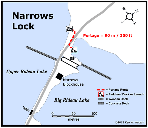
Lock Connects: Big Rideau Lake to Upper Rideau Lake |
| Civic Address: 1275 Narrows Lock Road, Rideau Lakes, Ontario |
| Special Notes: To ensure passage, boaters must arrive at least 30 minutes prior to closing. Swing bridge with a clearance of 1.2 m (3.9 ft). Bridge swings on demand. |
| Of Interest: The question you have to ask here is why is there a lock in the middle of a lake? It has to do with bedrock and malaria. When trying to excavate the canal cut through “The Isthmus,” the watershed divide at Newboro, hard bedrock was encountered. Seasonal malaria also impeded the work. To speed up construction and reduce the amount of excavation at Newboro, Lt. Colonel By came up with a plan to build a dam and lock here, at a natural narrowing of the lake. This raised the level of the portion of Rideau Lake on the west side of the Narrows, “creating” Upper Rideau Lake. One of the four blockhouses built on the Rideau is located here, to protect this important lock. Murphy's Point Provincial Park, located at the northern end of Big Rideau Lake (west shore) makes an interesting stop. |
| Notes: Closest gas is at Portland. There are no local services. Both Portland and Westport offer excellent opportunities for grocery and gift shopping as well as restaurants. |
|
* Time to actually go through the locks. Allow at least twice this time when trip planning. See Schedule Caveats.
** U = upstream side, D = downstream side
1) GPS data should not be used for navigation. See the GPS page.
2) Washrooms are not wheel chair accessible.
3) Unless indicated otherwise, water at the lockstation is potable.
4) Includes both blueline and greyline docking - see Lockstation Docking Page.
5) Allows tent camping for those arriving by water and also for cyclists and hikers.
|
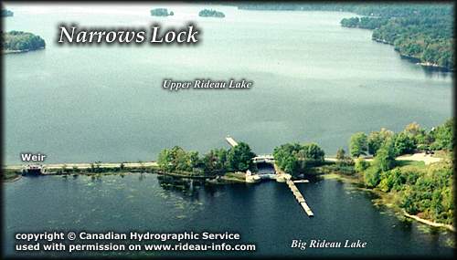 |
Narrows Lock looking WestWhy is there a lock in the middle of a lake? Narrows is one of the more unique locks in that it was constructed in order to reduce the amount of rock excavation required at "The Isthmus" (Newboro). The building of this lock kept the project on schedule and saved dozens of lives (from malaria). The Narrows lock raised the west end of Rideau Lake (now called Upper Rideau Lake) by almost 5 feet. The lift of the lock has since been lowered by the raising of the weir at Poonamalie.
photo copyright © Canadian Hydrographic Service - used with permission |
Comments: send me email: Ken Watson
©1996- Ken W. Watson
|