Colonel By Lake - Cataraqui River
When French headed south from Jones Falls in 1783, he continued down the White Fish River, through what is today Morton Bay, and to Lower Beverley Lake. The Cataraqui Flood Plain was dry land, an ash tree forest at the northern end (today’s Whitefish Lake), it wasn’t navigable by boat. However, today’s boaters float over the Cataraqui Flood Plain, flooded to a depth of about 17 feet (5.2 m) with the building of canal dams at Upper Brewers and Morton. At the southern end of this section, the Round Tail marks the location of the original channel of the Cataraqui River, which is 1783 had its headwaters in Loughborough Lake and pre-canal Dog Lake. Aboriginals travelling from Cataraqui (Kingston) would head up the meandering Cataraqui River to Loughborough Lake and then continue to Opinicon Lake via either Hart Lake or Lower Rock Lake.
The most extensive flooding of the Cataraqui River occurs in the area of Colonel By Lake and the River Styx. The dam at Kingston Mills raised the water 26 feet (7.9 m) in that location, flooding the Cataraqui River up to Lower Brewers lockstation. As previously noted, the author participated in a detailed survey of Colonel By Lake with an M.Sc. student from McMaster University, Lisa Sonnenburg and her thesis advisor, Dr. Joe Boyce. This work revealed the channel of the Cataraqui River as it existed prior to flooding, first by the mill dam erected at the King’s Mills in 1784, and then by the canal dam and embankments built in 1827-1831.
The Cataraqui River was a meandering creek, winding its way across a valley floor consisting of forest and some flood marshes. When the canal was built, a swath of trees on either side of the proposed navigation channel was cut – the rest of the forest was left standing and simply drowned when the canal dams were raised. The bathymetric work has revealed the exact location of the Cataraqui River just prior to flooding and the side scan sonar work has revealed hundreds of deadfall logs and still standing timber.
One of the reasons for this work was to help locate potential archaeological sites such as native campsites and early settler’s cabins, all now under water.
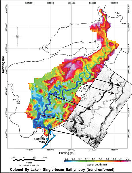 |
Colonel By Lake Bathymetry
The bathymetry (depth readings) of Colonel By Lake clearly shows the drowned channel of the Cataraqui River, now under 26 feet (7.9 m) of water. The actual trace of the creek compares well to John Burrows’ circa 1828 map of the creek. The outer line on the map is the present day outline of Colonel By Lake. The bathymetry is from an M.Sc. thesis completed by Lisa Sonnenburg in 2006. Burrows’ map is a section from: “Plan of the Cataraqui Creek from Brewers Lower Mill To Kingston Mills Scaled and Laid Down by Order and under the Command of Lt. Coln. By Commanding Royal Engineer Rideau Canal” by John Burrows, n.d. [c.1828], National Archives of Canada, NMC 13203.
|
|