|
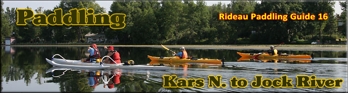
Paddling the Rideau River from
Kars N. to the Jock River
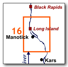
This is an easy paddling river section of the Rideau River which includes the northern part of The Long Reach, a section of the Rideau Canal uninterrupted by locks. The map included in this guide can be enlarged (while viewing the PDF) to any level of detail you desire as an aid for travel planning.
You can view or download the PDF file:
| (Clicking this link will open the PDF. You can also just right mouse click the above link and use "Save Target As" to send the PDF directly to your computer.) |

Water Access
There are several points of water access. To the south are the ramps in Kars (see Guide 14). In Manotick, there is the public ramp on the Rideau River at the bridge (45° 13.880'N - 75° 40.790'W). There is the Long Island Lockstation which offers lots of parking - paddlers can launch from the top (to paddle south) or at the bottom of the lock (with a bit of a portage) to paddle north. Those wishing to paddle north might find it easier to launch from Jock River Landing (45° 15.625'N - 75° 42.480'W), at the mouth of the Jock River, just off Lodge Rd. near the intersection with County Rd. 73 (Prince of Wales Drive).
Facilities
Lodging: If you're paddling and camping, the lockstations are a good choice for camp spots (a camping fee applies). There are a few B&Bs in the general area, plus a host of accommodations in Ottawa. For information about local accommodations see: www.ottawatourism.ca and www.rideau-info.com (this website).
Supplies: A local source for supplies is the town of Manotick which has which full facilities (grocery stores, pharmacies, hardware stores).
Big Boats
You'll be sharing the Rideau with big power boats (cruisers). The Rideau is generally not a crowded waterway and often you'll find the large boats in "packs" - travelling from lock to lock - once they pass by you won't see any for awhile. Some of these boats can generate a large wave. The general rule for a paddler and large waves is to meet them head on, this can actually be fun in a kayak (not as much fun in a canoe).
The main navigation channel is shown on the map as a blue dashed line - this is where the big boats will be travelling. So, if you wish to avoid these, pick a route away from the navigation channel. Many paddlers prefer paddling near shore, it's more interesting (i.e. wildlife, cottages) and it keeps you farther away from the waves produced by big boats.
There are several "no wake" zones on the Rideau - these have been marked on the maps. Boaters within these areas are supposed to be travelling at a slow enough speed (less than 10 kph) that their boat doesn't generate any potentially damaging or dangerous waves.
Wind
A question often asked is which way does the wind blow? The prevailing wind, powered by the jet stream, is from the southwest. That's about the only rule of thumb. If a front is moving in then the wind can come from any direction. I've been on several paddles where I've been paddling into the wind on the way out in the morning and into the wind on the way back in the afternoon because the wind swung around 180 degrees (for some reason it never seems to work the other way around - at your back both ways). So, if you're going to travel the entire Rideau, going from Kingston to Ottawa improves the odds of having the wind at your back - but be prepared for anything.
Etiquette
Your trip planning should include a "leave no trace" approach - carry out what you carry in. Many areas are un-serviced (no garbage cans) - so plan to be self-contained. The lockstations provide waste disposal facilities.
Preparation & Safety
Please read the trip planning information on www.rideau-info.com/canal/paddling/. While these lakes are easy paddling, normal paddling preparations should be made (all required safety gear, maps, food, water, first-aid kit, etc.). Zebra mussels are present in many areas along the Rideau, so a pair of water shoes (to avoid cut feet) is recommended.
Please take all normal safety precautions, including checking the weather forecast before you head out and making sure that someone on shore knows your planned travel route and itinerary.
Navigation
While the Rideau is generally easy to navigate, taking along a set of maps is a must (in addition to any GPS you might have). Although the map in this guide is an accurate 1:50,000 representation of the waterway (when printed to 8.5" x 11"), you may also wish to also have the 1:20,000 hydrographic chart for this section (Chart 1513). For power boat navigation, the charts are an absolute must (the map in this guide should not be used for power boat navigation). The charts are also very handy for the paddler, since they show the Rideau in great detail, including depths (which can be helpful when looking for wildlife habitat or just interesting places to paddle).
The charts also show all the navigation buoys. These are all numbered (red buoys have even numbers, green buoys have odd numbers) and so can be used as an aid in locating yourself on the map when you're on open water. A subset of those buoy numbers have been included on the paddling guide maps.
For those wishing to go off the beaten path or want to know more of the topography and geographic features of the surrounding countryside, the 1:50,000 NTS maps for this section are 31G/4 and 31G/5.
Distances:
Circumference distances are approximate, following the main shorelines. The navigation channel is shown on the map.
- Map bottom to map top along the navigation channel = 15.0 km (9.3 mi)
- Kars (ramp) to Manotick (ramp) = 11.7 km (7.3 mi)
- Manotick (ramp) to Long Island Locks = 2.8 km (1.7 mi)
The Rideau River
The Rideau River is generally a slow moving river, the only appreciable currents will be from the outflow of the canal weirs during times of high water. The main hazard are these same weirs. These are well marked on the upstream side and paddlers should avoid getting too close. Zebra mussels are present. Aquatic vegetation growth is present in most sheltered areas with a depth of less than 10 ft (3 m). Wildlife is abundant. Wildlife is abundant - see Wildlife Viewing in the PDF.
Kars N. to Jock River
In the pre-canal era, the river was a few feet lower than it is today, water levels have been raised by the canal dams at Long Island.
The southern part of the map is the northern part of the Long Reach, the longest stretch of the Rideau Canal uninterrupted by locks. It extends 40 km / 25 mi from the Burritts Rapids Lock to the Long Island Locks. The river channel has a maximum depth of 12 ft (3.6 m). The water depth outside of the marked channel averages about 4 ft (1.2 m). The land bordering the river in this section is all privately owned except for the federal lands at the lockstation. Much of this section, particularly around Manotick, has urban (suburban) development. You will find a few community parks bordering the Rideau (i.e. at the head of Long Island). North of the locks at Long Island you'll find more natural shorelines (the suburban development here is a bit back from the water).
I've only included one off the beaten path suggestion (Mahogany Harbour), but those out for a day paddle or just taking time on the Rideau will wish to poke into the various inlets and creeks (usually the best areas for wildlife viewing).
One cautionary note, the lower Jock River is not recommended for the paddler - it can have rough water in the spring and the weir a little ways up has dangerous undertows.
The Locks
Most Rideau lockstations offer facilities such as washrooms, water, recycling cans, waste cans and picnic tables. Most also allow camping for paddlers travelling the Rideau for a modest camping fee. Paddlers can portage the locks for free, but you owe it to yourself to lock through at least one lock in order to get the full experience of paddling the Rideau Canal. See www.rideau-info.com/canal/fees.html for the current fee schedule.
Points of Interest (listed south to north)
The Long Reach: Most of this section of the canal is part of the Long Reach, the longest section of the Rideau Canal uninterrupted by locks (40 km / 25 mi). The canal dam at Long Island, the next set of locks, raised the Rideau River in that location by about 8 m (26 ft), flooding it all the way up to the foot of Burritts Rapids and making the entire section navigable (the main rapids that were flooded were those at Long Island itself).
Long Island: This was a pre-existing island in the pre-canal era with two sets of rapids in the west branch and one set (near where the locks are today) in the east channel. Originally the northern tip of the island ended a bit south of where it is today with the two branches of the river meeting just upstream from the present day locks. There were many problems with the original weir and so, in 1858, a total re-think of the water control was done and the tip of the island was extended to the weir and a new water control dam was built in the west branch (still there today beside Watson's Mill). This allowed the west branch of the river to be used for water control, with excess water being passed through this (now bypass) channel, to return to the Rideau River at the foot of Nicolls Island.
Manotick: This village is evolving into a bedroom community of Ottawa. It was founded by Moss Kent Dickinson with the building of Watson's Mill in 1860. There isn't easy public access, the public dock and ramp are located in the east channel by the bridge. You can get out there and walk into town.
West Channel/Mahogany Harbour: You can follow the west branch to the dam beside Watson's Mill. The area you enter into is known as Mahogany Harbour, a name coined for the classic boats (with gleaming varnished mahogany) that can be found there. You can paddle as far as the dam to get a water view of Watson's Mill.
West Channel Dam: The first dam in this location was built in 1858 as part of the restructuring of the water control system for the dam and weir near the Long Island locks. The dam raised a head of water and soon after, Moss Kent Dickinson applied for the water rights to this location (see Watson's Mill). The dam has been rebuilt several times - in 1947-48 the present day concrete structure was built.
Watson's Mill/Dickinson Square Conservation Area: The construction of the west branch dam in 1858 provided a head of water in this area. Moss Kent Dickinson applied for the water rights to this area and in 1860, together with his partner, Joseph Currier, he built the mill that you can see and visit today. It operated as a flour mill until the 1930s. In 1972, the last owner of the mill, Harry Watson, sold it to the Rideau Valley Conservation Authority (RVCA). The RVCA restored the building to its 1860 condition and installed one run of millstones, powered by the original water turbines. The mill is the featured highlight of the Dickinson Square Conservation Area.
The mill is operated by a volunteer non-profit group and is open to the public during the summer. There is even a ghost story involving the mill (based on a true story, recounted in Tales of the Rideau). For more information about the mill see: www.watsonsmill.com
East Channel: This is the navigation channel around Long Island. There was originally one sets of rapids in the channel which was made navigable by the flooding from the dam at the Long Island Locks..
Manotick Bridge: This is a fixed high level (6.7 m / 22 ft) concrete bridge built in 1956. The original crossing in this spot was a ferry service, established in 1860 by Moss Kent Dickinson. In 1868 a bridge, consisting of five wooden truss spans and swing bridge (on the west side), was built here. The fixed wooden spans were replaced by three steel spans in 1901-02. The present day concrete bridge was built on a slightly different alignment (you can see the concrete abutment of the previous bridge on the east shore just north of the present bridge).
Whitehorse Safety Dam: A bit north of the bridge you'll see four concrete piers in the water. This is the Whitehorse Safety Dam, a structure that allows the reach below this dam to be dewatered. There is a concrete base extending across the channel (below navigation level), and the piers allow stop logs to be added to dam the canal. The first dam in this spot was a timber crib structure erected in 1861. It was repaired many times over the years and then finally rebuilt using concrete in 1926.
Long Island Locks: This is a set of 3 locks in flight with a lift 25.2 feet (7.7 m). It also has an interesting 31 foot high (9.4 m) stone arch dam. If you've seen the stone arch dam at Jones Falls, contrast the construction of it (large cut stones) with the stones used in the dam here at Long Island. The original stone lockmaster's house was torn down in 1914 and replaced with the two storey frame house seen at the locks today.
The first bridge across the locks was a timber swing bridge built in 1874, using the same design as all the other timber bridges of that era (an unequal arm, center-bearing timber swing bridge). The steel pony truss swing bridge that you can see today was originally built in 1903 and used at Hogs Back. It was removed from there in 1930 and re-erected here at Long Island in 1935.
As noted in the Long Island writeup, the southern tip of Long Island has seen many changes, a result of problems with the original weir. Originally, both the east and west channels flowed to the dam at Long Island. The only escape for the water was by a weir, positioned in a channel cut through Nicolls Island. This weir had many problems due to the volume of water it had to deal with in the spring. So, in 1858, a major change was made, extending the tip of Long Island to meet a new weir, and flowing the west branch into Mud Creek. The west branch dam (at Watson's Mill) allowed this bypass flow of the river to be regulated.
Long Island Village: The first community in this area was a small village on the mainland beside the lock. Prior to the canal being built, there was no settlement other than a miller (Hurlburt), who had built a sawmill at this location. The construction camp for the building of the locks formed the nucleus of the small community of Long Island. Manotick, established with the building of Watson's Mill in 1860, became the main community in the area, and Long Island Village fell into decline. By the 1890s it had all but disappeared.
Jock River: This 72 km long river was originally known as "River Jacques" (1816). It took on the name "Goodwood River" for a time (1823) and then in 1830 settled on the present name as the Jock River. John Mactaggart speculated in 1827 of making it navigable to Richmond, but no action was ever taken on this idea. The lower Jock River is not recommended for paddlers.
Jock River Landing: This is a small municipal park with road access off of Lodge Road. It's also an easy to use put in / pull out spot for canoes and kayaks.
Off The Beaten Path
Mahogany Harbour (2.8 km / 1.7 mi return)
A short side-trip well worth doing is to paddle into Mahogany Harbour and have a look at Watson's Mill (keeping a safe distance back from the dam). This area is so named for the number of classic boats kept here, which feature lots of gleaming varnished mahogany. The Manotick Classic Boat Club hosts a boat show each year at the Long Island Locks featuring these classic and antique boats.
According to the mill you can use a small wooden dock just upstream from the mill (just past the blue house) which has a stairway leading up to the road.
Geology
As you paddle the Rideau Canal, the route you follow is defined by its geology. Geological highlights have been included in the Points of Interest listings and a general geological history of the route can be found on the Geology of the Rideau Page.
Wildlife Viewing
A section about wildlife viewing, what you might expect to see on your Rideau journey, has been included in text form in the PDF. A version of this information, that includes photos of some typical Rideau wildlife, can be found on the Fauna of the Rideau Page (in the ecology section of this website).
Errors
If you find any errors or omissions in this guide, please let me know (rideauken@gmail.com) and I'll get them fixed.
Terms of use
This guide may be freely used for personal purposes. Have fun on your Rideau paddling adventure.
Commercial use is not allowed in whole or in part without express written permission.
©2010- Ken W. Watson, All Rights Reserved.
You can view or download the PDF file:
| (Clicking this link will open the PDF. You can also just right mouse click the above link and use "Save Target As" to send the PDF directly to your computer.) |
|