Water, Water Everywhere
by
Ken W. Watson
Note: This articles first appeared in the Summer 2002 edition of Rideau Reflections, the newsletter of the Friends of the Rideau.
At the Friends of the Rideau Board meeting just prior to this newsletter being written, your editor asked if anyone had anything for the newsletter. One of our directors said “put in something about water levels on the Rideau.”
“But we’ve done that before,” was your editor’s considered reply.
“Well … do it again!”
So …….
We’ve got lots of water in the Rideau. Currently, our lakes and rivers are actually above their normal levels as Parks Canada holds back water in case we have another hot and dry summer. However, if Environment Canada is to be believed, we will have plenty of water this summer so water levels will not be a problem.
About Chart Datums and Such
Since most of the Rideau is a natural waterway, water depths vary greatly, up to a maximum of 329 feet (100.3 m) in Big Rideau Lake.
 |
A Deep Part of the Rideau
This section of Hydrographic Chart 1513, Sheet 2 shows that parts of the Rideau can get very deep.
Chart published by the Canadian Hydrographic Service, 1996. |
Although Parks Canada refuses to use the word “guarantee”, you can generally be assured of a minimum of 5.0 feet (1.5 m) of water within the navigation channel. Parks does ask that those people with vessels that draught in excess of 4.0 feet (1.2 m) contact them first before proceeding into the Rideau. One of the reason for this is that sometimes a vessel with a rated draught of 4.0 feet will draught a more when loaded down with several tons of fuel and supplies.
In reality, most sections of the Rideau contain at least 6 feet (1.8 m) of water, even at low water levels. If you look at your chart of the Rideau (and everyone travelling the Rideau should have navigation charts), you will notice a reference to “chart datum”. Chart datum is the low water level of the lakes and rivers. It is established such that the water level will be above chart datum 95% of the time during navigation season. So, when you are looking at your chart, the depths shown are based on low water level and 95% of the time, the water depths should in fact be deeper than those shown on the chart. Datum for a lake is a horizontal surface, datum for a river is a sloping surface, following the slope of the river at low water. Shoreline outlines shown on the charts are based on an assumed high water mark which is about 1 metre above datum.
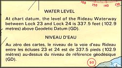 |
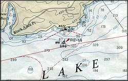
Chart Datum
These notices are printed on the hydrographic charts to indicate the water levels used for chart datum
From Chart 1512, Sheet 3, published by the Canadian Hydrographic Service, 1992. |
Since the Rideau is a controlled system, another factor comes into play, the Parks Canada “rule curves”. Given that enough water comes into the system to replenish the minimum required water flow and losses due to evaporation, Parks can control the level in each section of the Rideau to within a few centimetres by the use of their weirs. To guide them in this, they have set up rule curves for each section of the Rideau, levels which the water should not rise above, or fall below. In most sections, the lower side of the rule curve during navigation season is chart datum. The high end of the rule curve is usually 10 to 20 centimetres above chart datum. Once the canal is closed to navigation, water levels are dropped below chart datum in advance of spring, to accommodate spring runoff and prevent flooding.
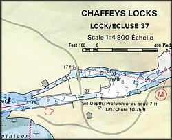 |
Sill Depth
A lock inset showing a sill depth at chart datum of 7 feet.
From Chart 1513, Sheet 3, published by the Canadian Hydrographic Service, 1996. |
Parks tries to maintain at least 6 to 7 feet (1.8 to 2.1 m) of water, at rule curve median, within the navigation channels. This is done by controlling water flow through the weirs and by dredging shallow areas. One factor beyond their control (outside of the weather) is the depth of the lock sills that were established when the locks were built. However Colonel John By was a sharp engineer and even though he didn’t have a 100 years of data to work with, his astute guesses in the late 1820s regarding low water levels on the Rideau, and the design of his slackwater system, provides 6 to 8 feet of water over the sills at current 2002 chart datum. To see this, look at the lockstation insets on your charts and they will indicate the depth to the sill from chart datum (i.e. at low water)
It should be noted that even during the very dry summers of 1999 and 2001, we never went below 5 feet of water in the marked navigation channels. So the water control system that Parks Canada uses works very well.
A Bit of Geography and History
The Rideau Waterway is supplied by two watersheds. The Cataraqui watershed extends from Newboro, south to Lake Ontario. The Rideau Valley watershed extends from Newboro, north to the Ottawa River. On the Rideau, the height of land separating these two watersheds was known as The Isthmus and it caused Colonel By and his workers much grief trying to dig a channel through the solid rock that separated the two watersheds. Although the canal now connects the two watersheds, the only water from the Rideau watershed that goes into the Cataraqui is what is locked though at Newboro, there is no weir that would allow Rideau waters to flow into the Cataraqui.
When the canal was built the lands surrounding the canal were heavily forested and there were many areas of marshland. These forests and marshes acted as a reservoir to the Rideau, allowing any rainfall within the watersheds to slowly percolate back to the waterway over the following weeks or months. As agriculture and lumbering increased in the region, forests were cut down and mashes were drained. This had a significant negative impact on the Rideau, allowing water levels during dry summers to drop to levels dangerous to navigation.
To remedy this problem, a series of reservoir lakes were established. There were existing lakes that were dammed, often increasing their natural water levels. During the summer, if additional water was needed in the Rideau waterway, it would be taken from these reservoir lakes. In the Cataraqui section of the waterway, the principle reservoir lakes are Canoe, Kingsford, Devil, Buck and Loughborough. In the Rideau section of the waterway the reservoir lakes are Wolfe and Bobs. If you happened to live on one of these reservoir lakes you will know it since the allowed draw down can be as much as 2 metres.
Just to add another level of complexity to Rideau water level control, someone discovered electricity and then they invented the hydroelectric dam. Accordingly dams were built along the Rideau Waterway at places such as Kingston Mills, Brewers Mills, Jones Falls, Smiths Falls, Merrickville and Ottawa to take advantage of the water power. These dams lease water rights from Parks Canada. As with most areas in Canada, water levels required for safe navigation take precedence over any other water use, including hydroelectric.
The Weather
Possibly THE most popular topic among Canadians is the weather. What it did yesterday, what it’s doing right now, what it’s going to do tomorrow and the ever popular “I remember when …..”. We have a wonderful government weather service in Canada, part of Environment Canada, and they do a great job providing forecasts and other weather related services.
One such service is the long range forecast. A peek at this year’s long range forecast for June, July and August reveals that for the Rideau region we can expect above average levels of precipitation. So, that should mean no water control issues this summer on the Rideau, we should have lots of water. But (and there’s always a but), Environment Canada also has reviewed the statistical accuracy of their predictions and for this region their accuracy is “not significantly better than chance”, in other words, your guess is as good as theirs.
An advantage that the Rideau has over the Great Lakes is the small size of our watershed and low outflow rate. This means that a couple of weeks of good rainfall can replenish water levels in the Rideau. So, while the Great Lakes may take years to recover from drought, the Rideau can do it in comparatively short order. I have requested information from Parks Canada about watershed size and flow rates and this will be the basis of an upcoming article.
This Summer
This will be a great summer for boating on the Rideau. We’ve got lots of water so grab your charts and head out for a cruise.
- Ken Watson
For more information about "Rule Curves" have a look at:
Parks Canada's Rideau Rule Curves.
|