|
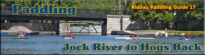
Paddling the Rideau River from
the Jock River to Hogs Back
This is an easy paddling river section of the Rideau River from the Jock River (just north of the Long Island Locks) to the Hogs Back Locks. The map included in this guide can be enlarged (while viewing the PDF) to any level of detail you desire as an aid for travel planning.
You can view or download the PDF file:
| (Clicking this link will open the PDF. You can also just right mouse click the above link and use "Save Target As" to send the PDF directly to your computer.) |

Water Access
There are several points of water access. At the south end is Jock River Landing (45° 15.625'N - 75° 42.480'W), a small park at the mouth of the Jock River, just off Lodge Rd. near the intersection with County Rd. 73 (Prince of Wales Drive). In the middle, there is the ramp in Eccolands Park (45° 18.890'N - 75° 41.830'W) on the east side of the river and the Black Rapids Lock on the west side of the river. At the north end there is the ramp in Mooneys Bay Park (45° 22.190'N - 75° 41.740'W).
Facilities
Lodging: If you're paddling and camping, the lockstations are a good choice for camp spots (a camping fee applies). Camping is allowed at all lockstations except for Ottawa and Smiths Falls Combined. There are a few B&Bs in the general area, plus a host of accommodations in Ottawa. For information about local accommodations see: www.ottawatourism.ca and www.rideau-info.com (this website).
Supplies: A local source for supplies is the city of Ottawa (and the many suburbs).
Big Boats
You'll be sharing the Rideau with big power boats (cruisers). The Rideau is generally not a crowded waterway and often you'll find the large boats in "packs" - travelling from lock to lock - once they pass by you won't see any for awhile. Some of these boats can generate a large wave. The general rule for a paddler and large waves is to meet them head on, this can actually be fun in a kayak (not as much fun in a canoe).
The main navigation channel is shown on the map as a blue dashed line - this is where the big boats will be travelling. So, if you wish to avoid these, pick a route away from the navigation channel. Many paddlers prefer paddling near shore, it's more interesting (i.e. wildlife, cottages) and it keeps you farther away from the waves produced by big boats.
There are several "no wake" zones on the Rideau - these have been marked on the maps. Boaters within these areas are supposed to be travelling at a slow enough speed (less than 10 kph) that their boat doesn't generate any potentially damaging or dangerous waves.
Wind
A question often asked is which way does the wind blow? The prevailing wind, powered by the jet stream, is from the southwest. That's about the only rule of thumb. If a front is moving in then the wind can come from any direction. I've been on several paddles where I've been paddling into the wind on the way out in the morning and into the wind on the way back in the afternoon because the wind swung around 180 degrees (for some reason it never seems to work the other way around - at your back both ways). So, if you're going to travel the entire Rideau, going from Kingston to Ottawa improves the odds of having the wind at your back - but be prepared for anything.
Etiquette
Your trip planning should include a "leave no trace" approach - carry out what you carry in. Many areas are un-serviced (no garbage cans) - so plan to be self-contained. The lockstations provide waste disposal facilities.
Preparation & Safety
Please read the trip planning information on www.rideau-info.com/canal/paddling/. While these lakes are easy paddling, normal paddling preparations should be made (all required safety gear, maps, food, water, first-aid kit, etc.). Zebra mussels are present in many areas along the Rideau, so a pair of water shoes (to avoid cut feet) is recommended.
Please take all normal safety precautions, including checking the weather forecast before you head out and making sure that someone on shore knows your planned travel route and itinerary.
Navigation
While the Rideau is generally easy to navigate, taking along a set of maps is a must (in addition to any GPS you might have). Although the map in this guide is an accurate 1:50,000 representation of the waterway (when printed to 8.5" x 11"), you may also wish to also have the 1:20,000 hydrographic chart for this section (Chart 1513). For power boat navigation, the charts are an absolute must (the map in this guide should not be used for power boat navigation). The charts are also very handy for the paddler, since they show the Rideau in great detail, including depths (which can be helpful when looking for wildlife habitat or just interesting places to paddle).
The charts also show all the navigation buoys. These are all numbered (red buoys have even numbers, green buoys have odd numbers) and so can be used as an aid in locating yourself on the map when you're on open water. A subset of those buoy numbers have been included on the paddling guide maps.
For those wishing to go off the beaten path or want to know more of the topography and geographic features of the surrounding countryside, the 1:50,000 NTS map for this section is 31G/5.
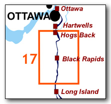
Distances:
Circumference distances are approximate, following the main shorelines. The navigation channel is shown on the map.
- Long Island Locks to Hogs Back Locks = 14.9 km (9.3 mi)
- Jock River Landing to Black Rapids Lock = 7.3 km (4.5 mi)
- Black Rapids Lock to Hogs Back Lock = 6.6 km (4.1 mi))
The Rideau River
The Rideau River is generally a slow moving river, the only appreciable currents will be from the outflow of the canal weirs during times of high water. The main hazard are these same weirs, some with overflow dams. These are well marked on the upstream side and paddlers should avoid getting too close to these. Zebra mussels are present. Aquatic vegetation growth is present in most sheltered areas with a depth of less than 10 ft (3 m). Wildlife is abundant - see Wildlife Viewing in the PDF.
Jock River to Hogs Back
In the pre-canal era, the river was a few feet lower than it is today, water levels have been raised by the canal dam at Hogs Back (which raised the water by 41 feet / 12.5 m at that location).
Although you're now paddling through an area of high urban development, you'll find a surprising amount of natural shoreline. For instance, the section for 2 km south of Black Rapids is where Ottawa's Greenbelt (an area theoretically to remain undeveloped) crosses the Rideau River. You will also find several community parks bordering the Rideau. I've only marked a few of these on the map, ones that appear to offer a landing (and leg stretching) opportunity for the paddler.
One cautionary note, the lower Jock River is not recommended for the paddler-- it can have rough water in the spring and the weir a little ways up has dangerous undertows.
The Locks
Most Rideau lockstations offer facilities such as washrooms, water, recycling cans, waste cans and picnic tables. Most also allow camping for paddlers travelling the Rideau for a modest camping fee. Paddlers can portage the locks for free, but you owe it to yourself to lock through at least one lock in order to get the full experience of paddling the Rideau Canal. See www.rideau-info.com/canal/fees.html for the current fee schedule.
Points of Interest (listed south to north)
Jock River: This 72 km long river was originally known as "River Jacques" (1816). It took on the name "Goodwood River" for a time (1823) and then in 1830 settled on the present name as the Jock River. John Mactaggart speculated in 1827 of making it navigable to Richmond, but no action was ever taken on this idea. The lower Jock River is not recommended for paddlers.
Jock River Landing: This is a small municipal park with road access off of Lodge Road. It's also an easy to use put in / pull out spot for canoes and kayaks.
Vimy Memorial Bridge (formerly the Strandherd-Armstrong Bridge): This is a new bridge crossing of the Rideau Canal, opened in July 2014. It is a fixed high level bridge which has a clearance of at least 6.7 m / 22 ft.
Chapman Mills Conservation Area: This conservation area features 1.5 km of walking trails, washrooms and picnic areas.
Eccolands Park: This public park is an easy spot to get out and stretch your legs. Part of it is located on the site of the quarry used for the stones to build the lock and dam at Black Rapids (the quarry is not visible today).
Black Rapids Lock: This is a single lock with a lift of 9.4 feet (2.8 m). It's one of the most "modernized" locks on the Rideau Canal with almost every feature, including the lock itself, having been rebuilt over the years. The dam was fully rebuilt in 1949-50. The weir was rebuilt in 1925. The lock was rebuilt with concrete blocks in 1928. The original stone lockmaster's house was replaced by a frame house in 1914. The most significant change was the electrification of the lock in 1969.
The original dam in this location was a stone arch dam (an example of this is the dam that presently exists at Nicholsons). However, it was subject to ice and spring flooding damage. Repairs included adding (1841) a timber apron below the dam (to prevent erosion) and then capping (1862) it with a timber flat dam (essentially using the stone dam as a foundation). That was replaced in 1906 and 1909. In 1949-50, the straight concrete dam that you can see today was built just downstream of the original arch dam. Parts of the original arch dam still exist underwater.
The lockstation property is very pretty with nice lawns and large shade trees - it's a good spot to take a break or to camp.
Ottawa MacDonald-Cartier International Airport: In the area of Black Rapids you'll likely hear or see airplanes. To the east is the Ottawa Macdonald-Cartier International Airport. It started as a civilian flying field as early as 1919 (Hunt Club Field) and then a more formalized flying club airport (Uplands - named due to the upland plateau it was built on), then was used by the military during WWII (training facility), then became a joint civilian/military facility and finally a full civilian facility.
Michael J.E. Sheflin (Hunt Club) Bridge: This is a fixed high level (>16 m / >50 ft) concrete bridge built in 1985. It carries Hunt Club Road across the canal. It was rehabilitated/expanded in 2006.
Whale Bones: just a bit north of the airport (a bit north of Hunt Club Bridge), the 10,420 year old (+/- 150 yrs) bone of a Beluga/White whale (Delphinapterus leucas) was found. At that time, this area was under the Champlain Sea, a brackish water sea created by the retreating glaciers (see Geology section).
CNOR Railway Bridge: This is a fixed high level (9.5 m / 30.8 ft) railway bridge. The bridge was originally built for the Canadian Northern Ontario Railway in 1913. It is owned today by the Canadian National Railway.
Captain Wilson – Ossian Hall: about 175 m north of the CNOR bridge, on the east shore, is the former location of Captain Andrew Wilson's property. Wilson, a retired royal navy officer, arrived in the Ottawa area in 1819 and built a large log building which he named Ossian Hall. The section of the Rideau River in this location was known as “Captain Wilson’s Still Water” – a slow moving section of the river located to the south of a major set of rapids, Three Island Rapids, now drowned under the head of Mooney’s Bay. The 1827 lockstation investigative surveys of the Rideau route all started from this location (to avoid all the rapids between here and the Ottawa River), with canoes portaged from the Ottawa River to this location and supplies for the trip arriving by cart along a crude road to Ossian Hall.
Wilson left in 1829 and the building was purchased by Margaret & Daniel O’Conner, who lived there for many years.
Mooneys Bay: As you come to the curve of the river at the head of Mooneys Bay, you'll be paddling over the drowned Three Island Rapids, one of two sets of rapids in this area that gave raftsmen (floating timber down the Rideau River) trouble before the canal was built (the second set of rapids was Three Rock Rapids - see Hogs Back).
Mooneys Bay Park: A public park with a large public beach, a good spot to stop and have a picnic and/or a swim.
Rideau Canoe Club: Just above the locks on the west shore you'll find the Rideau Canoe Club. So you may find many other paddlers in this area, generally paddling racing canoes and kayaks.
Rideau River to Ottawa River: The Hogs Back Dam marks the end of the Rideau Canal portion of the Rideau River. Water flowing through the weir continues along the original channel of the Rideau River to the twin Rideau Falls, where the river plunges 30 feet (9 m) to the Ottawa River. Passing through the locks at Hogs Back drops you into the artificial cut that leads to the Ottawa Locks.
Hogs Back Locks: This is a set of two locks, a lift lock and a guard lock. The guard lock was built as a flood prevention mechanism and normally only the lift lock (northern lock) is used. It has a lift of 13.8 feet (4.2 m).
This area is the most spectacular example of landscape change brought about by the building of the Rideau Canal. This was the spot chosen to have the canal leave the Rideau River, the location known originally as Three Rock Rapids. These rapids had a drop of 6 feet (1.8 m) over a length of 2,000 feet (600 m). According to John Mactaggart (1829) it is "called the Hog's Back, from the circumstance of raftsmen with their wares [timber] sticking on it in coming down the stream" (the rocks sticking up appeared in form of the bony back of a hog).
Lt. Colonel John By decided to build a large dam here in order to flood the river all the way up to the foot of the lock he planned to build at Black Rapids. This big dam would also put a head of water into the canal cut leading to the Ottawa locks. But he had lots of trouble - the dam fell down (washed away) three times during construction and in the end a new engineering technique had to be employed to create the dam that stands to this day (this story is recounted in Tales of the Rideau). The dam raised the water by 41 ft (12.5 m) in this location.
The dam itself is difficult to see, it is the section of land between the locks and the weir. Hogs Back Road runs along the top of it. Although it started off as a stone dam which would have been similar to the large dams seen at places such as Long Island Lockstation and Jones Falls Lockstation, it is the stone dam that fell down three times. In the end, timber cribbing filled with broken stone was used to dam the Rideau River. Earthen material forms the apron (front) of the dam and rubble stone the back. You can see a large amount of that rubble stone backing near the weir.
Hogs Back Falls: Take a short walk to view the present day falls (technically the "Prince of Wales Falls" but known locally as the "Hogs Back Falls"), located just downstream from the waste water weir. What you're seeing is not a natural waterfall, it's the 12.5 m /41 ft of dam-raised water going through a man-made (excavated) channel, heading back to the original level of the Rideau River. If you want to get a sense of what the Three Rock Rapids looked like, the lower half of those rapids still exist below the dam and present day falls.
The rapids here were formed by several small faults, tilting and fracturing the rock units. The fault disruption of those rock units can be clearly seen today. The rocks are mostly made up of Ottawa Limestone (a quarry in the limestone on the east side of the river was used to obtain the stones used in the locks). You can also see some darker shaly and sandy rocks, part of the older Rockcliffe Formation.
The original rapids didn't require a portage - indigenous peoples, surveyors and voyageurs would line their canoes (pull them) up or down the rapids. It does appear that when those not skilled at those canoeing techniques arrived in the area that a portage was developed to allow them to bypass the rapids. There is a tale told of the Billings family (early settlers) accidently shooting the rapids (c.1814). The problem with the tale is that it has the Billings going over the falls, which didn't exist until the dam was built. Nonetheless, if you look at the rapids below the falls, you can imagine the poor Billings family shooting through that in a canoe.
Geology
As you paddle the Rideau Canal, the route you follow is defined by its geology. Geological highlights have been included in the Points of Interest listings and a general geological history of the route can be found on the Geology of the Rideau Page.
Wildlife Viewing
A section about wildlife viewing, what you might expect to see on your Rideau journey, has been included in text form in the PDF. A version of this information, that includes photos of some typical Rideau wildlife, can be found on the Fauna of the Rideau Page (in the ecology section of this website).
Errors
If you find any errors or omissions in this guide, please let me know (rideauken@gmail.com) and I'll get them fixed.
Terms of use
This guide may be freely used for personal purposes. Have fun on your Rideau paddling adventure.
Commercial use is not allowed in whole or in part without express written permission.
©2010- Ken W. Watson, All Rights Reserved.
You can view or download the PDF file:
| (Clicking this link will open the PDF. You can also just right mouse click the above link and use "Save Target As" to send the PDF directly to your computer.) |
|