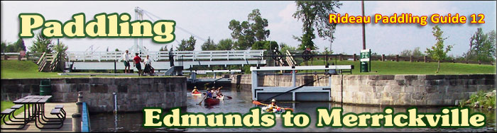
Paddling the Rideau River
from Edmunds to Merrickville
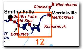
This is an easy paddling river section of the Rideau River, with lots of marshland bordering the river in this area. The map included in this guide can be enlarged (while viewing the PDF) to any level of detail you desire as an aid for travel planning.
You can view or download the PDF file:
| (Clicking this link will open the PDF. You can also just right mouse click the above link and use "Save Target As" to send the PDF directly to your computer.) |

Water Access
Water access is available at Edmunds Lock, Kilmarnock Lock and at Merrickville. For the paddler the easiest is either Edmunds (ramp - 44° 52.600'N - 75° 59.020'W), Kilmarnock (shoreline - 44° 53.060'N - 75° 55.820'W), or the canoe launch in Merrickville (44° 55.980'N - 75° 50.690'W - on the rec centre grounds, just past the public library). All of these spots offer plenty of parking. Another option in Merrickville is the ramp in the Lions Park Campground (44° 55.020'N - 75° 50.580'W).
Facilities
Lodging: If you're paddling and camping, the lockstations are a good choice for camp spots (a camping fee applies). There is also the Lions Park Campground in Merrickville, a host of B&Bs and several hotels (Merrickville and Smiths Falls). For information about local accommodations see: For information about local accommodations see: www.smithsfalls.ca and www.rideau-info.com (this website).
Supplies: A local source for supplies is the town of Smiths Falls which has which full facilities (grocery stores, pharmacies, hardware stores).
Big Boats
You'll be sharing the Rideau with big power boats (cruisers). The Rideau is generally not a crowded waterway and often you'll find the large boats in "packs" - travelling from lock to lock - once they pass by you won't see any for awhile. Some of these boats can generate a large wave. The general rule for a paddler and large waves is to meet them head on, this can actually be fun in a kayak (not as much fun in a canoe).
The main navigation channel is shown on the map as a blue dashed line - this is where the big boats will be travelling. So, if you wish to avoid these, pick a route away from the navigation channel. Many paddlers prefer paddling near shore, it's more interesting (i.e. wildlife, cottages) and it keeps you farther away from the waves produced by big boats.
There are several "no wake" zones on the Rideau - these have been marked on the maps. Boaters within these areas are supposed to be travelling at a slow enough speed (less than 10 kph) that their boat doesn't generate any potentially damaging or dangerous waves.
Wind
A question often asked is which way does the wind blow? The prevailing wind, powered by the jet stream, is from the southwest. That's about the only rule of thumb. If a front is moving in then the wind can come from any direction. I've been on several paddles where I've been paddling into the wind on the way out in the morning and into the wind on the way back in the afternoon because the wind swung around 180 degrees (for some reason it never seems to work the other way around - at your back both ways). So, if you're going to travel the entire Rideau, going from Kingston to Ottawa improves the odds of having the wind at your back - but be prepared for anything.
Etiquette
Your trip planning should include a "leave no trace" approach - carry out what you carry in. Many areas are un-serviced (no garbage cans) - so plan to be self-contained. The lockstations provide waste disposal facilities.
Preparation & Safety
Please read the trip planning information on www.rideau-info.com/canal/paddling/. While these lakes are easy paddling, normal paddling preparations should be made (all required safety gear, maps, food, water, first-aid kit, etc.). Zebra mussels are present in many areas along the Rideau, so a pair of water shoes (to avoid cut feet) is recommended.
Please take all normal safety precautions, including checking the weather forecast before you head out and making sure that someone on shore knows your planned travel route and itinerary.
Navigation
While the Rideau is generally easy to navigate, taking along a set of maps is a must (in addition to any GPS you might have). Although the map in this guide is an accurate 1:50,000 representation of the waterway (when printed to 8.5" x 11"), you may also wish to also have the 1:20,000 hydrographic chart for this section (Chart 1513). For power boat navigation, the charts are an absolute must (the map in this guide should not be used for power boat navigation). The charts are also very handy for the paddler, since they show the Rideau in great detail, including depths (which can be helpful when looking for wildlife habitat or just interesting places to paddle).
The charts also show all the navigation buoys. These are all numbered (red buoys have even numbers, green buoys have odd numbers) and so can be used as an aid in locating yourself on the map when you're on open water. A subset of those buoy numbers have been included on the paddling guide maps.
For those wishing to go off the beaten path or want to know more of the topography and geographic features of the surrounding countryside, the 1:50,000 NTS map for this section is 31B/13.
Distances:
Circumference distances are approximate, following the main shorelines. The navigation channel is shown on the map.
- Edmunds Lock to Kilmarnock Lock along the navigation channel = 6.0 km (3.7 mi)
- Kilmarnock Lock to Merrickville Locks along the navigation channel = 12.5 km (7.8 mi)
- Edmunds Lock to Merrickville Locks along the navigation channel = 18.5 km (11.5 mi)
- Edmunds to Kilmanock - shoreline circumference = 14 km (8.7 mi)
- Kilmarnock to Merrickville - shoreline circumference = 36 km (22.5 mi)
The Rideau River
The Rideau River is generally a slow moving river, the only appreciable currents will be from the outflow of the canal weirs during times of high water. The main hazard are these same weirs, some of which have overflow dams. These are well marked on the upstream side and paddlers should avoid getting too close to these. Zebra mussels are present. Aquatic vegetation growth is present in most sheltered areas with a depth of less than 10 ft (3 m).
Edmunds Lock to Kilmarnock Lock
In the pre-canal era, the river was about 2 ft (0.6 m) lower than it is today at the foot of Edmunds, and about 6 ft (1.8 m) lower at the head of Kilmarnock. The completion of the lock and weir at Maitland's Rapids (today's Kilmarnock) in the fall of 1831 raised the water in the river to the level it is today.
The river channel has a maximum depth of 10 ft (3 m). The water depth outside of the marked channel averages about 4 ft (1.2 m). The land bordering the river is all privately owned except for the federal lands at the lockstations. There is little cottage/home development in this section, just a few spots where there is road access to non-marshland shorelines.
Kilmarnock Lock to Merrickville
In the pre-canal era, the river was about 3.5 ft (1.1 m) lower than it is today at the foot of Kilmarnock, and about 6 to 8 ft (2 to 2.5 m) lower at the head of Merrickville. The completion of the lock and weir at Merrickville in 1831 raised the water in the river to the level it is today.
The river channel has a maximum depth of 15 ft (4.6 m). The water depth outside of the marked channel averages about 4 ft (1.2 m). The land bordering the river is all privately owned except for the federal lands at the lockstations. There is only a few spots with cottage/home development in this section, locations where there is road access to non-marshland shorelines.
The Locks
Most Rideau lockstations offer facilities such as washrooms, water, recycling cans, waste cans and picnic tables. Most also allow camping for paddlers travelling the Rideau for a modest camping fee. Paddlers can portage the locks for free, but you owe it to yourself to lock through at least one lock in order to get the full experience of paddling the Rideau Canal. See www.rideau-info.com/canal/fees.html for the current fee schedule.
Points of Interest (listed south to north)
Edmunds Lock: This lockstation has a single lock, a weir and an overflow dam. The lock has a lift of 9.2 ft (2.8 m). A two-storey lockmaster's house is located on site (the lockstation office today). It was built in 1905, replacing an earlier stone defensible lockmaster's house that had been built here in the 1840s. Edmunds, accessed by road from County Road 17 (south side of the Rideau River) features extensive grounds (verdant lawns with large shade trees), lots of parking, and a boat launch.
This lockstation features a stone arch overflow dam. Originally, all of the dams designed by Colonel By and the other Royal Engineers were to be overflow dams (including the largest, the huge dam at Jones Falls). But, after seeing the effect of spring flooding, By quickly changed his plans, making many into non-overflow dams and adding waste-water weirs to all of them. In the case of Edmunds we have a combination of both - an overflow dam with a waste-water weir. He explained the weir in an 1830 report noting "the addition of a Waste Weir to preserve the Dam from the effects of Spring Floods." The dam has been doing a great job, it's only required normal maintenance. The weir was rebuilt in 1906-07.
Edmunds or Edmonds? The lock is named after James Edmunds, the first settler in this area. Over the years his name has been spelled Edmunds, Edmonds and even Edmons. Currently Parks Canada used Edmonds and the Canadian Hydrographic Service (charts) uses Edmunds. Either is fine. At one point this lock was known as Mills Lock (named after the first two Lockmasters, Edward Mills and his son William W. Mills), removing the issue of how to spell Edmunds.
Rideau River - Edmunds to Kilmarnock: This peaceful section of the Rideau River provides lots of wildlife viewing opportunities along the marshy borders of the river.
Kilmarnock Lock: This lockstation has a single lock and a weir. It has the lowest lift of any lockstation on the Rideau at only 0.7 m (2.2 ft). It also has one of only four remaining unequal arm, center-bearing timber swing bridges on the Rideau. It has a two storey lockmaster's house, used today as the lockstation office.
The low lift is due to many difficulties encountered during construction. A significant problem was the boulder filled mud in the original location for the lock. The boulders were very difficult to remove with the technology of the day, as Colonel By noted "more difficult from their hard Nature to remove than Solid Rock." So, he knocked two feet off the original height of the dam and lock, moved the location of the lock to where bedrock had been found and excavated a channel into the head of the lock (this channel was deepened in 1900).
The lockmaster's house started off as a defensible one-storey house, built in the 1840s. In the early 20th century, a second storey was added and the loopholes in the original building were filled in.
The original name for this lock was Maitland's Lock (named after the location, Maitland's Rapids). The name Maitland comes from an early settler in the area, James Maitland, who operated a ferry across the river in this location. Maitland also became the first lockmaster (from 1832 to 1846). Over time, the local name, Kilmarnock, came into general use.
Rideau River - Kilmarnock to Merrickville: Extensive marshlands, including the Big Marsh, affords marshland wildlife viewing opportunities. The river also passes by the outlet of Irish Creek, once considered as a route for the Rideau Canal (see below).
Irish Creek: This creek has its origins in Irish Lake. The building of the canal flooded the creek up to Jasper. In his 1816 survey of the Rideau Route, Lt. Joshua Jebb of the Royal Engineers recommended that the route be taken by way of Irish Creek rather than through the Rideau lakes. The canal would have gone up the creek to Irish Lake where a five mile long railroad was proposed to link the route to Upper Beverley Lake and from there to Lower Beverley Lake and up Morton Creek to re-join the present-day route of the Rideau Canal. The Irish Creek route was discounted by the next survey, that of Samuel Clowes in 1823/24. Clowes pointed out two flaws with the route, it wasn't any lower than a route by the Rideau lakes (and so would require the same number of locks) and the top of the route had no water (unlike the Rideau lakes route, where the top of the route is a lake). For a paddle description, see Irish Creek in the Off the Beaten Path section.
Big Marsh: This marshy area offers some very good bird viewing opportunities. It actually provides a larger marshy area for wildlife viewing than the Rideau Bird Sanctuary.
Rideau Bird Sanctuary: This is a designated Canadian Migratory Bird Sanctuary, some 800 ha in size. The designation primarily means no hunting within the sanctuary (there are no restrictions on development). This area is used as a staging area in spring and summer for migratory waterfowl. The wetlands bordering the Rideau River in this area provide a good food source for these migrating birds. A total of 20 different species of geese and ducks have been observed using the sanctuary. You may also see wetland mammals such as muskrats, beavers and otters in the sanctuary. A word of caution is that there are submerged stumps in parts of this area (the children of a local paddler refer to parts of the RBS as "stumpland").
Merrickville Locks: There are three detached locks at this location (total lift of 7.6 m / 25.0 ft). The lockstation office is located adjacent to the middle lock. The largest blockhouse on the Rideau Canal is located beside the upper lock. The locks are spread out as three separate locks in order to take advantage of the topography, if they had been built as three locks "in-flight" (combined) it would have required much more excavation and/or embanking.
The original water control dam was at the head of the canal cut (see Depot to Dam Trail below). A stone dam extended partway across the river with a timber/gravel dam and waste water weir placed in the main channel. It was placed in this location to avoid interfering with the mills, which had their own dam (at or near the location of the present day dam and roadway). With the canal dam upstream in this location, the water level of the Rideau River going into the canal cut could be controlled, with most of the flow of the river going unhindered to the mills.
However, the timber construction of the weir led to all sorts of trouble and it wasn't strong enough to withstand high water flows. It was swept away in 1841 and rebuilt somewhat stronger. However, that threatened to give away in 1847 and only with the help of many residents of the town were the dam and weir saved. It was damaged again in 1862 but survived. In 1912, the position of the weir was relocated to where it is today, in alignment with the upper lock. The original weir was removed, leaving just the stone portion of the dam.
The first bridge was a rolling bridge positioned across the upper lock. It was replaced by a timber swing bridge, also across the lock, in 1843. In 1892 a steel bridge was installed on a new alignment, just below the upper lock (so that small boats could pass in and out of the lock without having to swing the bridge). The current electric swing bridge was installed in 1990.
Merrickville Blockhouse: This is the largest blockhouse on the Rideau Canal. It is open to the public during the summer season, operated by the Merrickville and District Historical Society. The grassy picnic area beside the upper lock is known as Blockhouse Park. The blockhouse was built in 1832 to help defend this critical spot (near the road to the St. Lawrence River, a likely route for American invasion forces). The building served as a home to the early lockmasters, although by the 1870s it was starting to deteriorate. The resident at the time, Lockmaster Matthew Johnson noted that "The building generally is minus of its original evenness." The foundations were sinking and the roof had separated from its support posts. In 1909, the second floor, which at the time was made of masonry, had to be removed. The government was ready to tear the building down in the early 1960s, but fortunately heritage prevailed and the building was rehabilitated in 1962-65. For more info see: www.merrickvillehistory.org
The Depot: This is the summer home of Friends of the Rideau, who operate it as a visitor centre and retail outlet (including the sale of many books about the heritage of the Rideau). The building dates to about 1857, originally built as a storehouse with a wharf in front of it. For more info see: www.rideaufriends.com
Merrickville: This very pretty village is filled with various artisan shops and stores that cater to visitors. It is located at the site of the "Great Falls" - a waterfall (4.2 m / 14 ft) in the Rideau River. In about 1790, this water power attracted a miller, Roger Stevens, to set up a sawmill here (he had settled in a spot a bit downstream from this location in 1789). By 1793, the year that he died of drowning, he had apparently sold it to William Mirick. William continued to develop the site and by the early 1800s, a small community, known as Mirickville (later Merrickville) was developing. The coming of the Rideau Canal allowed Merrickville to become a full-fledged village. The Rideau River continued to power a series of mills, foundries and factories through the 19th century. A heritage walking tour brochure of the town can be found at several locations and on-line.
Industrial Heritage Complex: Located on what was an island between the original channel of the Rideau River and a flood channel of the river, this area housed several stone buildings, which included at various times a grist mill, a woollen mill, an oatmeal mill, a sawmill and a foundry. Today, only ruins remain of these buildings. In the old foundry you'll find many interpretive displays created and maintained by Parks Canada.
Depot to Dam Trail: This is a trail that leads from The Depot, across the upper lock and then south, to the entrance of the canal cut. The path then goes along the top of the stone dam (the original canal dam) that extends from the canal cut to the original channel of the Rideau River. An interpretive brochure for the trail is available at The Depot (also available on-line).
Off The Beaten Path
Irish Creek
Once considered as a potential route for the Rideau Canal, this is a slow moving meandering creek. The total distance from Roses Bridge (at the outlet of the creek into the Rideau River) to Irish Lake is 16.4 km (10.2 mi). The distance from that bridge (44° 51.490'N - 75° 54.860'W) to Jasper is 4.4 km (2.7 mi). This is a section flooded from the canal dam at Merrickville and features large areas of marsh and lily pads. If you want to launch right into Irish Creek, you can use the small gravel launch at Roses Creek Bridge (44° 51.490'N - 75° 54.890'W).
At Jasper, you'll find a very low concrete bridge. Depending on water levels, you should be able to slip a canoe or kayak under the bridge (remember to duck). The distance from Jasper (44° 50.015'N - 75° 55.900'W) to Irish Lake is 12.0 km (7.5 mi). The creek may be dammed in places by beavers, a few years ago I encountered the first beaver dam 2.5 km (1.5 mi) upstream from Jasper.
Geology
As you paddle the Rideau Canal, the route you follow is defined by its geology. Geological highlights have been included in the Points of Interest listings and a general geological history of the route can be found on the Geology of the Rideau Page.
Wildlife Viewing
A section about wildlife viewing, what you might expect to see on your Rideau journey, has been included in text form in the PDF. A version of this information, that includes photos of some typical Rideau wildlife, can be found on the Fauna of the Rideau Page (in the ecology section of this website).
Errors
If you find any errors or omissions in this guide, please let me know (rideauken@gmail.com) and I'll get them fixed.
Terms of use
This guide may be freely used for personal purposes. Have fun on your Rideau paddling adventure.
Commercial use is not allowed in whole or in part without express written permission.
©2021 Ken W. Watson, All Rights Reserved.
You can view or download the PDF file:
| (Clicking this link will open the PDF. You can also just right mouse click the above link and use "Save Target As" to send the PDF directly to your computer.) |
|