Your location: Rideau Canal Home Page > Rideau Lockstations > Davis Lock 38
| Number of locks: 1 |
Total Lift: 2.7m ( 9 ft.) |
Lock Through Time: 15 min.* |
| Chart No: 1513 (Sheet 3) |
GPS:1 N 44° 33.775' W 76° 17.530' |
| Chart Sales: No |
Lockstation Tel: 613-359-5620 |
| Washrooms: Yes2 |
Drinking Water: Yes3 |
Day Use Docking: Yes |
| Overnight Mooring: Yes |
Docking4 Upstream: 140m/460' |
Docking4 Downstream: 43m/140' |
| Ice: No |
Power**: Yes (U) |
Boater Camping:5 Yes |
| Boat Launch: No |
Picnic Tables: Yes |
BBQ Grills: Yes |
| Parking: Yes |
Public Telephone: No |
Self Guided Trail: No |
Hwy Access: 9 km W of Hwy 15
on Davis Lock Rd. |
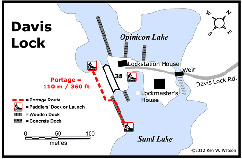
Lock Connects: Sand Lake to Opinicon Lake |
| Civic Address: 1822 Davis Lock Road,
Rideau Lakes, Ontario |
| Special Notes: To ensure passage, boaters must arrive at least 30 minutes prior to closing.
|
| Of Interest: Davis is known as a “solitude lock,” one of the most remote locks on the Rideau. It’s named after Walter Davis Jr. who built a sawmill here in about 1818. It features the best preserved example of a defensible lockmaster’s house on the Rideau. Built in 1842, this stone house served as home to the local lockmaster until 1959. The building was fully restored in 1999. The view, from this house into Sand Lake is, except for the navigation buoys, essentially what Colonel By would have seen when the canal opened in 1832.
|
| Notes: Gas is available at Sand Lake Marine. No local services. Solitude lock. |
|
* Time to actually go through the locks. Allow at least twice this time when trip planning. See Schedule Caveats.
** U = upstream side, D = downstream side
1) GPS data should not be used for navigation. See the GPS page.
2) Washrooms are wheel chair accessible.
3) Unless indicated otherwise, water at the lockstation is potable.
4) Includes both blueline and greyline docking - see Lockstation Docking Page.
5) Allows tent camping for those arriving by water and also for cyclists and hikers.
|
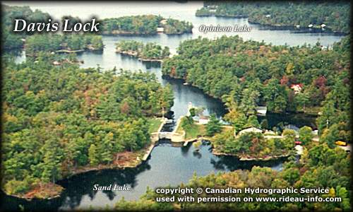 |
Davis Lock looking WestA view of Davis Lock with part of Sand Lake in the foreground and Opinicon Lake in the background. Known as a "solitude lock" Davis lock is located literally at the end of the road.
photo copyright © Canadian Hydrographic Service - used with permission |
Comments: send me email: Ken Watson
©1996- Ken W. Watson
|