Your location: Rideau Canal Home Page > Rideau Lockstations > Lower Beveridges Lock 33
  LOWER BEVERIDGES Lock 33
Number of locks: 1 Total Lift: 3.6m ( 12 ft.) Lock Through Time: 15 min*
Chart No: 1513 (Sheet 1) GPS:1 N 44° 52.500'    W 76° 08.375'
Chart Sales: No Lockstation Tel: 613-267-2036
Washrooms: Yes2 Drinking Water: Yes3 Day Use Docking: Yes
Overnight Mooring: Yes Docking4 Upstream: Note 1 Docking4 Downstream: 191m/625'
Ice: No Power: Yes Boater Camping:5 Yes
Boat Launch: Yes Picnic Tables: Yes BBQ Grills: Yes
Parking: Yes Public Telephone: No Self Guided Trail: No
Hwy Access: just S. of Port
Elmsley Rd. (Cty. Rd.18)
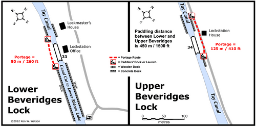
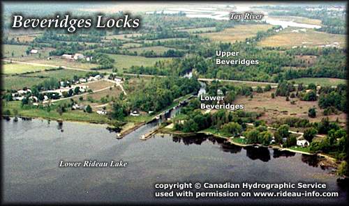
Lock Connects: Lower Rideau Lake to Tay Canal
Civic Address: 145 Beveridges Lock Road, Drummond/North Elmsley, Ontario
Special Notes: To ensure passage, boaters must arrive at least 30 minutes prior to closing.

Of Interest: See notes for Upper Beveridges.
Notes: Closest gas is Rideau Ferry. No local services.
* Time to actually go through the locks. Allow at least twice this time when trip planning. See Schedule Caveats.
1) GPS data should not be used for navigation. See the GPS page.
2) Washrooms are wheel chair accessible.
3) Unless indicated otherwise, water at the lockstation is potable.
4) Includes both blueline and greyline docking - see Lockstation Docking Page.
5) Allows tent camping for those arriving by water and also for cyclists and hikers.
Note 1: 240' of blueline docking between U. and L. Beveridges is available during lock operating hours.

Google Earth View Beveridges Lockstation in Google Earth
(You must already have Google Earth - click here for more info)

Beveridges to Perth Photo Tour Video


Map of Beveridges Lockstation

Beveridges Locks
Beveridges Locks looking Northwest
This lock is at the entrance to the Tay Canal which links the Rideau with the beautiful old Town of Perth. It makes an interesting side trip on your Rideau journey.
photo copyright © Canadian Hydrographic Service - used with permission


Comments: send me email: Ken Watson

©1996- Ken W. Watson