Your location: Rideau Canal Home Page > Rideau Lockstations > Smiths Falls Detached Lock 31
| SMITHS FALLS DETACHED Lock 31 |
|
|
| Number of locks: 1 |
Total Lift: 2.6m ( 8.5 ft.) |
Lock Through Time: 15 min.* |
| Chart No: 1513 (Sheet 1) |
GPS:1 N 44° 53.755' W 76° 01.630' |
| Chart Sales: No |
Lockstation Tel: 613-283-0496 |
| Washrooms: Yes2 |
Drinking Water: Yes3 |
Day Use Docking: Yes |
| Overnight Mooring: Yes |
Docking4 Upstream: 130m/425' |
Docking4 Downstream: 46m/150' |
| Ice: No |
Power: No |
Boater Camping:5 Yes |
| Boat Launch: Yes |
Picnic Tables: Yes |
BBQ Grills: Yes |
| Parking: Yes |
Public Telephone: No |
Self Guided Trail: No |
| Hwy Access: off Lombard St. |
Lock Connects: Rideau River to Rideau River |
| Civic Address: 62 Lombard Street, Smiths Falls, Ontario |
| Special Notes: To ensure passage, boaters must arrive at least 30 minutes prior to closing. The Abbott Street swing bridge has a clearance of 1.9m (6.2 ft). It will swing on demand except from June 18 to August 15 when the following swing times will be in force Monday to Friday; 08:45h, 09:30h, 10:15h, 11:00h, 11:45h. After 13:00h bridge will swing on demand. |
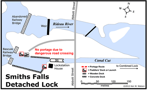
| Of Interest: A distinctive feature of this lock is the rather spectacular, raised bascule bridge. This Scherzer rolling-lift railway bridge was built in 1912-13 and was used until the rail line ceased operation in 1984. Since then it has been permanently kept in the raised position. It was designated a National Historic Site of Canada in 1983. This bridge is a clue that Smiths Falls was a major railway hub. The Smiths Falls Railway Museum is located just up the road from the lock. The start of the Cataraqui Trail (hiking and cycling along the old CN railway line) can be found near the liquor store a little ways down Highway 15. |
| Notes: Closest marina is at Rideau Ferry. The best tie-up is between the detached & combined locks. |
|
* Time to actually go through the locks. Allow at least twice this time when trip planning. See Schedule Caveats.
1) GPS data should not be used for navigation. See the GPS page.
2) Washrooms are wheel chair accessible.
3) Unless indicated otherwise, water at the lockstation is potable.
4) Includes both blueline and greyline docking - see Lockstation Docking Page.
5) Allows tent camping for those arriving by water and also for cyclists and hikers.
|
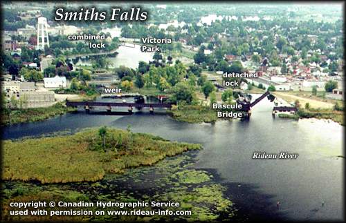 |
Smiths Falls Detached Lock looking EastA landmark as you approach the lock from the west is the Scherzer rolling-lift railway bridge (a type of bascule bridge), now in a permanently raised position. Built in 1914 it is now a Canadian National Historic Site. Once you pass through the detached lock, you will end up in the basin that lies beside Victoria Park, a favourite tie-up spot for boaters.
photo copyright © Canadian Hydrographic Service - used with permission |
Comments: send me email: Ken Watson
©1996- Ken W. Watson
|