ABOUT SEELEYS BAY
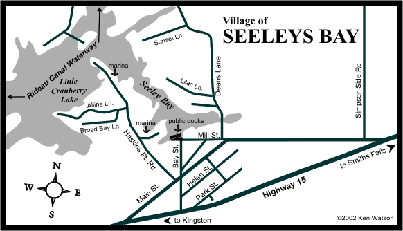
Seeleys Bay is the first full service community, north of Kingston, at the southern end of the Rideau Corridor. Located just off Highway 15, it sits on a bay a few hundred metres off the main navigation channel of the Rideau Canal. The visitor will find lots of accommodation choices within a few kilometres of Seeleys Bay.
Seeleys Bay offers extensive public docking, a boat launch ramp and even a special canoe/kayak launching area. Power is available at the docks and several marinas are located nearby. There is a community park with playground and picnic tables. Supplies, fishing and boating items are available in the village at Main Street Hardware.
Frost Fest, an annual winter carnival, is held in early February.
HISTORY
The flooding of Cranberry Marsh during the building of the Rideau Canal formed the geographic bay which was to become "Seeleys Bay". The dam and locks at Upper Brewers, completed in 1832, and the control dam at Morton raised the water level, flooding the marsh, changing it into today's Cranberry Lake.
The lot on which Seeleys Bay sits was originally granted to Matilda Read. In 1825, her son, John Seeley, acquired the lot. However it was his father, Justus Seeley, with his second wife Anne and their youngest children who moved onto the land that would become the village of Seeleys Bay. After Justus died in 1830, Anne remained on the land.
The site became a landing for steamboats plying the Rideau, and Anne and her children ran a store to serve visitors. In 1841, the community that was growing in area became known as Seely's Bay (sic). By the 1850s, Seely's Bay was a regular stop for stagecoaches heading south to Kingston and north to Perth. In 1950 the spelling was changed to "Seeleys Bay".
For detailed information about the history of Seeleys Bay, read "The Rear of Leeds & Lansdowne, The Making of Community on the Gananoque River Frontier - 1796-1996" by Glenn J Lockwood.
|