How Much of the Rideau Canal is Manmade
by
Ken W. Watson
Note: This article first appeared in the Spring/Summer 2022 edition of Rideau Reflections, the newsletter of the Friends of the Rideau (www.rideaufriends.com).
| |  |
| |
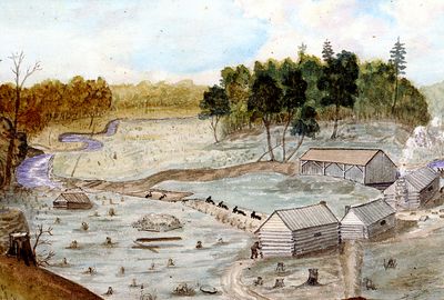
Lower Brewers 1829This painting shows two workers with pickaxes and four with
wheelbarrows, excavating the channel into the lock pit at Lower
Brewers. A bypass channel was excavated here to maintain the
operating sawmill (building in background right). Painting by
Thomas Burrowes, Archives of Ontario, C 1-0-0-0-67.
|
Back in the summer of 2019, I received an email with a simple question: “Is there a map of the Rideau Canal showing which sections are man-made?” The answer at that time was also simple, “no, there is not”. The answer today would be “yes there is” since the question piqued my interest and I set about to create a set of maps showing the man-made sections. But then I hit snag, what exactly is meant by “man-made”? As those familiar with the Rideau Canal know, the 202 km long Rideau Canal is mostly a series of lakes and rivers connected by locks and short canal cuts.
Defining man-made then led to more questions and soon I was writing a book to provide an explanation of the not just the whats and wheres of the man-made work, but also the whys, the whos and the hows. Why did Lt. Col. John By make certain decisions? How exactly did they do it? Who did it? (details of the workforce). I was 136 pages into writing a book on this subject in 2020 when COVID-19 hit and de-railed that project. The book is yet to be completed, but this article will provide the main results.
If you use a broad definition of man-made as “changed from its original natural state” then the answer to the question is 100% since essentially every part of the Rideau is flooded due to the slackwater design of the canal. If you think of it as “excavated channels” then the number is much smaller, but it becomes more complicated. Should we just count visibly excavated sections (what we can see today), or the total amount of excavation, some now flooded over? Since I don’t do things by halves, I ended up with a number of definitions including visible excavations, hidden excavations, channel clearing and apparent excavations (gully clearing). While I was at it, I also wanted to document how much of today’s Rideau Canal was above water in the pre-canal era (dry land), how much was water less than 5 feet deep and how much was water over 5 feet deep (navigation depth). This water depth information was the challenge Lt. Colonel John By faced in making a minimum 5 foot deep navigation way between the Ottawa River and Kingston. In addition, I thought it would be interesting to compare the excavations required for By’s slackwater canal design to Samuel Clowes’ conventional canal design proposal.
The last survey prior to the British government green-lighting the construction of the Rideau Canal in 1826, was done by civilian surveyor Samuel Clowes in 1823 and 1824. Clowes proposed a conventional canal system with excavated channels cut to bypass rapids. When everything is measured up, Clowes’ proposal would have involved 31 kilometres of excavated bypass channels and about 19 km of channel straightening for a total of almost 52 km of excavation work. Clowes’ canal was designed for unpowered vessels; his design included a tow path along most of his canal route.
Lt. Colonel John By was a visionary, he saw that steamboats were the future. The British military was moving to steam as were civilian commercial vessels. These self-powered craft didn’t need a tow path and hence he could use a less costly and faster to build technique, a slackwater design. Slackwater, in its pure form, involves building a dam at the head of a set of rapids with the locks adjacent to the dam. The dam puts a head of water into those locks and then floods the channel upstream to the next set of locks. The best example on the Rideau Canal of this classic slackwater design is the dam and locks at Long Island (see pg. 6). But By also had to contend with the fact that many spots where he wanted to put his locks and dams were already occupied by mills.
The Rideau Canal Act of 1827 allowed By to acquire land for canal purposes, but he was not allowed to do it by using expropriation – he had to do by negotiation, or, if that failed, payment for land would be settled by arbitration. With mills, his first desire was to keep them intact. Sawmills and gristmills were a critical need for settlers and By didn’t want to disturb them if he didn’t have to. So, at places such as Merrickville and Upper Brewers, By used excavated cuts to bypass the existing mills, to keep them operational. In other spots such as Chaffeys and Davis, topography was such that he had no choice but to buy out the owners and flood the mill sites.
| |  |
| |
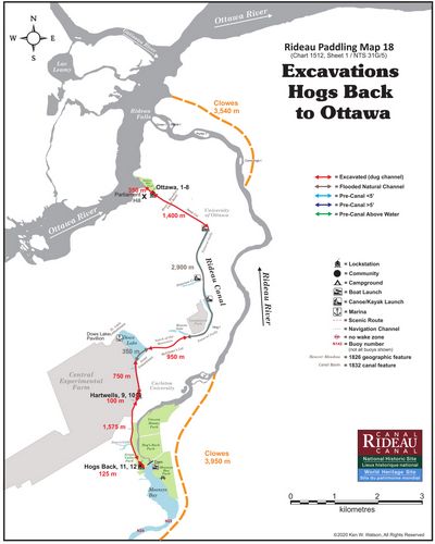
The Excavation MapsMy first challenge for this project was to find a map base
that could show excavation areas in sufficient detail for the
entire 202 km length of the Rideau Canal. The solution for
that was to re-purpose my 18 paddling guide maps, which
are scale accurate, highly detailed and in editable digital
format. This resulted in a set of 18 excavation
documentation maps covering the entire length of the
Rideau. The original is in colour, details are easy to see in a
PDF or at full printed size. Of interest in the above map of
the Ottawa Locks to the Hogs Back Locks is that By used
both excavation and slackwater to make a navigation way.
Only 62% of the Ottawa section of the canal is excavated,
the other 38% consists of flood
|
So, what are the numbers? The general number in use today is that 10% of the Rideau Canal is what we would consider to be man-made with the remaining 90% simply flooded lakes and rivers. Ten percent is actually pretty close and a good public number. If I add up the amount of visible excavation work (7.6%) and add in the amount of apparent excavation work in the form of gully clearing (2.4%) we end up at 10%. But that’s not the actual amount of man-made excavations. Actual excavations, which would be the lock pits plus visible and hidden (drowned) excavations that By had done totals 16.5 km (8.2%). However, that number doesn't include channel clearing (up to 33.9 km – 16.9%) or the above noted gully clearing. You can see where this starts to get complicated. Bottom line is the actual number in terms of excavation that By had to have done to create a navigable waterway is a number somewhere between 10% and 27% - the unknown is the channel clearing number, most of that is underwater in the southern Rideau and impossible to accurately measure.
How does this compare to Clowes’ canal proposal? In terms of the excavation of bypass channels, Clowes’ design adds up to 31.3 km with By’s design requiring less than half that number, at 15.0 km. Most of Clowes’ excavations would have been in solid bedrock. By avoided that where he could, most of his excavations were in gravels (with the notable exception of the Newboro cut). Clowes was also going to excavate a 19 km long channel along the Cataraqui River, while By was simply doing channel clearing, only excavating edges and high spots since he planned to flood the whole area to create the required navigation depth.
Documenting the challenge By faced in creating a 5 foot deep navigation way between Ottawa and Kingston shows that 24.8 km (12.3%) of the route of today’s Rideau Canal was above water in the pre-dam (pre-1784) era, with 130.4 km with water (rivers) that was less than 5 feet deep and 46.8 km (23.2%) with water over 5 feet deep (mostly the pre-canal lakes).
I do hope to complete a book on this topic at some point. As I note in an unfinished draft of the book (presently at 130 pages) "In addition to documenting the what and where of the work, this report also looks at who did it, how it was done and why decisions were made to result in the canal we see and enjoy today." While I have most of the what and wheres, the who, how and whys is a complex story requiring a fair bit of explanation. At some point, when I get time, I'll see about at least providing the raw data (spreadsheets and maps). But for the moment, the above is my brief synopsis of the results.
-Ken W. Watson
|