Rideau Heritage Viewscapes
by
Ken Watson, 2007
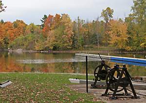 |
| Where's the Lockmaster's House?Can you spot the Locksmaster's House in this photo taken in October 2007 at the Upper Brewers Lockstation? Pay this lockstation a visit in 2008 and you'll clearly see it. |
I’m very pleased to see that Parks Canada has finally started to address a pet peeve of mine, heritage viewscapes. When I was writing “A History of the Rideau Lockstations” back in the late 1990s, I realized that I didn’t remember ever seeing the defensible lockmaster’s house at Upper Brewers lockstation, even though I had been to the lockstation several times. On my next trip I found it, hidden away by vegetation; you couldn’t see the lockmaster’s house from the lockstation and you couldn’t see the lockstation from the house. Parks Canada had allowed this building to become obscured by vegetation, completely removing it from its historical context. The same was true for several other defensible lockmaster’s houses such as those at Davis Lock and at Jones Falls.
 |
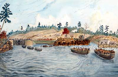
| House with a ViewThe lockmaster's house on top of the knoll at Upper Brewers with a commanding view of the approaches to the lock. Cropped section from "No. 21 / Brewer's (Upper Mills) Locks" by John Burrows, c.1840s. Libraries and Archives Canada, 1979-12-21. |
When these lockmaster’s houses were built, they were placed on the height of land at the lockstation, which had been cleared of trees, providing an unobstructed view of both approaches to the lock. This was done for two reasons. One was for military defence – these buildings were built of stone, with gun slits, tin roofs and other defensive features. During the next rebellion or American invasion, one didn’t want the enemy to be able to sneak up on these fortifications. The other was the fact that these were the living and working quarters for the Lockmaster, who required a clear view of both approaches to the lock to see traffic coming.
Unrestricted vegetation growth over the years has removed these building from their historical context. The heritage aspect of these buildings is not only the structures themselves, but their position on the landscape. We are fortunate on the Rideau, that, given proper heritage presentation, we can clearly understand today the role of these buildings. We don’t need 3D models or artist’s visualizations. Once the heritage viewscapes are restored, visitors to the site can see and understand for themselves the role of these buildings. It’s not only important for the Rideau, but also important from a Canadian history perspective; these buildings tell a tale of our early years, of tangible worries about rebellion, war and invasion. Parks Canada has now started to put some of these buildings back into the proper heritage landscape.
Kudos go to Mary Ann Stienberg, Visitor Services Officer of the Rideau Canal Office of Parks Canada, for getting this project going. When I first approached Parks with this issue a few years ago, I got some sympathetic noises, but no action. I approached the issue again, a couple of years ago, as a potential Rideau Legacy project. Mary Ann fully recognized the heritage presentation rationale behind my request, but one of the difficulties at that time was that it had to be a Parks project since it was on Parks Canada land with all the various regulations and restrictions that entails..
In the fall of 2007, Mary Ann was put in charge of several Katimavik students who were to be used for outdoor work, and with this group of eager labour, went to Superintendent Gavin Liddy for permission to move ahead with the heritage viewscapes project. Kudos to Gavin for recognizing the importance of the request and for giving Mary Ann the green light. Kudos too, to the local lockmasters, and to acting southern sector supervisor Anne-Marie Johnson, for fully assisting with the project, including assessing the potential viewscapes and determining exactly what should be done.
 |
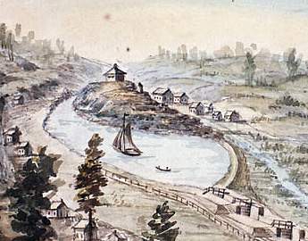
| Davis Lock in 1840The original wooden frame lockmaster's house at Davis Lock (centre of painting, behind the one tree that was left on the knoll) before the defensible locksmaster's house was built. Lock, Dam &c at Davis' Mill; Barges passing from the Lock to the Steamboat "Bytown", by Thomas Burrowes, 1840. Archives of Ontario, C 1-0-0-0-50. |
So, in October 2007, the environmental assessments of the sites were done, chain saws revved up, and the clearing began. The Parks Canada staff and the Katimavik students have done a great job (see photos at bottom of page). Visitors in 2008 will see a big difference at these sites.
In addition to the newly opened viewscapes, Parks Canada is putting policies and guidelines in place at these lockstations to maintain these viewscapes so that we don’t have to repeat this exercise in 25 years.
Heritage Viewscapes for 2008
This project has already started at several of the southern Rideau lockstations, specifically Upper Brewers, Davis, Jones Falls and Newboro. Note that Parks Canada is not taking these places back to their original landscape (which was generally devoid of trees) – but rather opening up selected viewscapes so that visitors can see and understand the role of the building’s position on the landscape. As a bonus, these new viewscapes are going to vastly improve the visitor experience to these lockstations by providing many great photo opportunities to and from these buildings.
At Upper Brewers, viewscapes on both sides of the lockmaster’s house are being opened up so that the house will be seen from both the lockstation (southern approach) and from the northern approach to the lockstation. When standing at the house, one will be able to see both the lock and the northern approach to the lock.
At Davis the southern viewscape has been opened up, providing visitors to the lockmaster’s house a clear view of Sand Lake. The view is particularly nice as you approach the lock from Sand Lake, the white clapboard kitchen of the house presents itself beautifully on the top of the hill. The opening of the northern viewscape (the view to/from Opinicon Lake) is pending a decision on the use of the building.
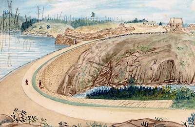 |
| Jones Falls Dam in 1841This painting clearly shows how the dam was locked into the bedrock. Section from "The Great Dam at Jones' Falls; from the West end," by Thomas Burrowes, 1841. Archives of Ontario, C 1-0-0-0-53. |
At Jones Falls, the stone face of the dam, which had become badly obscured by unrestricted tree growth, is being opened up. This will allow visitors to fully see and appreciate the engineering of the stone arch dam, to see (at least on one side) how the dam is locked into the bedrock of the canyon walls.
The lockmaster’s house (Sweeney house) at Jones Falls is having the southern view (to/from the Hotel Kenney) restored. The northern view (over 2 ridges) would require too much tree removal and isn’t being contemplated at the moment.
At Newboro, a clear view to/from the blockhouse is being assessed.
There are more sites that should be assessed and cleared, but this is a very good start.
Oh, and more kudos to Mary Ann Stienberg who is planning to add interpretive signage to these sites (yeah!! - I'm a big fan of interpretive signage).
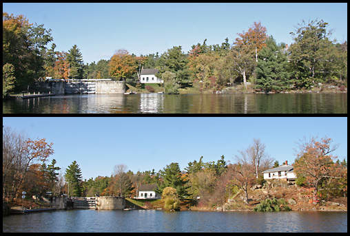 |
Before and After at Davis Lock
(before = October 16, 2007 | after = November 3, 2007) |
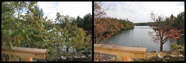 |
Before and After View looking to Sand Lake from the Lockmaster's House at Davis Lock
(before = October 16, 2007 | after = November 3, 2007) |
|