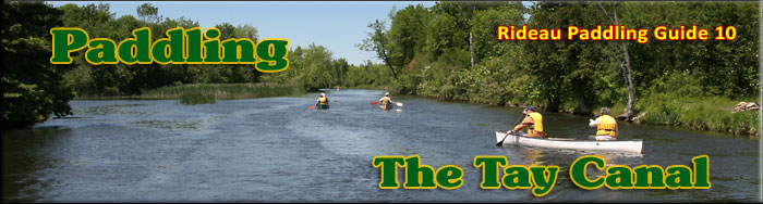
Paddling the Tay Canal
This is an easy paddling river with lots of marshland. The map included in this guide can be enlarged (while viewing the PDF) to any level of detail you desire as an aid for travel planning.
You can view or download the PDF file:
| (Clicking this link will open the PDF. You can also just right mouse click the above link and use "Save Target As" to send the PDF directly to your computer.) |


Water Access
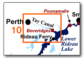
Water access is available at Beveridges Lock 33 (dock access upstream and ramp access downstream) or at Last Duel Park in Perth (dock and ramp: 44° 53.970'N - 76° 14.390'W).
Facilities
Lodging: If you're paddling and camping, the lockstations are a good choice for camp spots (a camping fee applies). Parks Canada also offers oTENTiks (a cross between a tent and a cabin) at Upper Beveridges Lockstation. There are also B&Bs and several hotels (Perth and Smiths Falls). For information about local accommodations see: www.beautifulperth.com and www.rideau-info.com
Supplies: A local source for supplies is the town of Smiths Falls or the town of Perth, both of which have full facilities (grocery stores, pharmacies, hardware stores).
Big Boats
You'll be sharing the Rideau with big power boats (cruisers). The Rideau is generally not a crowded waterway and often you'll find the large boats in "packs" - travelling from lock to lock - once they pass by you won't see any for awhile. Some of these boats can generate a large wave. The general rule for a paddler and large waves is to meet them head on, this can actually be fun in a kayak (not as much fun in a canoe).
The main navigation channel is shown on the map as a blue dashed line - this is where the big boats will be travelling. So, if you wish to avoid these, pick a route away from the navigation channel. Many paddlers prefer paddling near shore, it's more interesting (i.e. wildlife, cottages) and it keeps you farther away from the waves produced by big boats.
There are several "no wake" zones on the Rideau - these have been marked on the maps. Boaters within these areas are supposed to be travelling at a slow enough speed (less than 10 kph) that their boat doesn't generate any potentially damaging or dangerous waves.
Wind
A question often asked is which way does the wind blow? The prevailing wind, powered by the jet stream, is from the southwest. That's about the only rule of thumb. If a front is moving in then the wind can come from any direction. I've been on several paddles where I've been paddling into the wind on the way out in the morning and into the wind on the way back in the afternoon because the wind swung around 180 degrees (for some reason it never seems to work the other way around - at your back both ways). So, if you're going to travel the entire Rideau, going from Kingston to Ottawa improves the odds of having the wind at your back - but be prepared for anything.
Etiquette
Your trip planning should include a "leave no trace" approach - carry out what you carry in. Many areas are un-serviced (no garbage cans) - so plan to be self-contained. The lockstations provide waste disposal facilities.
Preparation & Safety
Please read the trip planning information on www.rideau-info.com/canal/paddling/. While these lakes are easy paddling, normal paddling preparations should be made (all required safety gear, maps, food, water, first-aid kit, etc.). Zebra mussels are present in many areas along the Rideau, so a pair of water shoes (to avoid cut feet) is recommended.
Please take all normal safety precautions, including checking the weather forecast before you head out and making sure that someone on shore knows your planned travel route and itinerary.
Navigation
While the Rideau is generally easy to navigate, taking along a set of maps is a must (in addition to any GPS you might have). Although the map in this guide is an accurate 1:50,000 representation of the waterway (when printed to 8.5" x 11"), you may also wish to also have the 1:20,000 hydrographic chart for this section (Chart 1513). For power boat navigation, the charts are an absolute must (the map in this guide should not be used for power boat navigation). The charts are also very handy for the paddler, since they show the Rideau in great detail, including depths (which can be helpful when looking for wildlife habitat or just interesting places to paddle).
The charts also show all the navigation buoys. These are all numbered (red buoys have even numbers, green buoys have odd numbers) and so can be used as an aid in locating yourself on the map when you're on open water. A subset of those buoy numbers have been included on the paddling guide maps.
For those wishing to go off the beaten path or want to know more of the topography and geographic features of the surrounding countryside, the 1:50,000 NTS map for this section is 31C/16.
Distances:
- Beveridges Lock 33 to the Perth Basin along the navigation channel = 9.7 km (6.1 mi)
- Beveridges to Perth Basin via the scenic route = 11.0 km (6.8 mi)
The Tay Canal
The Tay Canal follows a dredged cut from the Beveridges Locks to the original channel of the Tay River. Several sections from that point to Perth have been dredged. There is a slow moving current and extensive marshlands surround the canal in the southern half of the route. Aquatic vegetation growth is present in most sheltered areas that have a water depth of less than 10 ft (3 m). Wildlife is abundant, particularly herons, ospreys, ducks, turtles, frogs, muskrats and beavers.
The paddler will have no trouble getting into the Perth Basin. The Craig Street bridge, just north of Last Duel Park, has a fixed height of 7 ft (2.1 m). A little farther up, the Beckwith Street bridge (a swing bridge) has a unswung clearance of 5.2 ft (1.6 m) and past that the Drummond Street fixed bridge has a clearance of 9.5 ft (2.9 m).
The Locks
Most Rideau lockstations offer facilities such as washrooms, water, recycling cans, waste cans and picnic tables. Most also allow camping for paddlers travelling the Rideau for a modest camping fee. Paddlers can portage the locks for free, but you owe it to yourself to lock through at least one lock in order to get the full experience of paddling the Rideau Canal. See www.rideau-info.com/canal/fees.html for the current fee schedule.
Points of Interest (listed south to north)
Beveridges Locks: There are two separate locks at this station (lift of Lower Beveridges = 12 ft /3.6 m - Upper Beveridges = 10.9 ft /3.3 m). Although these look just like original Rideau Canal locks, they were in fact built over fifty years after the Rideau Canal was built. Constructed in the late 1880s, they were built using the original design specifications of the Rideau locks.
Tay Canal: The Tay Canal has a very interesting history. Today's canal, starting at Beveridge Bay, is actually the 2nd Tay Canal, constructed in the late 1880s. The 1st Tay Canal was opened in 1834 and went from Perth to Port Elmsley. It consisted of 5 locks, 6 dams (with timber slides), two swing bridges and several embankments. The locks were 90 feet long by 20 feet wide (27 x 6.1 m) and a depth in the channel of 3.5 feet (1.1 m). This would accommodate any type of Durham boat and even some small steamers. The 1st Tay Canal was never a commercial success and it fell into disuse and was shut down by 1865.
The 2nd Tay Canal came about from a lobby by Perth business people, championed by local Minister of Parliament, John Haggart. The locks, started in 1885, were built to Rideau Canal standards and were completed in 1887. At this time dredging technology was available, so the required depth of navigation was created by a combination of building a dam and creating/deepening the channel by dredging. Final excavation of the Perth Basin was completed in 1891. For a time this 2nd Tay Canal was knows as "Haggart's Ditch."
The Tay provides many wildlife viewing opportunities, particularly of marsh-loving birds. Take the scenic route along the original channel of the Tay River to view extensive marshland environments. You'll likely see ospreys, herons and the reclusive Pied-billed Grebe (a small diving bird).
Beveridge Bridge: This is a fixed high level (6.7 m / 22 ft) bridge which dates to about 1961. It replaced a swing bridge, built in 1898, that used to be located just south of the present day bridge (you can still see the abutments). That swing bridge was removed in 1961 and installed at Narrows Lockstation in 1964.
First Tay, Lock 5: You can still see the remains of old lock 5 of the First Tay Canal, completed in 1834, on your paddle to Perth. It is located near the confluence of Jebbs Creek and the Tay River, adjacent to the viewing platform in the Perth Wildlife Reserve. The main channel is a dredged cut to the north of the old lock - you can paddle a little ways up the original canal channel. A dock and picnic area were put in place here in 2014.
Perth Wildlife Reserve: This 257 ha wildlife reserve is highlighted by a 2.5 km walking trail. Access from the water is easy via the dock at the location of old lock 5 of the first Tay Canal (see above). You’ll also find a viewing platform at this location. The reserve is run by the Rideau Valley Conservation Authority. More info and a trail guide is available at: www.rvca.ca
Last Duel in Upper Canada: A small meadow on the north side of the north end of an original Tay River meander, just south of Last Duel Park (near where a set of power lines cross the Tay Canal), is the presumed site of the Last Duel in Upper Canada. It happened on June 13, 1833, between Robert Lyon and John Wilson. The loser of the duel is buried in the Old Burying Ground (1821 - 1972) located beside Last Duel Park. You can read all about it in my Tales of the Rideau.
Last Duel Park: This is municipal day park operated by the Town of Perth – both day use and camping are permitted. Boater access is from the public docks and boat ramp at the north end of the park.
Craig St. Bridge: This is fixed low level (2.1 m / 7 ft) bridge built in 1954. This bridge effectively cuts off most boat traffic into Perth. It replaced a swing bridge that was originally erected c.1889 with the building of the 2nd Tay Canal. The restriction of boats into downtown Perth had actually started several years before, when, in 1941, the Beckwith Street and Drummond Street swing bridges were both fixed in place.
Beckwith St. Bridge: This is a swing bridge with a closed clearance of 1.6 m / 5.2 ft. The bridge was originally installed c.1890, with the building of the second Tay Canal. It was made into a fixed bridge in 1941 (sealed in the closed position). A local lobby eventually returned the bridge to being a swing bridge (likely in the early 1980s). In 2010 it was extensively rehabilitated.
Drummond St. Bridge: This is a fixed low level (2.9 m / 9.5 ft) bridge. The original bridge in this location was a swing bridge, built at the same time (c.1890) and in a similar style to the Beckwith St. Bridge. It was made into a fixed bridge in 1941 (sealed in the closed position). The bridge was replaced with a new concrete superstructure on the original (rehabilitated) footings sometime after 1976 (likely in the 1980s).
Perth Basin: A harbour in downtown Perth, the basin, as we see it today, was created with the building of the second Tay Canal. After the Craig Street fixed bridge was installed in 1954, the basin silted up (the fixed low level bridge prevented dredge access). It was noted in 1978 that Perth was the only local community with a swamp in the middle of it. Perth initiated a revitalization project in 1980, and it appears the basin was rehabilitated some time after that. Today it presents a lovely appearance to visitors arriving by land or by water. In 2009, Friends of the Tay Watershed installed new low-level docks to make the basin paddler friendly.
Gore St. Bridge: This is a fixed low level (2.7 m / 9.0 ft) bridge. The original bridge near this location was a large elm tree, felled to connect Cockburn Island with the Brockville Road. It was replaced by a timber bridge and then a stone arched bridge. The bridge location became known as Locke's Bridge. In 1890, with the building of the second Tay Canal, the fixed stone bridge was replaced by a swing bridge. The present concrete bridge was built in 1957.
Perth: Perth is a fascinating place to explore. It features many interesting shops and restaurants and makes for a great day tour or weekend outing. It was founded in 1816 and today the many historic stone buildings make Perth one of the prettiest towns in the region. A heritage walking tour of Perth can be found on-line.
Scenic Route
The scenic route simply involves following the original channel of the Tay River. Follow the main navigation channel to marker buoy N11 and then head south (left) into the first meander. This is an area generally undisturbed by boat traffic - go slow and keep your eyes and ears open for wildlife. Continue through the second meander and then back to the main channel.
The Upper Tay
If you paddle past the Perth basin, you’ll be entering the upper Tay River which flows from Christie Lake. This can be paddled with several short portages. Information about the Upper Tay along with several suggestions for paddling routes in this area can be found on the Friends of the Tay Watershed website www.taywatershed.ca
Geology
As you paddle the Rideau Canal, the route you follow is defined by its geology. Geological highlights have been included in the Points of Interest listings and a general geological history of the route can be found on the Geology of the Rideau Page.
Wildlife Viewing
A section about wildlife viewing, what you might expect to see on your Rideau journey, has been included in text form in the PDF. A version of this information, that includes photos of some typical Rideau wildlife, can be found on the Fauna of the Rideau Page (in the ecology section of this website).
Errors
If you find any errors or omissions in this guide, please let me know (rideauken@gmail.com) and I'll get them fixed.
Terms of use
This guide may be freely used for personal purposes. Have fun on your Rideau paddling adventure.
Commercial use is not allowed in whole or in part without express written permission.
©2010-2015 Ken W. Watson, All Rights Reserved.
You can view or download the PDF file:
| (Clicking this link will open the PDF. You can also just right mouse click the above link and use "Save Target As" to send the PDF directly to your computer.) |
|