|
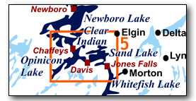
Includes Sand and Opinicon lakes
Sand Lake and Opinicon Lake, bounded by the Jones Falls Locks at the south end, Chaffeys Lock at the north end, and including Davis Lock in the middle, makes for great day paddling experiences. Both lakes offer many islands and winding shoreline and so can be paddled even when the wind is up. The map included in the PDF version of this guide can be enlarged to any level of detail you desire.
No specific route descriptions have been given for paddling the lakes - you should explore these on your own. The detailed map in this guide will allow for travel planning. However, for those just paddling through the lakes (going lock to lock), a scenic route has been suggested. In addition, a couple of "off the beaten path" suggestions have also been made.
You can view or download the PDF file:
| (Clicking this link will open the PDF. You can also just right mouse click the above link and use "Save Target As" to send the PDF directly to your computer.) |
You can also view a short photo tour video of this area:

Water Access
Sand Lake: There are several points of access to the lake. The two municipal boat launches, one at the end of Battams Road (44° 35.110'N - 76° 14.910'W - gravel, no dock) and one at the end of Glovers Road (44° 34.040'N - 76° 14.700'W - paved, small dock), have very limited parking but do offer direct into water access. The other options are the two lockstations, Davis and Jones Falls, both require a short portage from the parking area to a launch point. With Jones Falls, if you just wish to do Sand Lake, then you can go into the Jones Falls Dam parking lot (44° 32.925'N - 76° 14.160'W) and then launch from the top of the dam (a picnic area with wharfs). You can also launch at Sand Lake Marine (44° 33.490'N - 76° 14.930'W) for a fee.
Opinicon Lake: There are three access points. At Chaffeys Lock, you can launch from the ramp (44° 34.695'N - 76° 19.145'W) adjacent to the docking for the Opinicon Hotel. You can also park at Davis Lock (44° 33.825'N - 76° 17.440'W) and launch from there. You can also launch from Franklin's Marina (44° 34.890'N - 76° 18.600'W).
Facilities
Lodging: If you're paddling and camping, the lockstations are a good choice for camp spots (a camping fee applies). There are also several campgrounds, a host of B&Bs and several hotels such as the Hotel Kenney at Jones Falls, the Opinicon Resort Hotel at Chaffeys Lock and the Poplars and Stirling Lodge in Newboro. For information about local accommodations see:, www.rideaulakes.ca and www.rideau-info.com (this website).
Supplies: A local source for supplies is the village of Elgin (off Hwy. 15 opposite Davis Lock Road), which has a grocery store, pharmacy and hardware store. Groceries can also be obtained in Westport.
Big Boats
You'll be sharing the Rideau with big power boats (cruisers). The Rideau is generally not a crowded waterway and often you'll find the large boats in "packs" - travelling from lock to lock - once they pass by you won't see any for awhile. Some of these boats can generate a large wave. The general rule for a paddler and large waves is to meet them head on, this can actually be fun in a kayak (not as much fun in a canoe).
The main navigation channel is shown on the map as a blue dashed line - this is where the big boats will be travelling. So, if you wish to avoid these, pick a route away from the navigation channel. Many paddlers prefer paddling near shore, it's more interesting (i.e. wildlife, cottages) and it keeps you farther away from the waves produced by big boats.
There are several "no wake" zones on the Rideau - these have been marked on the maps. Boaters within these areas are supposed to be travelling at a slow enough speed (less than 10 kph) that their boat doesn't generate any potentially damaging or dangerous waves.
Wind
A question often asked is which way does the wind blow? The prevailing wind, powered by the jet stream, is from the southwest. That's about the only rule of thumb. If a front is moving in then the wind can come from any direction. I've been on several paddles where I've been paddling into the wind on the way out in the morning and into the wind on the way back in the afternoon because the wind swung around 180 degrees (for some reason it never seems to work the other way around - at your back both ways). So, if you're going to travel the entire Rideau, going from Kingston to Ottawa improves the odds of having the wind at your back - but be prepared for anything.
Etiquette
Your trip planning should include a "leave no trace" approach - carry out what you carry in. Many areas are un-serviced (no garbage cans) - so plan to be self-contained. The lockstations provide waste disposal facilities.
Preparation & Safety
Please read the trip planning information on www.rideau-info.com/canal/paddling/. While these lakes are easy paddling, normal paddling preparations should be made (all required safety gear, maps, food, water, first-aid kit, etc.). Zebra mussels are present in many areas along the Rideau, so a pair of water shoes (to avoid cut feet) is recommended.
Please take all normal safety precautions, including checking the weather forecast before you head out and making sure that someone on shore knows your planned travel route and itinerary.
Navigation
While the Rideau is generally easy to navigate, taking along a set of maps is a must (in addition to any GPS you might have). Although the map in this guide is an accurate 1:50,000 representation of the waterway (when printed to 8.5" x 11"), you may also wish to also have the 1:20,000 hydrographic chart for this section (Chart 1513). For power boat navigation, the charts are an absolute must (the map in this guide should not be used for power boat navigation). The charts are also very handy for the paddler, since they show the Rideau in great detail, including depths (which can be helpful when looking for wildlife habitat or just interesting places to paddle).
The charts also show all the navigation buoys. These are all numbered (red buoys have even numbers, green buoys have odd numbers) and so can be used as an aid in locating yourself on the map when you're on open water. A subset of those buoy numbers have been included on the paddling guide maps.
For those wishing to go off the beaten path or want to know more of the topography and geographic features of the surrounding countryside, the 1:50,000 NTS map for this section is 31C/9.
Distances:
Circumference distances are approximate, following the main shorelines. The navigation channel and the scenic route are shown on the map.
- Sand Lake Circumference (main shorelines): 35 km (22 mi)
- Jones Falls to Davis Lock along navigation channel: 7.0 km (4.3 mi)
- Jones Falls to Davis Lock taking the scenic route: 6.5 km (4.0 mi)
- Opinicon Lake Circumference (main shorelines): 45 km (28.0 mi)
- Davis Lock to Chaffeys Lock along navigation channel: 3.3 km (2.0 mi)
- Davis Lock to Chaffeys Lock taking the scenic route: 6.1 km (3.8 mi)
The Lakes
Sand Lake
This is the southernmost of the original Rideau lakes. In the pre-canal era, the lake was 8 feet (2.4 m) lower than it is today and drained, through the Jones Falls Rapids, into the White Fish River to Lower Beverley Lake. The completion of the Great Dam at Jones Falls in the fall of 1831 drowned the rapids and raised the level of the lake to what it is today.
The lake has a maximum depth of 50 ft (15 m) and averages 20 to 25 ft (6 to 7 m). It's a mesotrophic lake (moderately enriched with nutrients). The water temperature reaches 20°C (68°F) by early June and stays that way until mid-September (peak temp is generally 25°C / 77°F). Zebra mussels are present. Aquatic vegetation growth is present in most sheltered areas with a depth of less than 10 ft (3 m).
The land bordering the lake is mostly privately owned (the exceptions being federal land in the vicinity of the lockstations). About two-thirds of the lake has moderate density cottage and summer home development, the rest remains in its natural state. Wildlife is abundant, particularly loons, herons, ospreys, turtles, frogs, muskrats and beavers. The main game fish is large mouth bass (small mouth bass, northern pike and crappie are also present).
Opinicon Lake
In the pre-canal era, this lake was about 10 ft (3 m) lower than it is today. The outflow was to Sand Lake through Davis' Rapids and the inflow was mostly from Indian Lake, through Chaffey's Rapids. In the fall of 1831, the completion of the lock and dam at Davis Lock raised the water in the lake to the level it is today. You'll sometimes see the lake incorrectly called "Lake Opinicon." That is the name for a former community at the southwest end of the lake (see map).
The lake has a maximum depth of 27 ft (8 m) and averages about 20 ft (6 m). It's a mesotrophic lake, slightly more enriched with nutrients than Sand Lake. Zebra mussels are present. Aquatic vegetation growth is present in most sheltered areas with a depth of less than 10 ft (3 m).
The land bordering the lake is mostly privately owned (the exceptions being federal land in the vicinity of the lockstations and several large tracts of land owned by Queen's University). About two-thirds of the lake has moderate density cottage and summer home development, the rest remains in its natural state. Wildlife is abundant, particularly loons, herons, ospreys, turtles, frogs, muskrats and beavers. The main game fish is large mouth bass (small mouth bass, northern pike and crappie are also present).
The Locks
Most Rideau lockstations offer facilities such as washrooms, water, recycling cans, waste cans and picnic tables. Most also allow camping for paddlers travelling the Rideau for a modest camping fee. Paddlers can portage the locks for free, but you owe it to yourself to lock through at least one lock in order to get the full experience of paddling the Rideau Canal. See www.rideau-info.com/canal/fees.html for the current fee schedule.
Points of Interest (listed south to north)
Jones Falls Lockstation: This is one of the prettiest lockstations on the entire Rideau. It consists of an upper lock, a turning basin and a flight of three locks (total lift of 17.3 m / 56.9 ft). At the foot of the locks is the historic Hotel Kenney (also a snack bar - offering tasty treats). The link from the hotel to the locks is over a wooden bridge, originally built in 1883. This was part of a roadway that led to a swing bridge over the middle lock. Today only the abutments for that swing bridge remain.
You'll find a small visitor centre (with washrooms) near the top of the combined locks. The road leads from there to the upper lock. As you walk up that road and look down, you'll see an old road angling down to Jones Falls Bay. This is part of the original haul road for the stones (sandstone) used in the building of the locks, which were brought by wagon from a quarry near Elgin, 10 km (6 mi) away.
Just below and to the west of the upper lock is a blacksmith's shop built in the 1840s.
Above the upper lock is a defensible lockmaster's house (a stone building with gun slits, built in the 1840s). It is known as Sweeney House, after the first lockmaster, Peter Sweeney (a diary that he kept while living there with his family is available in book form as The Sweeney Diary).
Between Sweeney House and the dam you'll find the waste water weir, blasted (using black powder) through a bedrock ridge (you can still see the remains of some of the hand-drilled blast holes). The present weir was rebuilt in 2011. The water flows through this weir to form Redpath Falls, named after the contractor who built the locks and dam, John Redpath.
A walking trail exist around the west side of the basin (from the Lockstation House to the Blacksmith's Shop).
At the time of the building of the Rideau Canal, the locks at Jones Falls featured the greatest lift (15 ft / 4.6 m each) and consequently the tallest lock gates of any lockstation. There was some worry about the size of the gates, whether they could stand up to the water pressure. They served well, being replaced with new gates on a regular basis (every 20 years or so). However, in 1869, the gates between Lock 40 and 41 apparently failed, allowing one barge to crash into another. Two men were killed. As it turns out, the failure of the gates was a result of the accident, not the cause, and that full story is related in Tales of the Rideau. No gate has failed since that time.
Jones Falls Dam: The most impressive feature at Jones Falls is the Great Stone Arch Dam - the largest dam built during the construction of the Rideau Canal. It is 107 m (350 ft) wide at the top (following the arch) and 30.5 m (100 ft) wide at ground level. The height of the stonework from its base (buried 1.8 m (6 ft) below surface) is 17.4 m (57 ft) and an earthen berm adds about another 1.2 m (4 ft), making the dam about 18.6 m (61 ft) high. It is known as the "whispering dam" since a person standing at one end, talking in regular conversational tone, can be heard by someone at the other end of the dam - the face of the dam providing a reflecting surface for sound.
The dam is located in the bed of the original Jones Falls Rapids. These rapids dropped 18.9 m (62 ft) over a distance of a 1.6 km (1 mile). The dam is actually located some 440 m (1,450 ft) up from the foot of the rapids (today's bridge below the locks marks the foot of the original rapids). It was placed in a constriction in a rocky gorge that allowed the dam to lock itself into the bedrock on either side. This is the purpose of the arch shape of the dam, it throws part of the immense weight of water that it is holding back into the bedrock on either side of the dam.
As you look down to the valley below the dam, you're looking at the original channel of the White Fish River, one of the very few "natural topography" spots remaining on the Rideau (since most of the original topography on the Rideau is now below water).
The power generating station, built in 1947, required tunnels to be excavated through the dam for the three penstocks. The penstocks leading down to the power station are built of wire wrapped wood. This privately owned power generating station is still in use today. You can tell which penstocks are being used at any given time by the sprays of leaking water.
Jones Falls Bridge: This is a fixed high level (7.0 m / 22.7 ft) bridge which carries the Jones Falls Road (Cty. Rd. 11) across the Rideau Canal. It was built in the late 1970s. Prior to this bridge being built, road access was over the wooden swing bridge at Lock 41 (which ceased being used when the fixed bridge was completed).
The Quarters/Jones Falls Portage: As you paddle north from Jones Falls, you're paddling over the now flooded, Jones Falls Rapids. The head of the rapids was at the first narrow constriction at the foot of Eel Bay. The south shore of the pond just downstream from this first constriction is known as The Quarters. The Jones Falls Rapids were not navigable by canoe and so there was a 1,370 m (1,500 yd) portage going around the rapids. The Quarters is at the head of this portage, so named since it was the location of the Officer's Quarters (Royal Engineers) during the construction of the locks and dam at Jones Falls (1827-1831). This location was chosen since any people or goods arriving by water from Sand Lake had to disembark at this location. It also provided the only access to the site prior to a road being built from the quarry (near Elgin) to the lock site in 1827.
Sand Lake: This is a typical Rideau lake, its many bays and islands offering the paddler several choices of route. Several of the back bays feature marsh land and you'll find an abundance of birds and animals that prefer this type of habitat. The lake hosts a healthy population of loons (normally about 22 adult loons), and if you look up to the tree tops, you'll see several osprey nests. A typical cottaging lake, it offers a wide variety of architectural styles of cottages and boathouses. In 1827, surveyor John Burrows wrote, when entering the lake (from Davis' Rapids) at sunrise, "The view of Davies Lake [Sand Lake] is very pleasing. The many islands, as if floating on a transparent mirror which mellowed and reflected by the tint of the morning, strikes the contemplative mind with a sensation of pleasure not easily forgotten."
Birch Island: this island was a peninsula prior to the flooding of Sand Lake by the dam at Jones Falls. Farming started on the island in the mid-1800s. In the 1890s, cottage development started on the east end of the island. The west side of the island was purchased in the late 1890s by a local farmer, Lotan Burtch. He used it to graze sheep and cattle. His son, Howard, sold his island holding in 1968 to Birch Island Estates, allowing for extensive cottage development of the island. An interesting feature on the south side of the island is an old lime kiln. This kiln was used by the Jackson brothers to make quicklime in the early 1900s. The bedrock of Birch Island is Precambrian crystalline limestone.
Birch Island Culverts: normally culverts do not constitute a Point of Interest, but the ones at the west end of Birch Island do - you'll see these if you take the scenic route around Birch Island. The culverts are what's left of a road crossing from the mainland to the island. The story goes that sometime in the 1960s, a landowner on the island made a deal with the farmer who owned the mainland property to provide a road right of way. The landowner constructed the road, a causeway and a bridge. In the late 1960s, the island was developed with cottage lots and many people started to use the road. The farmer objected, his deal had been to allow one person road access, not to everyone wanting access to the island. The dispute ended up in court, the farmer won and the bridge was removed. Today you can see the bridge abutments, but no bridge, as you paddle around the west end of the island. The culverts under the causeway remain in place.
Freed Island: This island features a beautiful old summer home. Originally known as Cordwood Island, it was used to stockpile cut wood for use by the steamships that plied the Rideau Canal in the 1800s. In about 1889 the island was sold to David Freed of Philadelphia who developed it as a summer estate. It was sold in 1983 to the Marshall family. Chicken Island, just to the west, was used to raise chickens for the Freed family.
Davis Lock: Known as a "solitude lock" since there is no nearby community, it has a single lock (lift of 2.6m / 8.7 ft). It also has one of the best preserved examples of a defensible lockmaster's house. The grassy knoll between the lock and the weir is actually the canal dam which has raised the level of Opinicon Lake by about 10 ft (3 m).
Prior to the canal, this was a set of rapids (no portage) which drained Opinicon Lake into Sand Lake. A miller, Walter Davis Jr., built a dam and sawmill here in about 1820. The sawmill was located at the lock-side foot of the knoll on which the lockmaster's house sits today. Colonel By bought out Davis's mill property to allow the lock and dam to be built (in fact, Davis' mill dam was used as a coffer dam to aid the construction of the canal dam).
The weir opening, which today drains Opinicon Lake into Sand Lake, was blasted (using black powder) though the bedrock ridge.
Opinicon Lake: Very much the same as Sand Lake, it has mostly low density cottage and summer home development. It does offer a couple of "off the beaten path" paddling possibilities (access to Hart Lake and to Lower Rock Lake; see below). Wildlife in abundant (see Sand Lake description), you may even spot swans that have been known to reside in the lake.
Queen's Biology Station: On the northwest shore of the lake you'll see a large white building. This is part of the Queen's University Biology Station. The idea for the station was conceived in 1936, but it was not until 1944 that the land on which the station is now located was purchased. The building that you can see by the water was built in 1946. Queen's owns several large tracts of land on Opinicon Lake and does extensive biological (flora and fauna) studies of the area. As you paddle the lake you may see biology students out and about investigating various things. They have an open house once a year and sometime offer public interpretive programs.
Deadlock Bay: The name “Deadlock Bay” is from a tale that this was to be part of the original route of the Rideau Canal, a route that would take the canal through Hart Lake. Evidence for this is in the form of a lock started but never completed, a "dead lock." It's a tall tale but you can still evidence of the dead lock today.
The Dead Lock is a constriction in the channel at the head of Deadlock Bay, the outlet today of Peterson Creek which flows from Hart Lake into Opinicon Lake. This small canyon with its vertical rock walls may have looked like the start of a lock to some. Prior to the rapids at Davis Lock being dammed, Opinicon Lake was much smaller, ten feet lower than it is today. There would have been rapids at the location of the small canyon. Today, with the water in the lake raised due to the dam at Davis Lock, there is still water in that location, making it look more "lockish". You can also see stones piled up on the upstream side of the canyon, a clear sign of human activity. These stones are the remains of the abutments of a bridge for a wagon road that went to phosphate mines located to the west of Peterson Creek (just south of Hunter Bay). Those mines operated, on and off, between 1870 and 1892 (see Hunter Bay below).
There is a second, less likely, but perhaps more interesting candidate for the dead lock, large stacked stones located just a bit downstream of the head of Peterson Creek, the outlet to Hart Lake. You'll see these stones on the west side of the creek, just a few metres upstream of the foot of the short portage that leads to Hart Lake. Those stones were part of a dam built to supply water to a sawmill, most likely built by Robert Drummond in about 1832. Just upstream for that site are piles of smaller stones, the remains of a Rideau Canal reservoir dam originally built in 1872 and rebuilt in 1889. It was torn down (or blown up) by local residents after the 1889 rebuild.
Indigenous Canoe Route from Kingston - Deadlock Bay is also the location of a indigenous canoe route from Kingston to the Rideau. Prior to mill dams, and later Rideau Canal dams, making the section north of Upper Brewers to south of Jones Falls navigable, the indigenous travel route from Kingston was up the Cataraqui River to its headwaters in Loughborough Lake. Then from Loughborough Lake to Hart Lake and from there down Peterson Creek into Opinicon Lake. At that time there was no Deadlock Bay, Opinicon Lake was 10 feet lower than it is today and the edge of the lake was near the foot of today's bay.
Hunter Bay - Milling and Mining: Opinicon Lake was an active area for both milling and mining in the late 1800s and early 1900s. A good example of both can be found in Hunter Bay. At the head of this bay is a constriction, the location of the old Hunter Mill, first established by James Hunter in the 1850s. It occupied the site of a former sawmill, Brewers Mill, that was likely built at about the same time as the Drummond mill mentioned in the Deadlock Bay section (ca.1832).
Above that constriction is the old mill pond, and on either side of that you can see evidence of mining activity. These were phosphate mines and/or exploration trenches. Phosphate is contained in the mineral apatite and was mined for its use as fertilizer. Exploration was done by digging trenches across the strike (direction) of the rock units that would potentially hold apatite (the mineral that contains phosphate). If they found some they would simply continue by digging deeper - the distinction between an exploration trench and mine is fuzzy. The first mining in this spot was done by Alexander Cowan in 1870. The mines are very small by today's standards, the largest one in this location was the Opinicon Rock Lake Phosphate Mine which was done as an angled cut, 75 feet (23 m) wide and extending down 225 feet (68 m) on a 45° incline. It operated under a couple of owners from 1888 to 1892 and extracted about 1,500 tons of phosphate which was then loaded onto barges and eventually shipped to England and Germany.
Sometime in the late 1800s or early 1900s the property was purchased from the Hunter estate by a fellow that went by the name "Admiral Horatio Nelson Sharp" who started the Opinicon Ranching Company. In about 1919, Sharp sold the property to the Wright family who continued farming the land for some time. In 1989 this 315 acre property was purchased from Opinicon Properties Ltd. by Queen's University. It was named the Cape-Sauriol Environmental Studies Area in 1990 in honour of Brigadier General John M. Cape, who made a generous donation towards the acquisition of the land, and Charles Sauriol, who played a crucial role in the fund raising efforts.
Lake Opinicon: This is the site of a former community established in the late 1870s. It became a village that serviced the very active milling and mining industry on the lake. As economic activity faded (phosphate (apatite) mining by the early 1890s, mica mining and sawmills by the early 1900s), so did the village. Today only a few houses mark the location of this once bustling community.
Barrel Point: The name comes from a tale of a lost treasure, a barrel of silver coins. The tale could well be true since during the construction of the Rideau Canal the workers were paid using silver coins (American half-dollar coins). These coins had to be transported from Bytown to the worksites, and in one tale, a canoe carrying a barrel of these coins overturned in Opinicon Lake, somewhere off of Barrel Point. Those lost coins have yet to been found (others have been). This story is recounted in detail in my book Tales of the Rideau.
Navigation Channel near Chaffeys: You'll notice that the navigation channel takes a somewhat circuitous route into Chaffeys Lock. That's because the channel, starting from a point opposite Rabbit Island, is following the course of the rapids (river) that originally flowed from Indian Lake into Opinicon Lake. The dam at Davis Lock drowned this original channel, but today's navigation buoys mark its location.
Chaffeys Lock: The lockstation has a single lock (lift of 3.3 m / 11.0 ft) and a swing bridge. The lock is located in the middle of what used to be the Chaffey's Rapids which drained Indian Lake into Opinicon Lake. A long (1,370m / 1,500 yd) portage used to lead around these rapids. In 1820, brothers Samuel and Benjamin Chaffey erected a sawmill here. In 1822 Samuel started building other mills and by 1826 had a sawmill, grist mill, carding mill and distillery in operation. He died in 1827 and sometime after that Colonel By tried to buy out the milling operation in order to build the lock and weir.
However, an ownership dispute between Samuel's widow Mary Ann and his brother Benjamin prevented settlement, and it wasn't until October 1829 that Mary Ann and Benjamin resolved their dispute allowing the mills and land to be purchased for £2,000 (equivalent to several million dollars today). The mills were removed in 1830 to make way for the lock construction.
The first bridge across the lock was a kingpost truss wooden swing bridge installed in 1884. It was repaired over the years and replaced in 1949 by a steel through plate girder swing bridge. That bridge was replaced by one of a similar design in 2015.
The defensible lockmaster's house, built in 1844 with the second storey added in 1894, has been converted into a museum, the Lockmaster's House Museum. It is operated by the Chaffeys Lock and Area Historical Society and houses interesting photos and exhibits. It is well worth a visit.
You'll also see the old Chaffey's Mill (built by John Chaffey in 1872) which used the flow of water from the canal weir to power its operation. It is privately owned and currently being restored and converted into a B&B.
Chaffeys Locks: This is the small community at this location. It was established in the early 1870s when John Chaffey (a nephew of the original miller, Samuel Chaffey) came here and built a mill (the old Chaffey's Mill that you can see today). It's known as Chaffeys Locks since two locks were originally proposed for this location, but in the end, only one was built. In "town" you will find the entrance to the Chaffey's Lock Cemetery and Memory Wall , located beside the Brown's Marina store. This cemetery was used for those who died during the construction of the canal at this location and also for local residents (to the late 1800s). You can also get to the cemetery (or return from the cemetery) by taking the Marion Dunn Heritage Trail, the entrance to which can be found near the Community Hall. The community is also home to the lovely old Opinicon Hotel which had its start as a tenant house, built in the early 1870s, to house the workers for John Chaffey's mill. It evolved into a tourist home, then a private fishing club and then, starting in 1921, became a tourist resort.
A walking tour brochure of Chaffeys Locks is available in the hamlet and on-line.
Iron Bridge/Cataraqui Trail: Just to the north of the locks you'll paddle under the old Iron Bridge (9.1 m / 29.5 ft above the water), built in 1912 by the Canadian Northern Railway as part of their Montreal to Ottawa to Toronto line. The tracks were lifted in the early 1990s and, in 2000, it became a crossing for the Cataraqui Trail, part of the Trans-Canada Trail system. The old Chaffey's railway station is located just a few hundred metres southwest of the bridge. Chaffeys Locks is at km 42 of the 102 km long trail which stretches from Smiths Falls (km 0) to the east to Strathcona (km 102) to the west.
Route Suggestions
Sand Lake
Scenic Route: follow the main navigation channel from Jones Falls to Eel Bay. Once in the bay, stay to the south shore and paddle past the south side of Birch Island. A small channel at the west end of Birch Island puts you back into the main part of Sand Lake. Continue hugging the south shore to Fahey Island. Pass south of the island and then turn north, to Davis Lock.
Opinicon Lake
Scenic Route: from Davis Lock, turn west towards Goose Island and then follow along the south shore to Eight Acre Island. Swing around the west end of the island and cross the lake to the north shore at Steele Briggs Island. Paddle towards Cow Island (past the Queen's University Biology Station), swing around Cow Island and then paddle north to Chaffey's Lock.
Off The Beaten Path
For the adventuresome that don't mind slogging it through a portage (or humping over a beaver dam) there are a couple of trip options from Opinicon Lake
Opinicon to Hart Lake (20 km / 12 mi - direct distance return trip): For this trip, you can leave from either Davis Lock or Chaffeys Lock (about the same distance). Paddle to the head of Deadlock Bay which is the outlet of Hart Lake. A short (80 m / 260 ft) portage leads from a landing point near the head of the creek to Hart Lake. Once in Hart Lake, you can paddle to the dam at the east end of Loughborough Lake. There is one small (road crossing) portage in Loughborough Lake Creek (just west of the big power lines).
This is part of an old indigenous canoe route that led from Kingston, up the Cataraqui River to its head at Loughborough Lake and then down Loughborough Creek to Hart Lake and from there to Opinicon Lake.
See the Deadlock Bay write-up in the previous Points of Interest section.
The name "Deadlock Bay" is from a tale that this was to be a location for a Rideau lock, that work commenced on it but was then abandoned in favour of the route the canal follows today (hence a "dead lock"). This fictional tale originates from the appearance of a small canyon near near the head of Deadlock Bay (at the foot of Peterson Creek). The vertical walls of the canyon had the appearance to some of being man made, a lock started but not completed. There was human activity in this area, you'll see piled stones on the upstream side of the Dead Lock, these are the remains of an old bridge that linked a road leading to phosphate mines on the west side of the creek which operated from about 1870 to 1892. At the head of Peterson Creek (at the outlet of Hart Lake) you'll find more stones, including some large stacked stones. These are stones for a mill dam originally put here in about 1833 (the Drummond Mill). A second dam was erected at this spot in 1872 (to make Hart Lake a reservoir lake for the Rideau Canal), but it was torn down (or blown up) by local residents in about 1889.
Opinicon to Lower Rock Lake (25 km / 15 mi -direct distance return trip): This is a bit more challenging than the Hart Lake option. You can leave from either Davis Lock or Chaffeys Lock (about the same distance). Access is from Hunter Bay that leads to Rock Lake Creek. At the head of this bay is a constriction, the location of the old Hunter Mill. Beavers often like to dam this, so you may have to portage that dam. You'll then enter into a pond (a mill pond) at the head of which you'll find a small stream. You'll have to drag your canoe/kayak up that stream (about 100 m / 110 yd), to put in at the head of it (sometimes beaver dammed). From there you can paddle into Lower Rock Lake.
The Hunter Mill was operated by James Hunter from about 1860 to the late 1870s or early 1880s. It may be in the location of an earlier mill, belonging to a "Mr. Brewer," which was established in about 1833. In 1886, Hunter's dam and mill were purchased for the government, so that the dam could be used to make Rock Lake a reservoir lake for the Rideau Canal. Local residents tore the dam down in 1889.
As you paddle through the mill pond, you may notice the remains of some of the old phosphate mines, part of the rich history of this area (see Points of Interest).
As you paddle through the mill pond, you may notice the remains of some of the old phosphate mines, part of the rich history of this area.
Geology
As you paddle the Rideau Canal, the route you follow is defined by its geology. Geological highlights have been included in the Points of Interest listings and a general geological history of the route can be found on the Geology of the Rideau Page.
Wildlife Viewing
A section about wildlife viewing, what you might expect to see on your Rideau journey, has been included in text form in the PDF. A version of this information, that includes photos of some typical Rideau wildlife, can be found on the Fauna of the Rideau Page (in the ecology section of this website).
Errors
If you find any errors or omissions in this guide, please let me know (rideauken@gmail.com) and I'll get them fixed.
Terms of use
This guide may be freely used for personal purposes. Have fun on your Rideau paddling adventure.
Commercial use is not allowed in whole or in part without express written permission.
©2010- Ken W. Watson, All Rights Reserved.
You can view or download the PDF file:
| (Clicking this link will open the PDF. You can also just right mouse click the above link and use "Save Target As" to send the PDF directly to your computer.) |
|