
 |
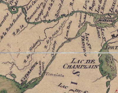
R. du RideauThis 1688 map [1910 copy] is one of the first to name the Rideau River. "Kataracoux" is today's Kingston and "Tonniata" is Brockville.
Franquelin, J. B. L. (1688) Carte de l'Amerique Septentrionnale: depuis le 25, jusqu'au 65⁰ deg. de latt. & environ 140, & 235 deg. de longitude / par Iean Baptiste Louis Franquelin, hydrographe du roy, à Québec en Canada. Retrieved from the Library of Congress, https://www.loc.gov/item/2002622264/. |
The Rideau Canal, opened in 1832, is the oldest continuously operated canal system in North
America. The original algonquian name for the Rideau River is Pasapkedjiwanong, meaning the river that passes between the rocks. The word rideau is French for curtain. This was the appearance of the twin falls of the Rideau River, where it meets the Ottawa River, to Samuel de Champlain who travelled up the Ottawa River in 1613. The name R. [Rivière] du Rideau first appeared on maps in about 1688.
The plan to construct a navigable waterway between Lake Ontario and the Ottawa River was conceived after the War of 1812 (you remember; the war where Canada beat back the invading Americans). It was
designed to provide a secure supply route from Montréal to Kingston,
avoiding the vulnerable St. Lawrence River route. Today we welcome the invading Americans to journey its scenic route.
As you travel along the Rideau you will see most of the stonework
and many of the buildings as they were in the 19th century.
In 1826, Lieutenant Colonel John By
of the Royal Engineers was assigned to design the canal and to supervise its construction.
Colonel By faced a stiff challenge, to create a navigable waterway
between the Ottawa River and Kingston, through what was at the
time a wilderness of rough bush, swamps and rock terrain, funded
by an awkward system of British parliamentary grants.
Initial construction of the Rideau Canal started with preparing the area for the Ottawa locks in the fall of 1826. Major construction on the rest of the route started in 1827. By November 1831 construction had essentially been completed with 47 masonry locks and 52 dams* creating a 202 km (125 mile) waterway, one of the greatest engineering feats of the 19th century.
Although chastised by the government for cost overruns, Colonel
By had created one of North America's best navigable waterways.
The exquisite stonemasonry of the control dams and locks are admired
by waterway travelers to this day.
* The number of 52 dams is from Robert Legget, author of Rideau Waterway, who counted all the dams, weirs and berms of the Rideau. That number was confirmed by the Chief Engineer of the Rideau Canal in 2005. The number of main dams in 1832, ones located at lockstations, is 17 - 11 made of stone, 8 made of wood (Lt. Edward Frome, R.E., 1837).
The Beginning
[ For more details about the early surveys and what the "Rideau Route" looked like prior to the building of the Rideau Canal, see the Rideau Route section of this website. ]
The history of much of early Canada
starts with water. Many communities were formed at the foot of
rapids, a natural spot for river travelers to stop. Montréal for
instance, one of the great cities of Canada, was founded at the
foot of the Lachine Rapids. In the same way, Hull was founded
by Philemon Wright in 1800 at the foot of the Chaudière Falls,
on the north side of the Ottawa River. Across from Hull, on the south
side of the Ottawa, the Rideau River cascaded down in a beautiful set
of twin falls.
The Rideau route was only known to
natives who used portions of it to travel from Lake Ontario to the Ottawa River.
The earliest written report is a survey expedition initiated by
the British government in 1783 when Lieutenant Gershom French, led by a native guide, traveled
from Montréal, up the Ottawa River to the Rideau Falls, up the
Rideau River to its source in the Rideau Lakes, down through the lower Rideau lakes into the Gananoque River system (which is where the central Rideau lakes flowed to at that time), to the St. Lawrence at Gananoque. The route to Kingston as we know it today was non-navigable (there was no direct connection between the southern Rideau lakes and the Cataraqui River), Lt. French had to get to Kingston by paddling up the St. Lawrence River.
During the war of 1812, naval strength
was a major issue. The naval shipyards at Kingston were critical
to Canada's defence, and a secure supply route from Montréal to
Kingston was crucial to any war effort. After the war ended, it
was revealed that the Americans had been hatching a plan to cut
off access to the St. Lawrence. So it was that in 1816, Lieutenant
Joshua Jebb of the Royal Engineers was given the duty of surveying
a route for a navigable waterway which in part was "to
follow up the course of the Cataroque [sic] from Kingston Mills, and,
keeping a northerly direction, to penetrate into Rideau Lake,
and descend the river which flows from it to its confluence with
the Ottawa." Jebb also surveyed a secondary route via Irish Creek and in his final report he recommended the Irish Creek route over a route going through the Rideau lakes.
It was four years after Lt. Jebb's survey, that a prominent figure,
Charles Lennox, the Fourth Duke of Richmond, and the Governor-in-Chief
of British North America decided to make a tour of the Canadas. This
included an inspection of the planned route of the Rideau Canal. In 1819, he started his tour, leaving Québec City, travelling
to Montréal, and on to Kingston. From Kingston he headed overland,
along rough tracks and trails, until he eventually reached the
new community of Perth, on August 21.
Unfortunately, the Duke had been bitten by a soldier's pet fox in Sorel (near
Montréal) two months previously, and it was in Perth that the symptoms
of rabies first appeared. He was able to continue on to the new settlement
of Richmond, but a day later, in a settler's cabin near Richmond, he died. Prior to
his death, he had managed to get an important British figure, the Duke of Wellington,
who at the time was the Master-General of the Ordnance (the branch of the government
in charge of fortifications and canals), interested in the Rideau Canal project. Wellington wrote a memorandum on March 1, 1819 which, in part, advocated that the Rideau Canal should be built as part of the defence system for Canada.
No action was taken on
the Duke of Wellington's recommendations to proceed with the
building of the Rideau Canal. The next activity was in 1821 when
the legislature in York appointed a commission
to look into improving the internal navigation of the province.
The Rideau was part of this commission, which made its report
in 1824. The commission hired Samuel Clowes, a civil engineer,
to make a detailed survey and cost analysis. Clowes conducted surveys of the Rideau route in 1823 and 1824. His results ranged
from a ludicrously low estimate of £ 62,258 for small
4 foot deep locks, to an equally unrealistically low £ 230,785 for a system with locks 100 feet long by 22 feet wide. These original
low estimates would come to haunt Colonel By when he was faced
with the task of actually building the canal. Clowes provided the first detailed level survey of the route and recommended taking the route via the Rideau Lakes as opposed to Lt. Jebb's 1816 recommendation of a route via Irish Creek.
The Start
In 1826, Lieutenant Colonel John By
of the Royal Engineers was handed the task of creating a navigable
waterway, with a minimum depth of 5 feet, from the Ottawa River
to Kingston, using the route suggested by Samuel Clowes. It was
a daunting task. The land through which Colonel By was to construct
the waterway was virgin forest and untouched rivers and lakes
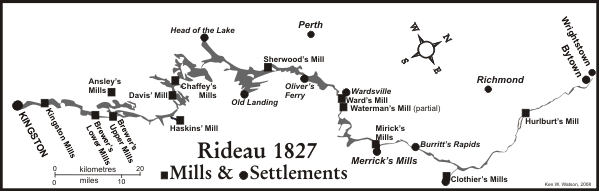
in a region that was very sparsely populated. As the following map
illustrates, the only significant communities in the area outside of Kingston and
Wright's Town (Hull) were the recently formed settlements of Perth and
Richmond. The other settlements shown on the map were quite tiny, usually
consisting of a mill and a dozen or so settlers.
Colonel By landed in Québec
City in May, 1826. He then moved and set up an office in Montréal
to make preparations and in September, accompanied by the Governor-in-Chief
of British North America, the Earl of Dalhousie, traveled to Wright's Town (Hull),
which at the time was a very comfortable settlement. On September
26, 1826 the two men stood on at the foot of Entrance Valley, selecting it as the spot for the start of the Rideau Canal. In doing so, they
founded what was to become Canada's national capital, Ottawa (originally named "Bytown").
The first order of business was to
re-survey the route and make specific decisions regarding what
was needed for the construction. The bush and swamps along the
initial part of the route proved so tough, that this job had to
be done in winter, when the frozen river could be more easily
traversed. In addition, a bridge was built linking Hull to the
south shore of the Ottawa. This was the first bridge to link Upper
and Lower Canada. The last but most important order of business
was to arrange the contracts for the actual construction of the
canal. This was done in Montréal, with all contracts being administered
by the Commissary General (an arrangement that was to cause many
problems for Colonel By).
The "Clerk of the Works" assigned to
Col. By was John MacTaggart. MacTaggart conducted the first survey of the Ottawa end of the canal in December 1826. In 1827 both MacTaggart and surveyor John Burrows conducted surveys along the entire length of the proposed route. MacTaggart came up with a couple of off the wall ideas, including building
a wooden aqueduct to cross Dows Great Swamp. This aqueduct was to be supported
by cutting off the tops of the many cedar trees in the swamp. MacTaggart was dismissed for intemperance in 1828 on the recommendation of Sir James Kempt and he returned to England where he wrote a book about his adventures called "Three Years In Canada".
The Construction
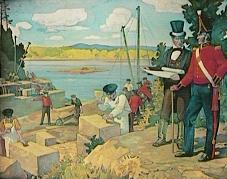 |
Colonel John By supervising construction of the locks at Bytown. Painting by C.W. Jeffreys. The painting now hangs in the Colonel By Lounge of the Chateau Laurier Hotel in Ottawa.
|
T
he Canal was constructed by thousands of labourers and tradesmen (carpenters, blacksmiths, stone masons, etc.), hired by independent contractors who were under the supervision of the Royal Engineers. Although the actual construction was done for the most part by these independent contractors, all the engineering design work was done by the Royal Engineers, much of this by Colonel By himself. Colonel By divided the Rideau into 23 work sections with the intent that a contractor should be able to complete the work requirement for a single section within a 2 year time span.
During the winter of 1826, several small contracts were given for forest clearing, excavation, and stonemasonry. Colonel By didn't agree with the original concept for locks being 108 feet long by 20 feet wide. He argued that the locks should be able to handle the new naval steamboats, and wanted locks that were 150 feet long, 50 feet in width, with a navigation depth of 10 feet (he later revised to latter down to 5 feet). A committee, headed by Sir James Kempt, was set up to study the issue and in June 1828 a compromise size of 134 feet long by 33 feet wide was finally agreed upon. Back in the summer of 1827, Colonel By gave the government a revised estimate of £474,000 to build the canal and the main contracts for construction were awarded. After the increase of lock size was approved in 1828, By submitted a revised estimate of £576,578.
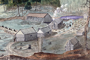 |
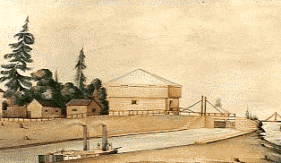
| Construction Camp at Upper Brewers in 1829, by Thomas Burrowes, 1829, Archives of Ontario, I0002186 |
During construction, many problems with the contractors arose, particularly with the excavation contracts. Several contractors couldn't live up to the term of their contracts and had to be dismissed. The unskilled labour used for these jobs was generally unruly and the some of the Royal Sappers and Miners had to be used to guard the stores and closely supervise much of the work. Conditions were difficult, the Rideau was a sparsely settled frontier at the time. Construction camps consisting of log buildings were built by the contractors at the work sites. Local settlers were involved in helping to supply these camps with provisions. Provisions were also shipped in from as far away as Montreal. It was a mammoth undertaking.
All the work was done by hand with the aid of a few draft animals (oxen and horses). Most of the excavations were carried out by men with shovels, pickaxes and wheelbarrows. Rock was laboriously hand drilled and blasted with either merchant powder (a somewhat unstable mix of nitre, sulphur and charcoal) or black powder. The large stones that make up the locks were set in place using simple hand cranes. Much of the skilled rock work was done by French Canadians who had experience on other lock projects and British Isles stonemasons. The unskilled labour was generally made up of Irish immigrants and French Canadians. The Irish made up about 60 percent of the labourers, most were recent immigrants looking for wage work, which was very scarce to find in those days. The other 40 percent were made up mostly of French Canadian labourers, many pulled from existing timber camp labour forces. It is estimated that 2,000 to 4,000 men per year worked to make the Rideau Canal a reality.
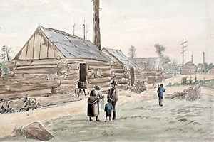 |
| Log Houses of workers at Long Island, 1830 - by James Pattison Cockburn, August 17, 1830, Library and Archives Canada, C-040048 |
It is difficult to fully appreciate today the difficulties that were faced. Not only by the men working on the job, but in many cases their families. Several of the Sappers and Miners had their families stationed with them. Some of the Irish labourers brought their families to the work sites, building rough shanty cabins. Others left their families in the newly created Bytown or the more established town of Kingston. We don't know much about the families on the work sites since the official records generally don't mention them. Some places, such as the work site at Kingston Mills, grew into small communities. A census done in November 1830 shows 101 buildings located on the site, including three licensed public houses (O'Reilly's, Franklin's and Mahoney's), a Catholic chapel, a store, and a schoolhouse.
There were deaths during construction, mostly from disease. Contrary to today's popular beliefs, the number of accidents was low for a project of this magnitude in this time period. We know from the records of A.J. Christie (hired by John By to look after the medical needs of the workforce in 1826 & 1827) that, in 1827, the first full year of construction, a total of 17 men died - 10 of disease and 7 from accidents. In that year 6 women and 38 children also died along the canal. On a more positive note, Christie also recorded 54 births. We also know that during the entire construction period, 22 of the Royal Sappers and Miners died, 5 from blasting related accidents, 1 by drowning and the remaining 16 died of sickness or have no cause given for their death.
The Montreal Herald reported in its December 15, 1827 edition "The last advices from the Rideau Canal, we regret to state, mention the occurrence of a number of distressing accidents. Two labourers have been smothered by a bank of clay falling on them at Hog's Back. ... Considering, however, the extent of the works, and the dangerous nature of many of them, there have been fewer accidents since the commencement, than could have been supposed. Two have be before this killed by blasts ... and one killed by a tree falling on him."
When a death by accident occurred an inquest was held to determine the reason. A number of the accidents were self-inflicted, a result of alcoholic overindulgence. An inquest held into the death of John Rusenstrom, killed in a fall from the Hogs Back dam, found that his death was the "consequence of intoxication by Ardent Spirits". Patrick Sweeney, a construction labourer at Old Sly's, drowned while trying to swim across the Rideau River to obtain another bottle of whiskey. He was inebriated when he made the attempt. In the August 1831 inquest into his death, the coroner stated: "When last seen alive, he was going down with a bottle or flask in his mouth." William Ferguson, a fellow labourer, "after returning from the [Sweeney's] funeral, expired in the open streets at Smiths' Falls, in the arms of his fellow workmen". The jury in the inquest into his death concluded that it "was caused by intemperance."
Cemeteries were established near each worksite. In some cases, existing cemeteries such as McGuigan Cemetery near Merrickville were used, in others, new cemeteries were developed. Funerals were held for fallen workers and the graves marked with wooden markers and fieldstones. Today, only the field stones remain, leading to the myth of mass burial in unmarked graves. This was not the case, the mores of the day dictated that bodies be buried with respect and this is how it was done.
By far the largest cause of death was disease and the biggest culprit was malaria. It is to be noted that malaria on the Rideau, contrary to popular myth, was not brought in by the soldiers working on the canal. It was already prevalent in settled areas Ontario at that time (going back to at least the late 1700s), in areas where the anopheles mosquito was present. In 1826, prior to the start of construction on the Rideau, malaria was already present in both Kingston and Perth. Today we've forgotten that malaria (often known as ague) was endemic in the southern regions of Ontario up until the late 1800s.
Malaria is a parasite that comes in several forms. We think of malaria today as a tropical disease, and in the tropics it is a deadly form of malaria called Plasmodium Falciparum that is most commonly present. But in Ontario (and northern U.S., southern England and in Europe) at the time it was a temperate form, a much less deadly type known as Plasmodium Vivax (P. Vivax), that was present.
Malaria needs both people and a certain type of mosquito to survive. That mosquito is the anopheles mosquito, a dusk and dawn biting mosquito that will bite a human more than once (it both delivers and picks up the malaria parasite). When a mosquito infected with malaria bites a human, it injects the malaria parasites into the bloodstream. Those then head to the liver to incubate. Once sufficient numbers have been reached they head back into the blood and infect red blood cells. They multiply in the blood cell, eventually bursting out en-masse. This causes the classic fever & chill symptoms of malaria. It also affects the mortality rate, temperate P. Vivax infects a small percentage of the blood cells (only new blood cells) and today has a 0% mortality rate. Tropical P. Falciparum infects far more red blood cells and therefore has a high mortality rate.
We know that malaria was on the Rideau prior to the start of construction. There are many reports in the Rideau area, from the early 1800s, of settlers suffering from malaria. In a diary entry for April 1827, the Reverend William Bell of Perth stated that "Repeated attacks of ague have left me reduced in body and discouraged in mind." The effective prophylactic for malaria is Quinine. Chincona bark had been used for centuries for its quinine content, with limited effect. It was the isolation of quinoline alkaloid in 1820, named Quinine, that proved to be a potent anti-malarial drug. But, during the construction of the canal in 1826-1831, Quinine was difficult and expensive to obtain, supplies coming to Canada were very limited. Reverend Bell knew this and would send his son to Montreal to pick up new supply when it arrived from Europe. Malaria was present in York (Toronto) at the time with the papers carrying ads, such as the January 1827 ad in the Canadian Freeman for "Ague Powders" stating "Have just received a fresh supply of QUININE, - so celebrated as a cure for the Ague, which they warrant to be pure and genuine."
The mystery on the Rideau is explaining the apparent 2 to 4% mortality rate from malaria since P. Vivax today has a very low mortality rate. The most likely explanation for this is complications from other diseases, and health issues such as dysentery, that were common in that day. It may have been fatal for someone in an already weakened state to contract P. Vivax malaria. About 60% of the workers in the southern Rideau contracted malaria each year. An alternate, but less likely explanation for the mortality rate, is that another form of malaria, P. falciparum, a virulent form of tropical malaria, was also present. But since it couldn't survive the Canadian winter, it would have had to have been imported into the worksites each year, in sufficient numbers to create an epidemic, a highly unlikely proposition.
The first big attack of malaria came in the summer of 1828, an exceptionally warm spring and summer that provided perfect conditions for the anopheles mosquito. The period from August to mid-September became known as the "sickly season". The construction of the canal put hundreds of people in close proximity to each other, aiding in the transmission of the disease. It was not known at that time that mosquitoes transmitted the disease, it was though to be the result of bad air (from which the name “malaria” is derived). Colonel By had large sections of trees cut down at each work station to improve air flow, in order to (he thought) lessen the chances of malaria.
Extrapolations from the factual records which have survived, indicate that perhaps about 500 people died of malaria. For instance, in 1830, in the area from Newboro to Kingston Mills, out of a total of 1,316 men, 787 got sick and 27 died. At the same time, 13 women and 15 children were also recorded as having died. A rough guess is that perhaps upwards of another 500 died from other diseases (dysentery, small pox, tuberculosis) and accidents (blasting accidents, rock falls, drownings, etc.). So today, the round number of 1,000 is generally used for the number of deaths (men and family members), with the biggest killer being various diseases of the day. That number is a top end, the bottom line is that we don't really know (the records are too fragmented to determine an accurate number).
Over the years, many of the old burial grounds have faded into history. Three have been maintained on the Rideau; McGuigan Cemetery near Merrickville, the Old Presbyterian Cemetery at Newboro, and the cemetery at Chaffeys Locks. In addition, memorials to these fallen workers have been erected in Kingston and Ottawa and at several spots along the canal. For more information about death and burial during the construction of the Rideau Canal, see the story "A Grave Revealing"
Coming back to the construction of the canal, the settlement on the south side of the Ottawa River was growing. Colonel By had streets and building lots surveyed and the community became known as Bytown. It was renamed Ottawa in 1855 and was chosen as the site of Canada’s capital by Queen Victoria in 1857. Many of the Royal Sappers and Miners were camped in barracks built for them on Barrack Hill (now Parliament Hill). In 1829, a company of Sappers and Miners that had been stationed in Bytown were moved to new barracks in Newboro to assist in the construction at that site.
Colonel By made a decision to turn the Rideau into a slackwater system which meant flooding the regions between one lock and the next to navigable depths. It meant the construction of water control dams in addition to the locks. Several of these dams became some of the major engineering triumphs of the 19th century (including the Hogs Back Dam which collapsed three times before it could be completed successfully).
Although Colonel By had problems with several of his contractors, he also worked with some of the best. Five of these were Robert Drummond, Thomas McKay, John Redpath, Andrew White and Thomas Phillips. The latter four contractors entered into a partnership for their work on the Rideau, pooling their financial resources and splitting the profits four ways. All four had prior canal building experience, working on the first Lachine canal. Their work on the Rideau was exceptional and By had nothing but high praise for these men.
The main task given to Redpath was the daunting job of the construction of the dam at Jones Falls. He is perhaps best known today for "Redpath Sugar" which got its start as the largest sugar refinery in Montreal, built by Redpath in 1854. McKay started work on the Rideau by constructing the stone arches for the Union Bridge, the first bridge linking Upper and Lower Canada. He then went on to construct the magnificent flight of eight locks at Ottawa. After his work on the Rideau he stayed in Bytown, building a house for himself, Rideau Hall, now the Governor General for Canada's home. He built the first courthouse in Bytown as well as several mills. Robert Drummond constructed the locks at Kingston Mills. He also completed the locks at Upper and Lower Brewers Mills after the first contractor failed and also at Davis' Rapids, in partnership with John Haggart, after the first contractor there also failed. White and Phillips worked on several of the locks, including the dam and locks at Long Island.
The Triumph and Failure
The Rideau Canal is obviously a major
triumph of engineering, a system that has worked well since it first opened in 1832, and looks like it will work well for the next several centuries.
There were several trials and tribulations along the way, a good
example being the Hogsback Dam. In order to build a slackwater
system, several dams had to be built to hold back the water and
flood part of the system to navigable water depths. One of the largest
of these was the dam proposed for Hogsback Falls. It was to be
45 feet high, which was considerably higher than the largest similar
dam built in the U.S. at that time, which only stood 28 feet. It also had to
be built across a fast flowing river, an engineering feat with
few precedences.
In 1827, a contract for the dam was awarded to Walter Fenlon. Work progressed through to February, 1828, when, unfortunately, the sudden rise of early spring floodwater swept most of the dam away. He tried again, but rising flood waters in early April washed the dam away again. Fenlon asked to be released from his contract and he was granted that wish in November of that year. Colonel By decided that rather than re-contracting the job, he would use men of the Royal Sappers and Miners and hire his own labour force.
Work on the stone dam progressed well through a severely cold winter and the water had been raised by 37 feet, only four feet from the required level. However by the end of March, 1829, leaks began to appear in the dam. Clay fill, employed in freezing weather, was beginning to fail. Colonel By was summoned from Bytown to supervise control measures to salvage the dam. One of his letters tells the harrowing tale of the failure, on April 3, 1829, as Colonel By was standing on the dam. He wrote that he "was standing on it with forty men employed in trying to stop the leak when I felt a motion like an earthquake and instantly ordered the men to run, the Stones falling from under my feet as I moved off".
Plans to build a cut stone dam were abandoned. The cribwork coffer dam built by Philemon Wright was still standing and it was decided to extend this structure the full width of the river and built it up to the required height. To facilitate the transport of the large quantity of stone needed from the quarry, the Royal Engineers had a 1,160 foot long "rail road" constructed in the spring of 1829 from the quarry to the dam. The new timber crib dam was completed by the end of year 1829 and the water was raised to its full height. (see the story Washed Away for the full details)
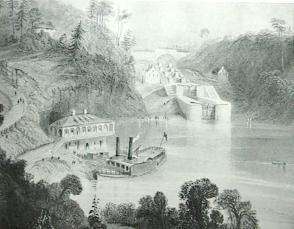
Stone dams were built successfully at several location along the Rideau, the largest is the engineering marvel located at Jones Falls. This stone arched dam, one of the first built in North America, spans a length of 350 feet at the top (100 feet at the bottom) and the stonework, together with the berm in front of it, has a total height of 61 feet. It was built from local sandstone under a contract with John Redpath. Over 200 men, including 40 masons, worked on the dam and locks. This was one of the worst areas for malaria and during the summer of 1828, everyone in the camp, including the doctors, were suffering from "swamp fever".
The beautiful arched dam at Jones Falls
and the four locks (a staircase of three locks, a turning basin,
and a fourth lock, with a total lift of 60 feet) are one of the
jewels of the Rideau, a must see for any visitor. It epitomizes
the triumph of engineering that the Rideau system represents.
The Defence of the Canal
 The defence of the canal itself was of primary importance to Colonel By. The Canal, designed as a military supply line, was itself vulnerable to attack. Accordingly By put forward a proposal to purchase additional land and construct several blockhouses. The cost estimate for this work was £ 69,230 (about 2.6 million dollars today). By submitted his proposal to the Ordnance in March of 1830. The Ordnance made a decision that due to the high cost of the canal, any defensive works would have to be postponed. However they neglected to inform Colonel By of this decision until the spring of 1832.
By, hearing no word from Ordnance, and knowing that the defence of the canal was extremely important, contracted the construction of several blockhouses. Only four were completed, at Kingston Mills, the Isthmus (Newboro) at the summit of the Canal, the Narrows on Rideau Lake, and as shown in the watercolour above, Merrickville. The painting, done by Capt. H.F. Ainslie, 25th Regiment of Foot, shows the blockhouse at Merrickville as it appeared in March, 1839.
The blockhouse at Merrickville was extremely important to the defence of the canal. An early defence strategy had been to maintain a wilderness buffer around the Canal. This would prevent easy access by enemy troops to the canal works. However, in 1832, the provincial government began to upgrade the Prescott Road, providing easy access between the St. Lawrence and the Rideau. In the event of hostilities, the blockhouse at Merrickville would become a key defence point.
The Canal never saw military activity. The blockhouse at Merrickville serves as the lockmaster's residence until the late 1800s. Following the Upper Canada rebellion of 1837-38, wooden guardhouses were built at Jones Falls and Morton, and stone defensible lockmaster's houses were later built at several of the locks along the canal. No new blockhouses were constructed.
Completion
 The construction of the canal was essentially complete by November 1831 although work in the southern section continued through to the spring of 1832. In December the two companies of Sappers and Miners were disbanded and several of the soldiers were given the position of Lockmaster on the newly built locks. On May 22, 1832, Colonel By, his
family and some fellow officers boarded the steamboat Rideau (also know by its nickname of Pumper), in Kingston for the grand opening voyage. It was
on May 29, after stops at all the small communities along the
way, that the Rideau sailed into Bytown. The canal was open. Pictured
to the left are the Ottawa locks as they appeared in 1839 from
a drawing by W.H. Bartlett (from Legget).
The construction of the canal was essentially complete by November 1831 although work in the southern section continued through to the spring of 1832. In December the two companies of Sappers and Miners were disbanded and several of the soldiers were given the position of Lockmaster on the newly built locks. On May 22, 1832, Colonel By, his
family and some fellow officers boarded the steamboat Rideau (also know by its nickname of Pumper), in Kingston for the grand opening voyage. It was
on May 29, after stops at all the small communities along the
way, that the Rideau sailed into Bytown. The canal was open. Pictured
to the left are the Ottawa locks as they appeared in 1839 from
a drawing by W.H. Bartlett (from Legget).
The only blight on the whole affair
of building the canal was the final cost of £ 822,804 (as of January 1834 when the final land acquisition costs were known). Cost estimates had increased steadily as design parameters and construction details were refined. In early 1828, when the final lock dimensions of 33 feet wide by 134 feet long had been decided upon, By submitted a cost estimate of £ 576,757. This estimate did not include any costs for constructing military works along the canal.
In 1831, once actual details of construction
were known, Colonel By submitted a detailed revised estimate
of £ 776,000, which was considerably
more than parliament had originally allocated for the project.
However problems, such as the failure of the Hogsback Dam and unanticipated land acquisition costs increased
this estimate. There were also some accounting irregularities
by the Board of Ordnance. It should be remembered that in those
days, a simple request by By for stationary supplies (quills,
paper) took six signatures and two months to process.
By's recall notice (Treasury Minute dated May 25, 1832) included costs to December 31, 1831 which totalled £ 715,408 which was £ 22,742 more than had been granted by Parliament to that time. That same cost sheet shows By's estimate for all in costs to complete the canal by May 1, 1832 to be £ 803,774, which the Treasury Minute points out would be £ 83,358 above the parliamentary grants (which ceased in 1831).
By submission of £777,146 as the cost of the canal to August 31, 1832 was quite close to his 1831 estimate. The final figure of £ 822,804 as of January 1834 was mostly due to the cost of land acquisition settlements. Land acquisition settlements were made according to the Rideau Canal Act (1827) which stated that non-voluntary settlements were to be made by arbitration or by jury, a process that took some time.
A question often raised is what do those cost figures mean in terms of today's dollars. The replacement value placed on all the “assets” of the Rideau Canal by Parks Canada is over $929 million dollars (2012 valuation by Parks Canada of the built assets). This figure does not include such things as the 19 km of required canal cuts, channel dredging, surveying and route clearing that would also be required if the clock could be turned back to a pre-canal era. Bottom line is that it would be easily be a billion dollar plus project today.
At the exact moment that Lt. Colonel By was passing through Smiths Falls, on May 25, 1832, on his inaugural trip through the newly completed Rideau Canal, a British Treasury Minute (official memorandum) was being penned in London, ordering By's removal from command and his recall to England. It should be remembered that this was the time of parliamentary reform in Britain. A reform government had taken power in November 1830. This government was against spending British tax dollars on defence projects for the colonies (which included Canada). Hearings were held into the expenses of the Rideau Canal. Parliament was not so much upset at the cost overrun as they were at the Board of Ordnance's defiance of parliamentary authority by authorizing By to complete the project regardless of the actual amount of the parliamentary grants.
By was caught in the middle of a political battle, the Treasury Minute specifically blamed By for defying Parliament, rather than, as should have been the case, the Board of Ordnance. Although every hearing had exonerated By, he was caught in the middle of the politics of the day, he never received formal commendation in recognition of the tremendous feat he had accomplished.
Colonel By died in 1836 at the age of 53, his achievements, the building of the
Rideau Canal, the founding of Bytown (Ottawa) not publicly recognized.
[For the full details of By's fall from grace, see the story Bye By]
In further defence of By, it should be noted that Canal cost overruns were the order of the day. The Ottawa canals, which took 15 years to complete, had a 60 percent cost overrun. The Welland Canal took almost 10 years to complete and went 55 percent over budget. The Caledonian Ship Canal took 19 years to build and had a cost overrun of 87 percent. In contrast, the Rideau was built in only five years, and against the June 1828 estimate, was less than 43 percent over budget. In fact, the final cost was only 19 percent over By's March 1830 supplementary budget that had been accepted by the British parliament. In addition, the Rideau was so well built that maintenance costs in subsequent years were considerably lower than other canals built during the period.
As the Years Went By
When the canal was completed, forty
of the Royal Sappers and Miners who helped build the canal were
given land grants along the Rideau. Several of these men also
became the first lockmasters. The Canal remained under the control
of the British Ordnance Department until 1856 when the provincial
board of works assumed responsibility for the canal. In 1868 responsibility
was transferred to the federal government, the Department of Railways
and Canals (later to be called the Department of Transport)
eventually taking control of the Rideau Canal. In 1972,
control of the Rideau was transferred to the Canadian Parks
Service, now called Parks Canada, then part of the Federal Department of
Canadian Heritage (today under the Department of Environment). The Parks Canada staff continue to maintain the heritage
and the original spirit of the Rideau to this day.
Although the Rideau was never directly used for its intended purpose, a military supply route in time of war, it acted as a significant military deterrent to future hostilities. In addition, when opened in 1832, it quickly became a commercial success. It was the commercial lifeline for the port of Montreal, with thousands of tons of heavy materials (wood, minerals, grain, etc.), transported by boat from Canada's hinterland, via the Rideau Canal and the Ottawa River to Montreal. Also, in its first years, thousands of immigrants destined for Upper Canada travelled by boat via the Rideau Canal. The 19th century saw continued commercial use of the canal in transporting products from local sources: farming, lumbering, mining, milling of various types (grist, lumber, carding), cheese factories, distilleries, and other small businesses that were operating in the region.
[for full information about the significant role of the Rideau Canal in immigration and early commercial use see Robert B. Sneyd's articles: Rideau Boom Years: Commercial Success and Rideau Boom Years: British Immigration to Upper Canada, 1832-46.]
The St. Lawrence at this time was difficult
to navigate upstream against the rapids. So it was that by 1840,
many vessels were traveling from Montréal to Ottawa and through
the Rideau Canal to get to the Great Lakes. However by the
1850s, ship technology had improved to the point that steamers
could make it up the St. Lawrence under their own power and traffic
on the Rideau dropped off. It was at this time that the railroad
boom in Canada was going on, and little railroads were springing
up all over. The Rideau played a part in this, working well in
conjunction with small railroads in the region to move goods.
By 1875, Canada was experiencing the "age of railroads." However this didn't have a large impact on the Rideau since most of the local heavy goods were still being transported by barge along the canal. In fact, when the Canadian Pacific Railway decided to make Smiths Falls its main junction in eastern Ontario, coal for those trains was shipped across
Lake Ontario from the US and then loaded onto barges in Kingston and
brought up the Rideau to Smiths Falls. This lasted until early
in the 20th century when it became cheaper to bring the coal in
by train.
As the 20th century progressed, the
current use of the canal, a waterway route for pleasure boats,
came to the fore. The Rideau had been used for pleasure since
its early days. The drowning of lands for navigation resulted
in the creation of ideal habitat for bass. By the late 19th century,
the Rideau region was renown across North America for its exceptional
bass fishing. Several lodges sprang up catering to the sportsman,
and a thriving business grew up with boats and guides taking the
avid fisherman to the bass hot spots. Lakes such as Sand, Opinicon,
Indian, Clear, and Newboro became prized fishing destinations.
Through the first half of the 20th
century, these lodges thrived on fishing. It was at this time
that boating on the Rideau changed again. The introduction of
the internal combustion outboard motor engine heralded a new era
in boating. It allowed the individual to easily go out on his
own. New types of boats, motor launches, built by the likes of
Chris Craft and Peterborough began plying the Rideau. Summer homes
started to be built along the shores of the Rideau. Marinas started
to replace the lodges as destinations for the Rideau tourist.
In 1925, the Rideau was designated a National Historic Site of Canada (plaqued in 1926, 1962 and in 2013).
By the 1950s, the Rideau had turned into
the waterway as it can be seen today. Cottages dot the shores
of many lakes, with small runabouts, canoes, and sailboats enjoying
the tranquil waters of the lakes. Larger cruisers from across
North America travel the full route of the Rideau, traveling from
lock to lock, stopping to enjoy a picnic on a rocky knoll under
the shade of a large pine tree.
In the 1960s with the approach of Canada’s 100th anniversary, there was a growing recognition by government of the heritage value to Canada of the Rideau Canal. Several of the blockhouses along the Rideau were rehabilitated at that time.
The biggest change came in 1972 when the Rideau Canal was transferred from the Department of Transport to Parks Canada. At that time, the government gave direction to Parks Canada stating that "under the Conservation Program there should be a shift in emphasis in the management of the canal systems from "transportation" to historic restoration, preservation and interpretation; natural environmental preservation and interpretation and the optimum use of federal lands." The 1970s and 1980s saw a great deal of heritage work done by Parks Canada.
In 2000 the Rideau Canal was designated a Canadian Heritage River in recognition of its outstanding historical and recreational values.
In 2007 it was inscribed as a UNESCO World Heritage Site recognizing it as a work of human creative genius. The Rideau Canal was recognized as the best preserved example of a slackwater canal in North America demonstrating the use of European slackwater technology in North America on a large scale. It is the only canal dating from the great North American canal-building era of the early 19th century that remains operational along its original line with most of its original structures intact. It was also recognized as an extensive, well preserved and significant example of a canal which was used for military purposes linked to a significant stage in human history - that of the fight to control the north of the American continent. (see World Heritage page).
The Future
In an ideal future, the next centuries will see the Rideau as it is today, with people enjoying the pleasure of boating its tranquil waters, visiting the historic lockstations and learning about this significant part of our Canadian heritage.
The Rideau Canal faces many pressures including inappropriate development along its shorelines and lack of support by government. It was hoped that the World Heritage Designation for the Rideau Canal in 2007 would have brought more government support to present and protect the heritage of the Rideau Canal, but this has not been the case. In 2012, as a result of budget cuts by the Government of Canada, Parks Canada cut the budget of the Rideau Canal by 20% and removed most of the heritage support for the canal. In 2015-16, infrastructure programs were announced that focused on fixing up much of the built heritage in need of repair. However, heritage presentation and education are still lacking.
It is hoped that in the future, the Canadian government will come to recognize the value of the Rideau Canal to Canada. One reason why the Rideau is important for Canada was perhaps best stated by the Auditor General, Sheila Fraser, in her 2003 report, which discussed Canadian heritage sites such as the Rideau Canal:
These places recall the lives and history of the men and women who built this country, and they foster awareness of how Canadian society evolved. They help us to better understand the present and prepare for the future. They contribute in important ways to Canadians' sense of belonging to their community. When important parts of Canada's built heritage are lost, future generations of Canadians are deprived of access to key moments of their shared history.
So it is hoped that future generations of Canadians will be able to enjoy the Rideau Canal just as we do today.
|