Your location: Rideau Canal Home Page > Ecology of the Rideau > Shaping of the Rideau
 The Shaping of the Rideau
by Ken W. Watson
| The following is a slightly abridged version of a section from the book "ENGINEERED
LANDSCAPES - The Rideau Canal’s Transformation
of a Wilderness Waterway" by Ken W. Watson, 2005
|
Climate and geology are the main contributing factors to the geography of the Rideau Route - the Rideau River, Gananoque River, Cataraqui River and the Rideau Lakes. The southern part of the Rideau Route (Rideau Lakes region) contains exposures of very old rocks (Precambrian) of the Canadian Shield, known as the Frontenac Axis. To the north and south of this area are younger sedimentary rocks.
The most recent period of glaciation in North America is known as the Wisconsin Period. In the Rideau Route area, it first took hold about 90,000 years ago, and ended about 13,000 years ago. At its height, about 20,000 years ago, the Rideau Corridor was sitting under ice up to 1.5 kilometres (1.0 mi) thick. The ice polished and moved rocks, excavated some of the landscape. The weight of the ice depressed the landscape by about 175 m (575 ft) below where it is today.
As the ice retreated, the landscape underwent progressive changes. The retreating glaciers left behind deposits of glacial till, boulders, gravel, sand, silt and clay. With the landscape depressed below sea level, salt water from the Atlantic Ocean flooded in to create the brackish Champlain Sea. The southern limit of the Champlain Sea on the Rideau Route was in the vicinity of Rideau Ferry. Whales swam in this sea, the bones from a Humpback whale were found near Smiths Falls.
Several of the Rideau lakes are the result of the glaciers gouging out slightly softer crystalline limestone rock units, leaving depressions for the lakes to form in. Tectonics was also an influence on several of the lakes, an example being the northern Rideau lakes (Big, Upper and Lower) that follow the trace of the aptly named Rideau Lake Fault. The presence of rapids can be attributed in several areas to locations where the river or creek crossed over more resistant rock units. For instance, the head of the original Jones Falls Rapids is underlain by a resistive quartzite unit.
When the glaciers retreated, the bedrock, released of their weight, started to rise, a process known as isostatic rebound. This occurred in the southern part of the Rideau Route before it did in the northern part of the Rideau Route. The earlier retreat in this area and the direction of retreat has resulted in more mature development of the rivers in that area. The Gananoque and Cataraqui river systems both have a greater gradient and more mature development than the Rideau River.
The Rideau River is underlain by soft silt and clay sediments, deposited by the Champlain Sea on top of glacial till which in turn lies on top of relatively flat lying sedimentary rocks. This gives the Rideau River section a very different appearance than the central and southern Rideau Route, most particularly the almost complete absence of lake development, a poorly developed stream drainage system and many swamps.
The central and southern portions of the Rideau Route are characterized by an increase in topographic expression and extensive lake development. This extends south on the Rideau to Kingston Mills, which marks the southern extension of the Canadian Shield on the Rideau Route. Kingston Bay and the City of Kingston are underlain by flat lying younger sedimentary rocks. The central portion of the Rideau Route lies close to the eastern boundary of the Frontenac Axis and many of the stones used to build the dams and locks, such as those as Jones Falls, were taken from flat lying Palaeozoic sediments (sandstone) located just to the east of the central Rideau Route lakes (in this case, Elgin). These flat lying sedimentary rocks also provided for ideal farmland that helped to shape the cultural history of the area.
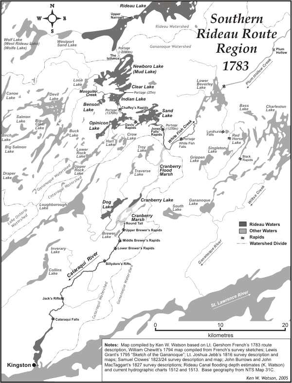
The Rideau Route in the pre-settlement era spanned three watersheds, the Rideau River watershed, the Gananoque River watershed and the Cataraqui Creek watershed. The main dividing line then, as now, was the height of land running through Newboro. Water to the north of this height of land flowed north, to join the Ottawa River, water to the south flowed south, to the St. Lawrence River and Lake Ontario. The main difference in the pre-settlement era was that the central Rideau Lakes (Newboro, Clear, Indian, Opinicon and Sand) drained not to the Cataraqui River, but to the Gananoque River, via White Fish Creek.
In the pre-settlement era, the Rideau Route region was heavily forested. When surveyor John Stegman surveyed Montague Township in 1797 he noted the types of trees he encountered on his survey. Glenn Lockwood in his book "Montague, A Social History", 1980, produced a table showing the frequency of these trees. The top 5 were Elm (18.2%), Maple (15.8%), Basswood (12.6%), Cedar Swamp (9.9%) and Tamarack Swamp (6.4%). There was only a 2.2% reference to “Meadow”, the rest of the land was either heavily forested or swamp.
Lt. French in 1783, in the area just north of Hogs Back, found that the land was “Timbered with Maple, Beech, Birch, Elm, Butternutt &c. with an Edging of Cedar and Pine always covering the Banks of the River and where the water is Rapid, the Shores are Lined with Lime-Stones.” In the section south of Merrickville, French wrote: “Drowned Swamp about 50 Rods Broad on each side of the River, behind which the land raises high, with a gravely soil. Timbered principally with Beech, and Stony, but not to that Degree as to render it unfit for Cultivation. A party sent out on each side to the distance of two miles, Reported they had found no Stones, more than half a mile back, and that the Soil was good.” At Newboro Lake he saw “The points setting into the Lake are Rocks and Stones, Timbered with Hemlock” but as he proceeded south through Indian, Opinicon and Sand lakes he found “The Lands laying in the Route is Intirely too rocky to Cultivate, the Timber is Pine, Cedar and Mountain Oak, the whole bad of its kind.”
The heavy forest cover meant that water retention in the surrounding lands was far higher at the time of canal construction, before most of the forests were cut down for merchantable timber and/or to create farmland. This water retention had an impact on the design of the canal since there was sufficient water capacity in the watersheds that reservoir lakes were not needed. As the forests were removed, mill dams on watershed lakes played a role in maintaining reservoir capacity, but by 1865 more water retention was needed and the first government dam was erected at the outlet of Eagle Lake. This was soon followed by other government dams, leading to the reservoir system that is in place today.
Comments: send me email: Ken Watson
©1996- Ken W. Watson
|