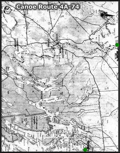
CANOE ROUTE 4A-74
Route: Delta - Lower Beverly Lake - Lyndhurst Creek - Lyndhurst Lake -
Singleton Lake - Red Horse Lake - Donaldson Bay - Charleston Lake.
Distance: 27 km
Time: 1 - 1.5 days
Best Map: NTS 31 C-9
Online: Regional Map - Canoeing Trip Planner (use BACK button to return)
- Start at the Municipal Park in the village of Delta, where overnight camping and parking is available at a nominal charge. Call (613) 928-2881 for more information.
- Travel south on Lower Beverley Lake to Halladay Bay, and enter Lyndhurst Creek.
- Follow Lyndhurst Creek to the village of Lyndhurst, where a portage to Ford Street, on Lyndhurst Lake is required. This portage is about 600 metres long.
- Continue around the east shore of Lyndhurst Lake and move down the creek to Singleton Lake. Keep to the east side of Singleton Lake, and locate the channel leading into the Long Reach.
- Travel northeast to Red Horse Lake, then cross into the eastern half of the lake. Almost due east of the peninsula which practically bisects Red Horse Lake is a portage into Donaldson Bay of Charleston Lake. The portage is clearly marked with a yellow and black sign. It is about 500 metres long.
- Move south through Donaldson Bay to the main body of Charleston Lake, then, following the mainland, travel northeast past Deer Island.
- Turn east at Camp Island, across the mouth of Webster Bay to the mainland. Follow the mainland to the north past Loon Bay, and locate the creek which is just to the west of Charleston village.
- About 100 metres into the creek is the Charleston Lake Boat Ramp, owned by the Cataraqui Region Conservation Authority. Parking, privies and a small day use area are available at the boat ramp.
Cataraqui Region Conservation Authority
1641 Perth Road, Box 160
Glenburnie, Ontario K0H 1S0
Tel: 1-613-546-4228
email: crca@cataraquiregion.on.ca
The Cataraqui Region Conservation Authority would like to thank the Bayridge 'W' Scouts of Kingston for updating this route in 1996.
THE ISSUE OF THIS MAP AND DESCRIPTION DOES NOT IMPLY THAT THE USER IS GRANTED PERMISSION TO CAMP, PORTAGE OR OTHERWISE TRESPASS ON PRIVATE LANDS. THIS PERMISSION MUST BE OBTAINED FROM THE LANDOWNER. PLEASE CAMP AT THE RECOGNIZED CAMPSITES AND CARRY OUT YOUR LITTER.
For a paper copy of this route visit the Cataraqui Region Conservation Authority website: www.cataraquiregion.on.ca and download the Adobe PDF version of the route (including map) or request a paper copy from the Cataraqui Region Conservation Authority (see above).
back
webpage ©1999-2008 Ken Watson