
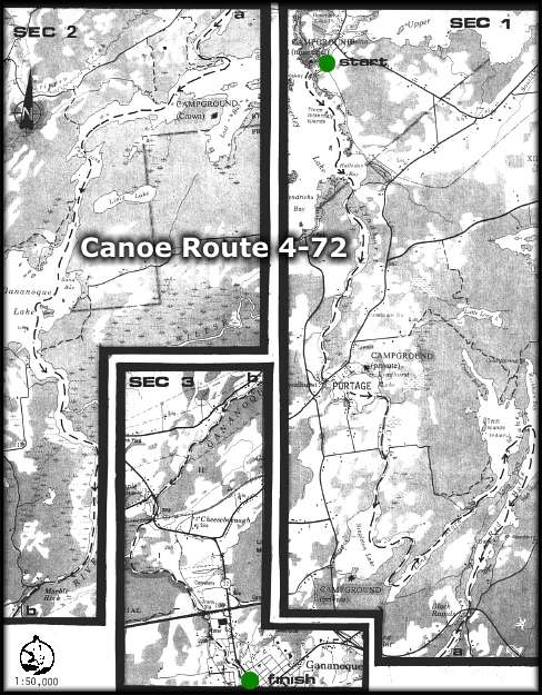
CANOE ROUTE 4-72
Route: Delta - Lower Beverly Lake - Lyndhurst Creek - Lyndhurst Lake -
Singleton Lake - Red Horse Lake - Black Rapids - Gananoque Lake -
Gananoque River - Marble Rock - Gananoque.
Distance: 96 km
Time: 2 - 3 days
Best Map: NTS 31 C-8 and NTS 31 C-9
Online: Regional Map - Canoeing Trip Planner (use BACK button to return)
- Start at the Municipal Park in the village of Delta, where parking and overnight camping is available at a nominal charge. (Telephone (613) 928-2881)
- Travel south on Lower Beverly Lake to Halladay Bay, and enter Lyndhurst Creek. Follow Lyndhurst Creek to the village, where a portage is necessary to Ford Street, on Lyndhurst Lake (about 600 metres).
- Continue around the east shore of Lyndhurst Lake and move down the creek to Singleton Lake. Keep to the east side of Singleton Lake and locate the channel leading into the Long Reach.
- Travel northeast to Red Horse Lake, round the point, then change direction south, following the channel past Black Rapids to Gananoque Lake.
- The Gananoque River exits from the Lake in the southeast corner, and can be followed to Marble Rock. A very short portage is required around the dam. Three-quarters of a kilometre downstream is Marble Rock Conservation Area. This property is owned by the Cataraqui Region Conservation Authority and is available for day use. It does not have any developed facilities at this time.
- Continue downstream to Gananoque. To reach the St. Lawrence River, you will need to portage at the dam and at the bridge.
NOTE: The more experienced canoeist may wish to extend this trip up the St. Lawrence River to Kingston, or down river to Brockville, but caution should be observed due to heavy traffic and rough water. Many campsites exist on the islands in the St. Lawrence River which comprise the St. Lawrence Islands National Park.
Cataraqui Region Conservation Authority
1641 Perth Road, Box 160
Glenburnie, Ontario K0H 1S0
Tel: 1-613-546-4228
email: crca@cataraquiregion.on.ca
The Cataraqui Region Conservation Authority would like to thank the Bayridge 'W' Scouts of Kingston for updating this route in 1996.
THE ISSUE OF THIS MAP AND DESCRIPTION DOES NOT IMPLY THAT THE USER IS GRANTED PERMISSION TO CAMP, PORTAGE OR OTHERWISE TRESPASS ON PRIVATE LANDS. THIS PERMISSION MUST BE OBTAINED FROM THE LANDOWNER. PLEASE CAMP AT THE RECOGNIZED CAMPSITES AND CARRY OUT YOUR LITTER.
For a paper copy of this route visit the Cataraqui Region Conservation Authority website: www.cataraquiregion.on.ca and download the Adobe PDF version of the route (including map) or request a paper copy from the Cataraqui Region Conservation Authority (see above).
back
webpage ©1999-2008 Ken Watson