
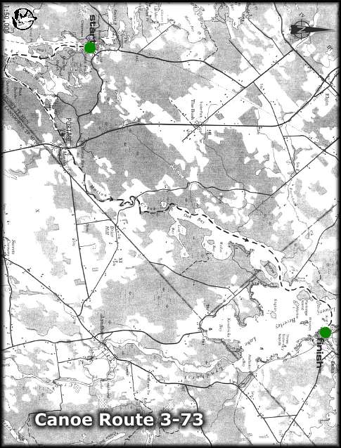
CANOE ROUTE 3-73
Route: Jones Falls - Whitefish Lake - Morton Creek - Lower Beverley Lake - Delta
Distance: 20 km
Time: 1 day
Best Map: NTS 31 C-9
Online: Regional Map - Canoeing Trip Planner (use BACK button to return)
The giant Horseshoe Dam at Jones Falls was built in the early 1800s by Colonel John By of the Royal Engineers. It was considered one of the engineering masterpieces of its day. The dam, the locks and all the massive stonework were all built by hand. The stonework, hand-cut by Scottish masons, remains in good condition.
Near the large turning basin is an historic forge, built in 1843, used to repair the hardware for the locks and dam.
- Starting at Jones Falls, travel south through the Rideau Waterway to the south end of Deans Island. To avoid the heavy traffic which may be present during mid-summer, it is recommended that canoeists follow the east shoreline in this section, staying on the east side of Goose Island and Hog Island.
- Turn northeast at the southern tip of Deans Island, into the entrance of Morton Creek. A short portage is necessary around the dam near Morton.
- Follow Morton Creek north and east to its outlet at Oak Bay. Lost Bay and Wellys Bay on the east side of Oak Bay are good areas for pike and bass fishing.
- Continue past Horse Island (watch for an Osprey nest on the northwest corner ofthe island), following the mainland past Partridge Island.
- If the weather is good, and the water is calm, travel directly across the lake (east) to the Municipal Park at Delta. Camping and day use facilities are available at the park. Call (613) 928-2881 for more information. If the water is rough, continue to travel north following the perimeter of the lake, around the top ofthe lake, then turn south to the park.
Cataraqui Region Conservation Authority
1641 Perth Road, Box 160
Glenburnie, Ontario K0H 1S0
Tel: 1-613-546-4228
email: crca@cataraquiregion.on.ca
The Cataraqui Region Conservation Authority would like to thank the Bayridge 'W' Scouts of Kingston for updating this route in 1996.
THE ISSUE OF THIS MAP AND DESCRIPTION DOES NOT IMPLY THAT THE USER IS GRANTED PERMISSION TO CAMP, PORTAGE OR OTHERWISE TRESPASS ON PRIVATE LANDS. THIS PERMISSION MUST BE OBTAINED FROM THE LANDOWNER. PLEASE CAMP AT THE RECOGNIZED CAMPSITES AND CARRY OUT YOUR LITTER.
For a paper copy of this route visit the Cataraqui Region Conservation Authority website: www.cataraquiregion.on.ca and download the Adobe PDF version of the route (including map) or request a paper copy from the Cataraqui Region Conservation Authority (see above).
back
webpage ©1999-2008 Ken Watson