
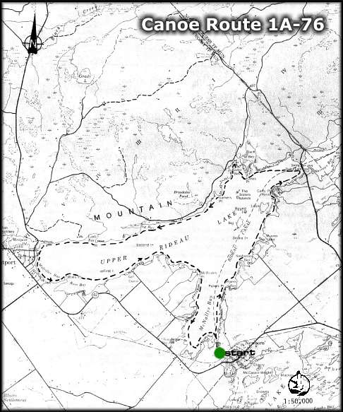
CANOE ROUTE 1A-76
Route: Newboro - McNalley's Bay - Upper Rideau Lake - Westport - Narrows
Lock - Newboro
Distance: 26 km
Time: 1 day
Best Map: Chart 1513 - Sheet 2 (Alternate Map: NTS 31 C-9)
Online: Regional Map - Canoeing Trip Planner (use BACK button to return)
- Start at the private campsite at Newboro Lock, and travel north through a short length of canal (about 0.8 km) to McNally's Bay.
Note: You are now leaving the Cataraqui Region Conservation Authority watershed and entering the Rideau Valley Conservation Authority watershed.
- The short canal which has just been travelled is one of the few stretches of actual canal which was required during construction of the Rideau Waterway.
- A private campsite exists at McBrides Point, where swimming and overnight camping is available at nominal charge.
- Continue westerly to the village of Westport, where provisions may be obtained. Docking is available under the concrete archway.
- Foley Mountain Conservation Area is located half a mile to the north, and a beautiful panoramic view of the Lake and the Village can be enjoyed from Spy Rock. Day-use facilities, including nature trails exist for the benefit of the public.
- Continue easterly, following the northern shoreline, to Narrows Lock, where one of the few remaining Blockhouses built for the defence of the Waterway has been restored.
- Upper Rideau Lake is the highest lake in the Rideau System - flowing northeast to Ottawa.
- Leaving Narrows Lock, travel south, following the shoreline back to Newboro.
Cataraqui Region Conservation Authority
1641 Perth Road, Box 160
Glenburnie, Ontario K0H 1S0
Tel: 1-613-546-4228
email: crca@cataraquiregion.on.ca
The Cataraqui Region Conservation Authority would like to thank the Bayridge 'W' Scouts of Kingston for updating this route in 1996.
THE ISSUE OF THIS MAP AND DESCRIPTION DOES NOT IMPLY THAT THE USER IS GRANTED PERMISSION TO CAMP, PORTAGE OR OTHERWISE TRESPASS ON PRIVATE LANDS. THIS PERMISSION MUST BE OBTAINED FROM THE LANDOWNER. PLEASE CAMP AT THE RECOGNIZED CAMPSITES AND CARRY OUT YOUR LITTER.
For a paper copy of this route visit the Cataraqui Region Conservation Authority website: www.cataraquiregion.on.ca and download the Adobe PDF version of the route (including map) or request a paper copy from the Cataraqui Region Conservation Authority (see above).
back
webpage ©1999-2008 Ken Watson